1980s Maps of Pine County, Minnesota
Explore 43 historic maps of Pine County from the 1980s. These maps offer a rare glimpse into what life looked like during the 1980s — showing old roads, neighborhoods, homes, and landmarks that have changed or disappeared over time.
Whether you're researching your family's past, planning a metal detecting trip, or studying how Pine County's landscape evolved across the 1980s, these high-resolution maps are a powerful tool for exploring the history of this region.
- Focus on a specific era: All maps on this page are from the 1980s, giving you a focused view of this time period.
- See what’s changed: Compare century-old streets, trails, and buildings to today's modern landscape using overlays and satellite layers.
- Research with precision: Use these maps for genealogy, historical research, land use analysis, or educational projects.
- View, download, or print: Maps are fully viewable online in high resolution, and can be downloaded or printed for your own records.
Start exploring Pine County's history through authentic maps from the 1980s. This is your window into the past.
Pine County, MN maps
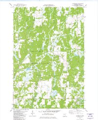
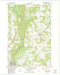
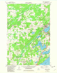
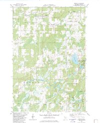
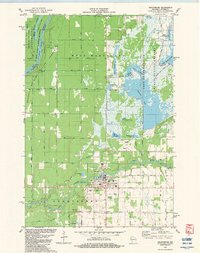
(43)- 1980 Map of Sandstone
 1980 Sandstone1980 Print · USGSPine County and the Minnesota-Wisconsin borderlands are shown here in the early eighties as a region of dense state forests and river corridors. Genealogists and historians can trace rail-town development along the Burlington Northern including Sandstone, Askov, and Hinckley.
 - 1981 Map of Cloverdale, 1982 Print
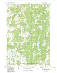
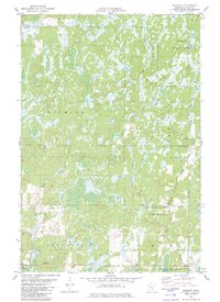
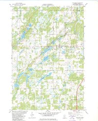
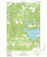
 1981 Cloverdale1982 Print · USGSPine County's conservation lands and rural townships are captured here in the early 1980s, revealing a landscape defined by state parks and game refuges. Researchers can locate the Cloverdale settlement, the Clover Cem, and early recreational features in St Croix State Park.
 - 1981 Map of Askov Lookout Tower, 1982 Print
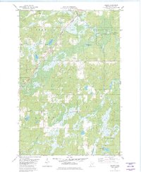
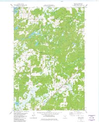
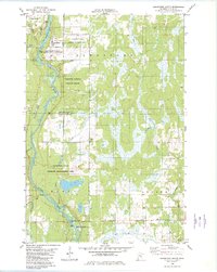
 1981 Askov Lookout Tower1982 Print · USGSPine County's northern townships are mapped here during the early 1980s, showcasing a landscape defined by timber, wetlands, and early industrial gravel works. Genealogists and local historians can locate Vilstad Ch, the Danforth Cem, and the Askov Lookout Tower.
 - 1981 Map of Kerrick, 1982 Print
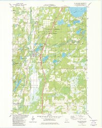
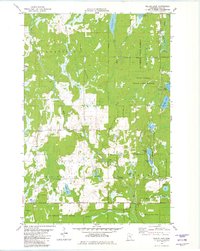
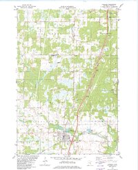
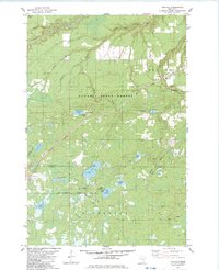
 1981 Kerrick1982 Print · USGSPine County's northern timberlands are documented in the early 1980s as the railroad still anchored local life. Researchers can trace family sites at St Michaels Cem or explore the wetlands around Kerrick and Walthausen Lake.
 - 1981 Map of Willow River, 1982 Print
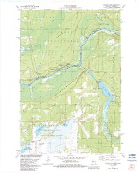
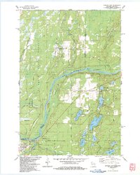
 1981 Willow River1982 Print · USGSPine County's river-and-rail corridor is captured here in the early eighties, showing the villages of Willow River and Rutledge. Local historians can trace the Military Road through the General C C Andrews State Forest and locate the Cem and Willow River Lookout Tower.
 - 1981 Map of Kettle River, 1982 Print
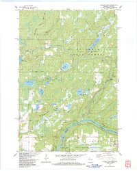
 1981 Kettle River1982 Print · USGSNear the border of Carlton and Pine counties in the early eighties, this area shows a landscape defined by its rivers and family-named roads. Genealogists can trace local heritage through landmarks like Nordland Cem, St Josephs Ch, and family routes like Greski Road.
 - 1981 Map of Hanging Horn Lake, 1982 Print
 1981 Hanging Horn Lake1982 Print · USGSBarnum and the surrounding lake country of Carlton and Pine Counties are captured here in the early 1980s. Researchers can trace local landmarks like Sunset Memorial Cem, the Drive-in Theater, and the Covered Bridge near Sturgeon Lake.
 - 1981 Map of Sandstone North, 1982 Print
 1981 Sandstone North1982 Print · USGSPine County's river-cut landscape is captured here in the early eighties as the region balanced its industrial roots with new state park conservation. Trace the path of the Burlington Northern railroad past Askov and explore the rugged geology of Hell's Gate and Wolf Creek Falls.
 - 1981 Map of Duxbury, 1982 Print
 1981 Duxbury1982 Print · USGSPine County’s wilder reaches are shown here in the early 1980s, before modern developments altered these state forest lands. Researchers can trace the rural settlement of Duxbury and find family history at Danforth Cem or the Eaglehead Lookout Tower.
 - 1981 Map of Bruno, 1982 Print
 1981 Bruno1982 Print · USGSPine County in the early eighties centers on the village of Bruno and the surrounding state forest lands and marshes. Researchers can trace the path of the Burlington Northern railroad, find local burial sites like Riverside Cem, or locate the historic Military Road through the timber.
 - 1981 Map of Nickerson, 1982 Print
 1981 Nickerson1982 Print · USGSThe border of Carlton and Pine counties is captured in the early eighties as a hub of forestry and transit. Genealogists and local historians can trace family locations near Oak Lake Ch and Oak Lake Cem or follow the Burlington Northern rail line.
 - 1981 Map of Wilbur Lake, 1982 Print
 1981 Wilbur Lake1982 Print · USGSThe Pine County backwoods come into focus in the early eighties, showing a landscape defined by state forests and conservation areas. Researchers can trace the wetlands of the Mc Gowan State Wildlife Management Area or locate family sites near Wilbur Lake and Lake Olive.
 - 1981 Map of Moose Lake, 1982 Print
 1981 Moose Lake1982 Print · USGSMoose Lake and the surrounding lake country of Carlton and Pine Counties are captured here in the early 1980s. Genealogists and local historians can locate the State Hospital, trace family roots at Finnish Cemetery, and explore the shoreline of Sturgeon Lake.
 - 1981 Map of Finlayson, 1982 Print
 1981 Finlayson1982 Print · USGSFinlayson and the surrounding Pine County wetlands are captured here in the early eighties as the region balanced its rail history with small-town growth. Genealogists and local researchers can trace the Finnish Cem, the Burlington Northern tracks, and old settlements like Groningen.
 - 1982 Map of Sandstone South
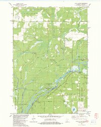
 1982 Sandstone South1982 Print · USGSThe Kettle River corridor in Pine County appears here in the early eighties, highlighting a landscape defined by extensive wildlife refuges and state park lands. Researchers can trace the boundaries of the Sandstone Federal Correctional Institution or locate local landmarks like Maple Island and the Grindstone River.
 - 1982 Map of Hinckley
 1982 Hinckley1982 Print · USGSPine County's rail and river landscape is captured here in the early eighties as the modern highway system bypasses traditional settlements. Genealogists and local historians can trace family sites at Emmanuel Ch, Evergreen Memorial Park, and the State Fish Hatchery.
 - 1982 Map of Denham
 1982 Denham1982 Print · USGSDenham and the surrounding Pine County wetlands were documented in the early eighties as the Soo Line still served the region. Genealogists and local historians can trace family locations near Denham Cemetery, the Faith Cemetery, and the Old Railroad Grade.
 - 1982 Map of Lake Clayton, 1983 Print
 1982 Lake Clayton1983 Print · USGSThe St. Croix riverfront in the early eighties shows a landscape preserved through state and national forests along the Wisconsin-Minnesota border. Researchers can trace historic river access at Nelson Landing and locate the Ekdall Ch near the marshlands.
 - 1982 Map of Yellow Lake, 1983 Print
 1982 Yellow Lake1983 Print · USGSNorthwestern Wisconsin at the start of the 1980s was a landscape defined by state forests and the winding St. Croix River. Researchers can locate remote cemeteries and camps like Bluff Lake Cem, St Johns Landing, and the Ice House Bridge.
 - 1982 Map of Monson Lake, 1983 Print
 1982 Monson Lake1983 Print · USGSUpper Wisconsin’s river borderlands are documented here in the early 1980s, showcasing the transition from state forests to vast wildlife refuges. Researchers can locate family landmarks like the Peet Cem, trace Peet Post Office Road, and find the St Johns Landing Camp along the riverbanks.
 - 1982 Map of Grantsburg, 1983 Print
 1982 Grantsburg1983 Print · USGSGrantsburg and the wetlands of Burnett County are captured here in the early eighties, where the Wood River meets a vast complex of state-managed flowages. Local historians can trace family plots at Riverside Cem or explore the outskirts of town near the County Fairground and Tobe Lake.
 - 1983 Map of Holyoke
 1983 Holyoke1983 Print · USGSThe Minnesota-Wisconsin borderlands appear here in the early eighties as a dense network of timber and wetlands within the Nemadji State Forest. You can trace the path of the Burlington Northern rail line or locate local landmarks like the Cem at Nickerson and the Old Grade.
 - 1983 Map of Danbury East
 1983 Danbury East1983 Print · USGSThe river border between Wisconsin and Minnesota comes into focus in the early 1980s, highlighting the wild corridor of the St Croix River. Genealogists and local historians can trace the tracks of the Soo Line, locate the Cem at Markville, and explore the layout of Danbury.
 - 1983 Map of Danbury West
 1983 Danbury West1983 Print · USGSThe river borderlands of Burnett County were deeply tied to conservation and tribal heritage in the early 1980s. Genealogists and historians can trace family markers at Lena Lake Cem and explore the geography of the Mille Lacs Indian Reservation.
 - 1983 Map of Black Lake
 1983 Black Lake1983 Print · USGSThe interstate borderlands of Pine and Douglas counties are shown here in the early eighties, where dense forests meet marshy lowlands. You can trace early transit routes like the Swedish Highway and locate rural communities such as Belden and Dairyland.
Showing maps 1-25 of 43
Top cities of Pine County
- Pine City historical maps
- Sandstone historical maps
- Hinckley historical maps
- Rock Creek historical maps
- Willow River historical maps
- Sturgeon Lake historical maps
See more
Frequently asked questions
- What are the different types of historical maps available for Pine County?
- What is the oldest map of Pine County?
- Where can I purchase historical maps of Pine County for my home or office?
- Where can I download high-res historical maps of Pine County?
- Are there historical topographic maps available for Pine County?
- Is there historical aerial imagery available for Pine County?
- Where are historical maps of Pine County sourced from?