1960s Maps of Red Lake County, Minnesota
Explore 5 historic maps of Red Lake County from the 1960s. These maps offer a rare glimpse into what life looked like during the 1960s — showing old roads, neighborhoods, homes, and landmarks that have changed or disappeared over time.
Whether you're researching your family's past, planning a metal detecting trip, or studying how Red Lake County's landscape evolved across the 1960s, these high-resolution maps are a powerful tool for exploring the history of this region.
- Focus on a specific era: All maps on this page are from the 1960s, giving you a focused view of this time period.
- See what’s changed: Compare century-old streets, trails, and buildings to today's modern landscape using overlays and satellite layers.
- Research with precision: Use these maps for genealogy, historical research, land use analysis, or educational projects.
- View, download, or print: Maps are fully viewable online in high resolution, and can be downloaded or printed for your own records.
Start exploring Red Lake County's history through authentic maps from the 1960s. This is your window into the past.
Red Lake County, MN maps
(5)- 1964 Map of Plummer NW, 1965 Print
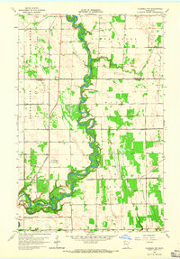 1964 Plummer NW1965 Print · USGSNorthwestern Minnesota's riverine borderlands are captured here in the mid-sixties, showing the intersection of the Red Lake and Black Rivers. Local historians can locate the St Josephs Cem, the Red Lake Falls Municipal Airport, and numerous rural Townhall sites.2 unique versions available
 - 1964 Map of Terrebonne, 1965 Print
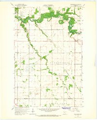 1964 Terrebonne1965 Print · USGSRed Lake County in the mid-1960s is defined by the winding Clearwater River and the rural agricultural community of Terrebonne. Researchers can trace old property boundaries via field lines or locate local landmarks like the Beau Gerlot Sch and Oak Grove Cem.
 - 1964 Map of Plummer, 1965 Print
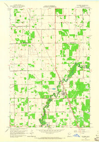 1964 Plummer1965 Print · USGSRed Lake County was a landscape of rail and river in the mid-1960s, defined by the winding Clearwater River. Genealogists and local historians can trace the foundations of Plummer and find family sites at Clara Ch Cem or St Vincent De Paul Cem.
 - 1964 Map of Brooks, 1965 Print
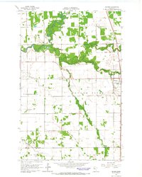 1964 Brooks1965 Print · USGSNorthern Minnesota prairie and river bottomlands are captured here in the mid-sixties, centered on the village of Brooks. Researchers can trace the SOO LINE rail corridor and locate rural landmarks like the local Cem or the winding Poplar River.
 - 1966 Map of Grand Forks
 1966 Grand Forks1966 Print · USGSThe Red River Valley in the mid-sixties shows a landscape shaped by rail-line commerce and complex water management. Genealogists and historians can trace rail-side towns like Emerado and Hunter or locate rural landmarks like the Pleasant View Church.
End of results
Showing maps 1-5 of 5
Top cities of Red Lake County
- Red Lake Falls historical maps
- Oklee historical maps
- Plummer historical maps
- Garnes historical maps
- Terrebonne historical maps
- Brooks historical maps
See more
Frequently asked questions
- What are the different types of historical maps available for Red Lake County?
- What is the oldest map of Red Lake County?
- Where can I purchase historical maps of Red Lake County for my home or office?
- Where can I download high-res historical maps of Red Lake County?
- Are there historical topographic maps available for Red Lake County?
- Is there historical aerial imagery available for Red Lake County?
- Where are historical maps of Red Lake County sourced from?