1970s Maps of Red Lake County, Minnesota
Explore 6 historic maps of Red Lake County from the 1970s. These maps offer a rare glimpse into what life looked like during the 1970s — showing old roads, neighborhoods, homes, and landmarks that have changed or disappeared over time.
Whether you're researching your family's past, planning a metal detecting trip, or studying how Red Lake County's landscape evolved across the 1970s, these high-resolution maps are a powerful tool for exploring the history of this region.
- Focus on a specific era: All maps on this page are from the 1970s, giving you a focused view of this time period.
- See what’s changed: Compare century-old streets, trails, and buildings to today's modern landscape using overlays and satellite layers.
- Research with precision: Use these maps for genealogy, historical research, land use analysis, or educational projects.
- View, download, or print: Maps are fully viewable online in high resolution, and can be downloaded or printed for your own records.
Start exploring Red Lake County's history through authentic maps from the 1970s. This is your window into the past.
Red Lake County, MN maps
(6)- 1971 Map of Oklee, 1976 Print
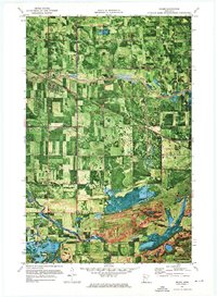 1971 Oklee1976 Print · USGSIn the early seventies, the Red Lake and Polk County borderlands were defined by the village of Oklee and its sprawling network of drainage canals. Trace the paths of the Soo Line and Hill River, and locate family sites like Zion Cem or St Francis Xavier Cem.
 - 1971 Map of Roland, 1976 Print
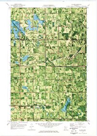 1971 Roland1976 Print · USGSRed Lake and Pennington counties are captured here in the early seventies, showing a landscape defined by the winding Clearwater River and local farmsteads. Genealogists can trace family footprints near Salem Ch, the small settlement of Roland, or the local Townhall.
 - 1971 Map of Oklee SW, 1976 Print
 1971 Oklee SW1976 Print · USGSRed Lake County enters the 1970s as a productive agricultural landscape defined by meandering riverbanks and rail-line hubs. Trace old homesteads and landmarks like the Oklee Racetrack, the Soo Line railroad, and the St Francis Xavier Cem.
 - 1972 Map of Gully NW, 1976 Print
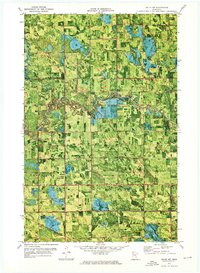
 1972 Gully NW1976 Print · USGSPennington County and its neighbors are seen here in the early 1970s, showing a landscape shaped by drainage ditches and timbered parklands. Local historians can locate the Bethany Ch, the community Townhall, and the engineered paths of Judicial Ditch No 3.
 - 1972 Map of Trail, 1976 Print
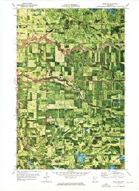
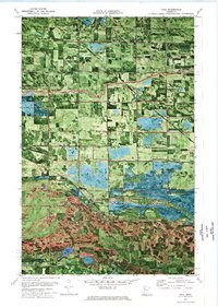 1972 Trail1976 Print · USGSThe border of Polk and Red Lake Counties comes into focus in the early 1970s, showing a landscape of drainage ditches and conservation areas. Researchers can locate St Charles Ch, the Mt Olive Cem, and traces of the Indian Reservation Line near the village of Trail.
 - 1972 Map of Oklee NW, 1976 Print
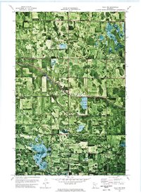
 1972 Oklee NW1976 Print · USGSRed Lake and Pennington counties are shown in the early 1970s as agricultural drainage projects and the Soo Line railroad defined the rural landscape. Local historians can trace the Indian Reservation Boundary and locate landmarks like the Finnish Cem and Ebenezer Ch.
End of results
Showing maps 1-6 of 6
Top cities of Red Lake County
- Red Lake Falls historical maps
- Oklee historical maps
- Plummer historical maps
- Garnes historical maps
- Terrebonne historical maps
- Brooks historical maps
See more
Frequently asked questions
- What are the different types of historical maps available for Red Lake County?
- What is the oldest map of Red Lake County?
- Where can I purchase historical maps of Red Lake County for my home or office?
- Where can I download high-res historical maps of Red Lake County?
- Are there historical topographic maps available for Red Lake County?
- Is there historical aerial imagery available for Red Lake County?
- Where are historical maps of Red Lake County sourced from?