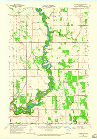
1964 Map of Plummer NW
USGS Topo · Published 1965About this map
The Red Lake River carves a deeply sinuous path through this mid-1960s landscape, marking the boundary where the agricultural plains are etched by an extensive network of drainage projects. This intricate system includes County Ditch No 76, Judicial Ditch No 15, and County Ditch No 12, which serve to manage the water levels of the low-lying prairie land. The confluence of the Black River and the main channel occurs amidst a terrain scattered with local infrastructure, from the rural Townhall locations to the Red Lake Falls Municipal Airport. For those tracing local heritage, the map identifies significant sites such as St Josephs Cem and Oak Grove Cem in the southern reaches, alongside the isolated Gervais Lake. The landscape reflects a mix of natural riparian curves and the rigid geometry of man-made waterways and Gravel Pits.
Find a feature on this map
20 named features on this map. Tap any name to fly to it.
Don’t see what you’re looking for? This feature index may not catch every label — zoom into the map to look around manually.
Map Details
Editions of this 1964 Plummer NW Map
2 editions found
Other maps of this area

1918 · Terrebonne
USGS Topo · 1:62,500

1918 · Red Lake Falls
USGS Topo · 1:62,500

1918 · Viking
USGS Topo · 1:62,500

1943 · Thief River Falls
USGS Topo · 1:62,500

1952 · Red Lake Falls
USGS Topo · 1:62,500

1952 · Grand Forks
USGS Topo · 1:250,000

1952 · Thief River Falls
USGS Topo · 1:250,000

1956 · Thief River Falls
USGS Topo · 1:250,000

1956 · Grand Forks
USGS Topo · 1:250,000

1957 · Thief River Falls
USGS Topo · 1:250,000