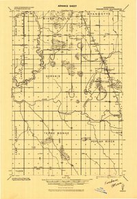
1918 Map of Terrebonne
USGS Topo · Published 1943About this map
Red Lake River and the Clearwater River dominate this 1918 landscape in Northern Minnesota, carving intricate meanders across the townships of Gervais, Emardville, and Terre Bonne. The railroad network is a primary focus, featuring the junction of the Minneapolis St. Paul and Sault Ste. Marie and the Great Northern near the settlement of Plummer.
Find a feature on this map
29 named features on this map. Tap any name to fly to it.
Don’t see what you’re looking for? This feature index may not catch every label — zoom into the map to look around manually.
Map Details
Editions of this 1918 Terrebonne Map
2 editions found
Other maps of this area

1918 · Terrebonne
USGS Topo · 1:62,500

1918 · Red Lake Falls
USGS Topo · 1:62,500

1918 · Viking
USGS Topo · 1:62,500

1919 · Grit
USGS Topo · 1:62,500

1919 · Valley
USGS Topo · 1:62,500

1943 · Thief River Falls
USGS Topo · 1:62,500

1952 · Red Lake Falls
USGS Topo · 1:62,500

1952 · Grand Forks
USGS Topo · 1:250,000

1952 · Thief River Falls
USGS Topo · 1:250,000

1954 · Bemidji
USGS Topo · 1:250,000