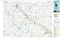
1980s Maps of Renville County, Minnesota
Explore 19 historic maps of Renville County from the 1980s. These maps offer a rare glimpse into what life looked like during the 1980s — showing old roads, neighborhoods, homes, and landmarks that have changed or disappeared over time.
Whether you're researching your family's past, planning a metal detecting trip, or studying how Renville County's landscape evolved across the 1980s, these high-resolution maps are a powerful tool for exploring the history of this region.
- Focus on a specific era: All maps on this page are from the 1980s, giving you a focused view of this time period.
- See what’s changed: Compare century-old streets, trails, and buildings to today's modern landscape using overlays and satellite layers.
- Research with precision: Use these maps for genealogy, historical research, land use analysis, or educational projects.
- View, download, or print: Maps are fully viewable online in high resolution, and can be downloaded or printed for your own records.
Start exploring Renville County's history through authentic maps from the 1980s. This is your window into the past.
Renville County, MN maps
(19)- 1982 Map of Heatwole
 1982 Heatwole1982 Print · USGSMcLeod County’s lake country is captured in the early eighties, showing a landscape defined by conservation and rural family life. Researchers can trace the grounds of Trinity Cem, the small settlement of Heatwole, and the shores of Lake Marion.
 - 1982 Map of Hutchinson West
 1982 Hutchinson West1982 Print · USGSHutchinson and the surrounding Acoma Township are captured in the early eighties as the town expanded toward the Crow River. Genealogists and local researchers can locate the Acoma Cem, Immanuel Sch, and numerous family landmarks near Cedar Lake.2 unique versions available
 - 1982 Map of Morgan NE, 1983 Print
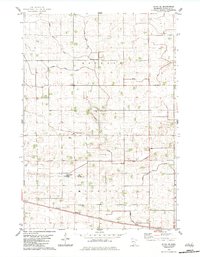
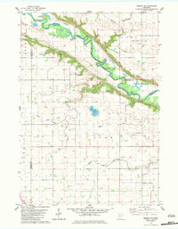 1982 Morgan NE1983 Print · USGSThe Minnesota River valley and its rural townships are captured here in the early 1980s as the agricultural landscape matured. Researchers can locate numerous local landmarks including Mt Hope Cem, Kettners Landing, and the Old Indian Treaty Boundary.
 - 1982 Map of Vicksburg, 1983 Print
 1982 Vicksburg1983 Print · USGSThe Minnesota River valley meets the agricultural heartland of Renville County in the early eighties. Genealogists and local historians can trace rural roots at St Matthew Ch, Zion Cem, and the Old Indian Treaty Boundary.
 - 1982 Map of Olivia SE, 1983 Print
 1982 Olivia SE1983 Print · USGSRenville County in the early eighties is a landscape of productive prairie and sophisticated water engineering. Genealogists and local historians can trace the Chicago Milwaukee St Paul and Pacific rail line, St Johns Ch, and the Elim Moravian Cem.
 - 1982 Map of Lake Lillian, 1983 Print
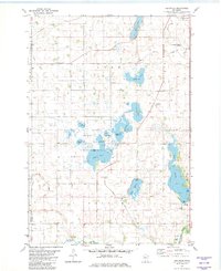
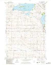 1982 Lake Lillian1983 Print · USGSKandiyohi County in the early eighties exhibits a landscape defined by glacial lakes and a deep agricultural heritage. Genealogists can locate several family-linked burial sites including Tromso Cem and Evergreen Cem near the village of Lake Lillian.
 - 1982 Map of Redwood Falls, 1983 Print
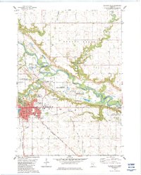 1982 Redwood Falls1983 Print · USGSRedwood Falls and the Minnesota River valley appear here in the early eighties as a hub of rail transit and riverfront industry. Local historians can trace the Old Indian Treaty Boundary and locate family plots at Beaver Falls Cem or St Catherine Cem Redwood Falls Cem.2 unique versions available
 - 1982 Map of Thorpe, 1983 Print
 1982 Thorpe1983 Print · USGSSouthern Kandiyohi County was a patchwork of wetlands and managed farmland in the early 1980s. Genealogists and historians can trace family locations near Wagemaker and Swenson, or locate landmarks like the Lake Lillian Ch and the Luce Line State Trail.
 - 1982 Map of Stewart, 1983 Print
 1982 Stewart1983 Print · USGSStewart and the surrounding McLeod County prairie are shown here in the early eighties as the agricultural landscape matured. Genealogists can trace family footprints near Fernando, St Boniface Cem, and the St Pauls Ch parish.
 - 1982 Map of Olivia, 1983 Print
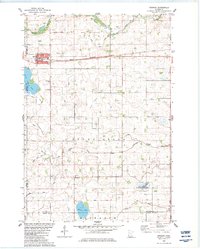
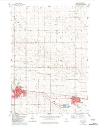 1982 Olivia1983 Print · USGSRenville County farmland was well-established by the early eighties, centered on the corridor between Olivia and Bird Island. You can trace family history through sites like Bird Island Cem, St Aloysius Sch, and the local Courthouse.
 - 1983 Map of Morton NE
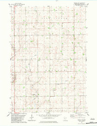
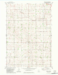 1983 Morton NE1983 Print · USGSRenville County farmland was meticulously managed by the early eighties, characterized by a complex grid of drainage and township lines. Researchers can locate local landmarks like Palmyra American Townhall Ch and the St Paul Cem.
 - 1983 Map of Bechyn
 1983 Bechyn1983 Print · USGSRenville County farmland and prairie drainage are frozen in time during the early eighties, centered on the small settlement of Bechyn. Genealogists and researchers can trace township lines through Henryville and Flora or follow the paths of Beaver Creek and West Fork.
 - 1983 Map of Morton NW
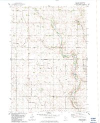
 1983 Morton NW1983 Print · USGSRenville County prairie lands and townships are mapped here in the early eighties as agriculture and drainage systems reshaped the terrain. Trace rural landmarks like the Townhall in Norfolk and the Lotherts Landing Strip near Birch Cooley.
 - 1983 Map of Morton
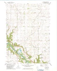
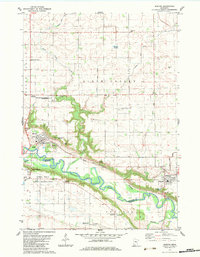 1983 Morton1983 Print · USGSRenville and Redwood counties meet along the river valley in the early 1980s, where agriculture and history intersect. Genealogists and historians can locate several family burial grounds like St Patrick Cem and trace landmarks such as the Birch Coulee Battlefield Historic Site.
 - 1983 Map of Delhi
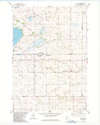
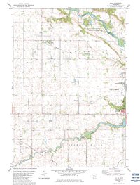 1983 Delhi1983 Print · USGSRedwood and Renville Counties are captured in the early eighties as the agricultural landscape surrounds the growing town of Redwood Falls. Genealogists and researchers can trace the Old Indian Treaty Boundary and locate early sites like Delhi and Ramsey Falls.
 - 1983 Map of Morton SE
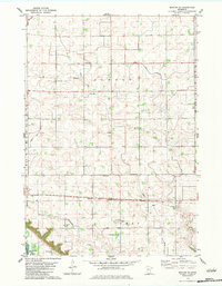 1983 Morton SE1983 Print · USGSRenville County farmland and the Minnesota River valley are captured here in the early eighties, showing a landscape shaped by drainage and rail. Researchers can trace local heritage through numerous burial sites like Finnish Cem and the Chicago and North Western line.
 - 1986 Map of Montevideo
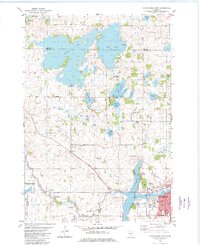
 1986 Montevideo1986 Print · USGSWestern Minnesota’s river valleys and prairie townships are captured here in the mid-eighties, showing the region's agricultural and rail network. Trace family roots and local history through Montevideo, Granite Falls, and the Upper Sioux Agency State Park.2 unique versions available
 - 1986 Map of New Ulm
 1986 New Ulm1986 Print · USGSSouthern Minnesota's river valleys and prairie townships are captured here in the mid-1980s, showcasing a landscape defined by agriculture and transit. Researchers can trace the Chicago and North Western rail lines through historic grain-stop towns like Sleepy Eye, Hanska, and Good Thunder.
 - 1986 Map of Glencoe
 1986 Glencoe1986 Print · USGSThe south-central Minnesota prairie and its glacial lake basins are captured here in the mid-1980s, showcasing a landscape of intensive farming and conservation. Genealogists can locate family-named landmarks and trace the rail lines of the Soo Line and Chicago and North Western through towns like Gaylord, Olivia, and Hutchinson.2 unique versions available
End of results
Showing maps 1-19 of 19
Top cities of Renville County
- Olivia historical maps
- Fairfax historical maps
- Bird Island historical maps
- Hector historical maps
- Buffalo Lake historical maps
- Sacred Heart historical maps
See more
Frequently asked questions
- What are the different types of historical maps available for Renville County?
- What is the oldest map of Renville County?
- Where can I purchase historical maps of Renville County for my home or office?
- Where can I download high-res historical maps of Renville County?
- Are there historical topographic maps available for Renville County?
- Is there historical aerial imagery available for Renville County?
- Where are historical maps of Renville County sourced from?