1950s Maps of Renville County, Minnesota
Explore 9 historic maps of Renville County from the 1950s. These maps offer a rare glimpse into what life looked like during the 1950s — showing old roads, neighborhoods, homes, and landmarks that have changed or disappeared over time.
Whether you're researching your family's past, planning a metal detecting trip, or studying how Renville County's landscape evolved across the 1950s, these high-resolution maps are a powerful tool for exploring the history of this region.
- Focus on a specific era: All maps on this page are from the 1950s, giving you a focused view of this time period.
- See what’s changed: Compare century-old streets, trails, and buildings to today's modern landscape using overlays and satellite layers.
- Research with precision: Use these maps for genealogy, historical research, land use analysis, or educational projects.
- View, download, or print: Maps are fully viewable online in high resolution, and can be downloaded or printed for your own records.
Start exploring Renville County's history through authentic maps from the 1950s. This is your window into the past.
Renville County, MN maps
(9)- 1952 Map of Morton, 1954 Print
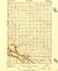 1952 Morton1954 Print · USGSRenville County farmland meets the deep Minnesota River valley in the early fifties, showing a landscape shaped by granite quarrying and river transport. Researchers can locate numerous country schools and churches like Swedlanda Ch, the Lower Sioux Indian Community, and the grounds of Fort Ridgely.2 unique versions available
 - 1952 Map of Redwood Falls, 1954 Print
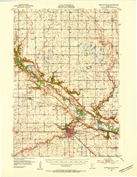 1952 Redwood Falls1954 Print · USGSRedwood Falls and the Minnesota River valley are captured in detail during the early fifties, showing the area's deep agricultural and river-town roots. Researchers can trace rural school districts, the Chicago and North Western rail line, and the Lower Sioux Indian Community.2 unique versions available
 - 1953 Map of Morgan, 1955 Print
 1953 Morgan1955 Print · USGSRedwood and Brown Counties are shown at their agricultural peak in the early fifties, anchored by the rail hub at Morgan. Genealogists and historians can trace dozens of rural schoolhouses and country churches like Brookville Church or Immanuel Church.
 - 1953 Map of New Ulm, 1968 Print
 1953 New Ulm1968 Print · USGSSouthern Minnesota in the mid-1950s is defined by its deep river valleys and the expanding reach of the Great Northern and Chicago and North Western railroads. Researchers can trace rural lineages through landmarks like the Milford State Monument, St. John's Ch, and the Upper Sioux Indian Res.3 unique versions available
 - 1957 Map of New Ulm
 1957 New Ulm1957 Print · USGSCentral Minnesota in the mid-fifties remains a landscape of river-valley commerce and prairie agriculture defined by its historic mission sites and rail towns. Genealogists and local historians can trace the development of New Ulm and Montevideo, or locate specific landmarks like the Milford State Monument and Minnesota Falls.
 - 1957 Map of Olivia, 1959 Print
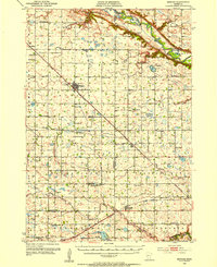
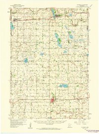
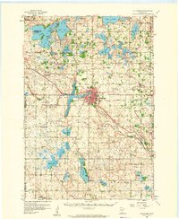
 1957 Olivia1959 Print · USGSRenville and Kandiyohi Counties are shown during the late fifties, defined by a dense grid of farm roads and competing rail lines. Genealogists can locate family landmarks like Christina Cem, St Johns Ch, and the village of Olivia.
 - 1958 Map of New Ulm
 1958 New Ulm1958 Print · USGSSouth-central Minnesota’s river valleys and prairie towns are captured here in the mid-fifties, during the height of the region's rail-and-river economy. Genealogists and historians can trace the legacy of the Upper Sioux Indian Mission or locate early rail stops along the Chicago and North Western Ry in towns like Redwood Falls and Glencoe.
 - 1958 Map of Winthrop, 1959 Print
 1958 Winthrop1959 Print · USGSMid-century Sibley and McLeod counties are captured here as the rail-centered agricultural landscape reached its peak. Genealogists can trace family roots through several rural landmarks like St Boniface Cem, St John Sch, and the town of Winthrop.
 - 1958 Map of Hutchinson, 1959 Print
 1958 Hutchinson1959 Print · USGSHutchinson and the surrounding McLeod County townships are captured here in the late fifties at a height of rail-driven agricultural activity. Genealogists can trace family footprints through numerous rural landmarks like Zion Ch, Stahl Lake Sch, and the Immanuel Sch Cem.
End of results
Showing maps 1-9 of 9
Top cities of Renville County
- Olivia historical maps
- Fairfax historical maps
- Bird Island historical maps
- Hector historical maps
- Buffalo Lake historical maps
- Sacred Heart historical maps
See more
Frequently asked questions
- What are the different types of historical maps available for Renville County?
- What is the oldest map of Renville County?
- Where can I purchase historical maps of Renville County for my home or office?
- Where can I download high-res historical maps of Renville County?
- Are there historical topographic maps available for Renville County?
- Is there historical aerial imagery available for Renville County?
- Where are historical maps of Renville County sourced from?