1960s Maps of Morse Township, Minnesota
Explore 6 historic maps of Morse Township from the 1960s. These maps offer a rare glimpse into what life looked like during the 1960s — showing old roads, neighborhoods, homes, and landmarks that have changed or disappeared over time.
Whether you're researching your family's past, planning a metal detecting trip, or studying how Morse Township's landscape evolved across the 1960s, these high-resolution maps are a powerful tool for exploring the history of this region.
- Focus on a specific era: All maps on this page are from the 1960s, giving you a focused view of this time period.
- See what’s changed: Compare century-old streets, trails, and buildings to today's modern landscape using overlays and satellite layers.
- Research with precision: Use these maps for genealogy, historical research, land use analysis, or educational projects.
- View, download, or print: Maps are fully viewable online in high resolution, and can be downloaded or printed for your own records.
Start exploring Morse Township's history through authentic maps from the 1960s. This is your window into the past.
Morse Township, MN maps
(6)- 1964 Map of Hibbing
 1964 Hibbing1964 Print · USGSNorthern Minnesota’s iron-rich corridor is captured here during a peak era of mid-century industrial activity. Researchers can trace the rail-to-mine connections through Mesabi Range towns like Hibbing and Virginia or locate lakefront settlements near Pokegama Lake.
 - 1964 Map of Two Harbors
 1964 Two Harbors1964 Print · USGSThe North Shore of Lake Superior is captured here during the mid-1950s, a time of significant industrial mining growth and emerging tourism. Genealogists and historians can trace the rail lines of the Duluth Missabe and Iron Range and locate landmarks like Split Rock Light and the U S Air Force Radar Station.
 - 1965 Map of Shagawa Lake, 1967 Print
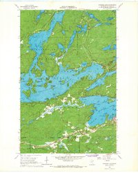 1965 Shagawa Lake1967 Print · USGSThe Iron Range meets the Boundary Waters in the 1960s, showing the town of Ely surrounded by a labyrinth of islands and forests. You can trace the Duluth Missabe and Iron Range rail line past local sites like Semer Park and Longstorff Bay.3 unique versions available
 - 1965 Map of Bear Island, 1967 Print
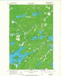 1965 Bear Island1967 Print · USGSSt. Louis County was a land of intricate waterways and deep timber in the mid-1960s. Researchers can trace depth soundings and shorelines around Bear Island Lake, locate the settlement of Rothman, and find old Sandpits and public Boat Ramps.3 unique versions available
 - 1965 Map of Ely, 1967 Print
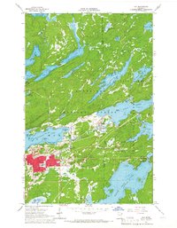 1965 Ely1967 Print · USGSEly and Winton are captured in the mid-sixties as they balanced a legacy of iron mining with their growing status as wilderness gateways. Researchers can trace the Duluth Missabe and Iron Range rail line, locate the Pioneer Mine, or find local landmarks like the Lincoln Sch and Ely Cem.3 unique versions available
 - 1965 Map of Kangas Bay, 1967 Print
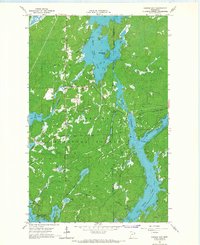 1965 Kangas Bay1967 Print · USGSThe North Woods during the mid-sixties are defined by the expansive waters of the Superior National Forest and the engineered Birch Lake Dam. Researchers can trace the reservoir shoreline and locate local landmarks like the Birch Lake Cem and Beargrease Island.3 unique versions available
End of results
Showing maps 1-6 of 6
Top cities near Morse Township
Top neighborhoods of Morse Township
- Robinson historical maps
- Burntside historical maps
- Burntside Lake historical maps
- Winton historical maps
Frequently asked questions
- What are the different types of historical maps available for Morse Township?
- What is the oldest map of Morse Township?
- Where can I purchase historical maps of Morse Township for my home or office?
- Where can I download high-res historical maps of Morse Township?
- Are there historical topographic maps available for Morse Township?
- Is there historical aerial imagery available for Morse Township?
- Where are historical maps of Morse Township sourced from?