1970s Maps of Wabasha County, Minnesota
Explore 18 historic maps of Wabasha County from the 1970s. These maps offer a rare glimpse into what life looked like during the 1970s — showing old roads, neighborhoods, homes, and landmarks that have changed or disappeared over time.
Whether you're researching your family's past, planning a metal detecting trip, or studying how Wabasha County's landscape evolved across the 1970s, these high-resolution maps are a powerful tool for exploring the history of this region.
- Focus on a specific era: All maps on this page are from the 1970s, giving you a focused view of this time period.
- See what’s changed: Compare century-old streets, trails, and buildings to today's modern landscape using overlays and satellite layers.
- Research with precision: Use these maps for genealogy, historical research, land use analysis, or educational projects.
- View, download, or print: Maps are fully viewable online in high resolution, and can be downloaded or printed for your own records.
Start exploring Wabasha County's history through authentic maps from the 1970s. This is your window into the past.
Wabasha County, MN maps
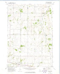
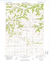
(18)- 1972 Map of Plainview, 1975 Print
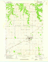 1972 Plainview1975 Print · USGSWabasha County agricultural and forest lands are documented here in the early 1970s, showcasing the region's rail and river connections. Researchers can trace local heritage through sites like St Joachim Cem and the Chicago and North Western rail line.
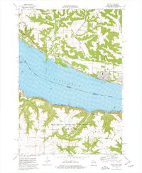
 - 1972 Map of Zumbro Lake, 1975 Print
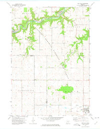
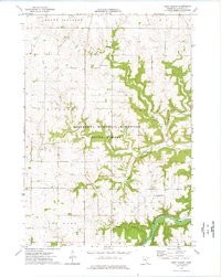
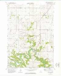
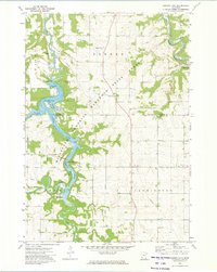 1972 Zumbro Lake1975 Print · USGSThe Zumbro River valley in the early seventies shows a transition between wooded state forest land and the steady agricultural grids of Olmsted County. Researchers can trace riverside developments at Cedar Beach, find the Woodville Chapel, or locate rural burials at Farm Hill Cem.2 unique versions available
 - 1972 Map of Plainview SW, 1975 Print
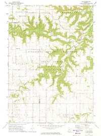
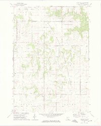 1972 Plainview SW1975 Print · USGSSoutheast Minnesota in the early seventies reveals a landscape of deep river valleys and high agricultural plateaus. Researchers can trace rural life through sites like St Pauls Ch, Little Valley Cem, and the wooded stretches of Carley State Park.2 unique versions available
 - 1972 Map of Beaver, 1975 Print
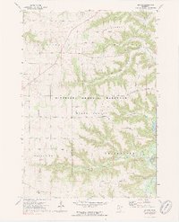 1972 Beaver1975 Print · USGSSoutheast Minnesota's bluff country is captured here in the early seventies, showing the junction of the Whitewater River and Beaver Creek. Genealogists can locate several rural burial sites, including Beaver Cem and Hoosier Ridge Cem, along with the Hoosier Ridge Ch.2 unique versions available
 - 1972 Map of Chester, 1975 Print
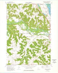
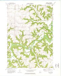
 1972 Chester1975 Print · USGSOlmsted County’s rural townships are captured here in the early seventies, showing a landscape defined by small rail stops and upland forests. Researchers can locate the Haverhill Sch, trace the Chicago and North Western rail line, or find family plots at Haverhill Cem and Oak Hill Cem.
 - 1972 Map of Millville, 1975 Print
 1972 Millville1975 Print · USGSThe Zumbro River valley and its surrounding plateaus appear here in the early 1970s, showing a landscape of river towns and high-ground farming. Genealogists and local historians can trace small communities like Millville and Bremen, or locate rural landmarks such as Oakwood Ch and Pleasant Prairie Cem.
 - 1972 Map of Elba, 1975 Print
 1972 Elba1975 Print · USGSSoutheast Minnesota's bluff country is captured here in the 1970s, where the Whitewater River forks converge near the town of Elba. Researchers can locate rural landmarks such as St Aloysius Cem, the Lookout Tower, and the remote crossroads of Kingsley Corner.2 unique versions available
 - 1972 Map of Cochrane, 1976 Print
 1972 Cochrane1976 Print · USGSThe upper Mississippi riverfront and its surrounding bluffs are captured here in the early seventies, showing a landscape defined by navigation and nature. Genealogists and historians can trace the streets of Cochrane, locate the Mount Vernon Cem, and see the rail lines of the Burlington Northern.2 unique versions available
 - 1972 Map of Weaver, 1976 Print
 1972 Weaver1976 Print · USGSThe river bluffs and backwaters of Winona County are captured in the early seventies, showing a landscape shaped by timber and the Mississippi. Researchers can trace the tracks of the Chicago Milwaukee St Paul and Pacific and locate local landmarks like St Marys Cem Evergreen Sem or Mount Vernon.2 unique versions available
 - 1974 Map of West Albany, 1976 Print
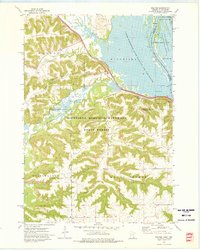
 1974 West Albany1976 Print · USGSWabasha County in the mid-1970s is shown here as a landscape of deep ravines and plateau farms within the Minnesota Memorial Hardwood State Forest. Researchers can locate West Albany, trace the Zumbro River, and find family sites at Jacksonville Cem.
 - 1974 Map of Wabasha South, 1976 Print
 1974 Wabasha South1976 Print · USGSThe river bluffs and bottomlands of Wabasha County are captured here in the mid-seventies as the rail-and-river economy persists. Genealogy and local history enthusiasts can trace the Chicago Milwaukee St Paul and Pacific line through Wabasha, Midland Junction, and the St Agnes Cem near Kellogg.
 - 1974 Map of Wabasha North, 1976 Print
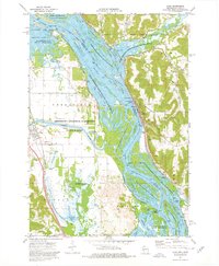
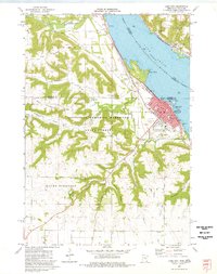
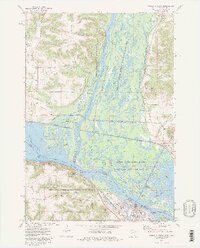 1974 Wabasha North1976 Print · USGSThe confluence of the Mississippi and Chippewa Rivers comes alive in the mid-seventies, showing the riverfront towns of Wabasha and Reads Landing. Genealogists can locate family landmarks like St Felix Cem and Riverview Cem alongside the heavy rail corridors of the Burlington Northern.2 unique versions available
 - 1974 Map of Lake City NW, 1976 Print
 1974 Lake City NW1976 Print · USGSGoodhue and Wabasha counties appear in the mid-1970s as a landscape of wooded ridges and well-defined farmsteads. Researchers can locate rural community markers like Stameier, St Peters Ch, and the landmark Sugarloaf peak overlooking the creek valleys.
 - 1974 Map of Pepin, 1976 Print
 1974 Pepin1976 Print · USGSThe Mississippi River valley at Lake Pepin comes to life in the mid-1970s, showcasing the river-and-rail corridor connecting Wisconsin and Minnesota. Genealogists and historians can trace riverside settlements like Stockholm and Pepin, and locate rural landmarks such as Oakwood Cem and Bogus Bluff.
 - 1974 Map of Alma, 1976 Print
 1974 Alma1976 Print · USGSThe Upper Mississippi River corridor is captured here in the mid-1970s, showing the intricate wetlands and industrial river crossings of the border region. You can trace the rail lines of the Burlington Northern and locate sites like Lock and Dam No 4 or the Mill Creek Cem.2 unique versions available
 - 1974 Map of Theilman, 1976 Print
 1974 Theilman1976 Print · USGSTheilman and the Zumbro River valley are captured in the mid-1970s, showcasing a landscape of deep coulees and conservation lands. Genealogists and local historians can locate the Scott Settlement Cem, the river crossing at Funk Ford, and family-named landmarks like Bade Coulee.
 - 1974 Map of Zumbro Falls, 1976 Print
 1974 Zumbro Falls1976 Print · USGSWabasha County's bluff country is captured in the mid-seventies, showing the winding river valley and rural highlands as they appeared before modern expansion. Genealogists can locate several remote burial sites, including Black Cem and Chester Cem, or trace the path of the Old Railroad Grade.
 - 1974 Map of Lake City, 1977 Print
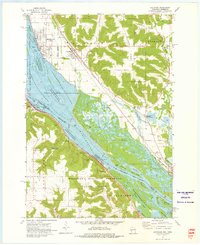
 1974 Lake City1977 Print · USGSThe wide waters of the Mississippi River and the steep bluffs of the hardwood forest defined life along the river valley in the mid-seventies. Genealogists and local historians can trace the foundations of Lake City, locate the Lincoln Sch, and find family names at Lakewood Cem or Vining Cem.
End of results
Showing maps 1-18 of 18
Top cities of Wabasha County
- Lake City historical maps
- Plainview historical maps
- Wabasha historical maps
- Elgin historical maps
- Mazeppa historical maps
- Kellogg historical maps
See more
Frequently asked questions
- What are the different types of historical maps available for Wabasha County?
- What is the oldest map of Wabasha County?
- Where can I purchase historical maps of Wabasha County for my home or office?
- Where can I download high-res historical maps of Wabasha County?
- Are there historical topographic maps available for Wabasha County?
- Is there historical aerial imagery available for Wabasha County?
- Where are historical maps of Wabasha County sourced from?