Old Maps of Wabasha County, Minnesota for Academic Research
Study the evolution of Wabasha County with 128 high-resolution historic maps. Whether you're teaching, researching, or modeling changes in land use, these maps provide essential visual documentation of urban, environmental, and geographic change.
- Analyze long-term change: Track patterns in development, transportation, and natural features.
- Ideal for environmental or urban studies: Support academic projects with primary historical map data.
- Use in the classroom or lab: Educators and researchers rely on these maps to bring historical context to life.
These maps are a powerful tool for teaching, research, and visualizing how Wabasha County has changed over the decades.
Wabasha County, MN maps
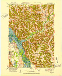
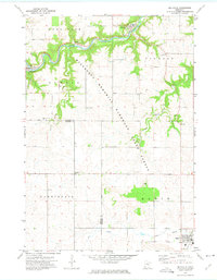
(128)- 1932 Map of Cochrane
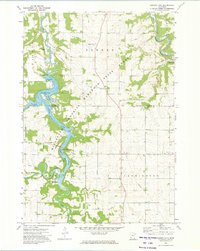
 1932 Cochrane1932 Print · USGSThe Mississippi River valley in the early thirties shows a intricate network of islands and sloughs tucked beneath high bluffs. Trace the historical footprints of Buffalo City, locate rural schoolhouses like Oak Valley Sch, and follow the Chicago Burlington and Quincy rail line.
 - 1932 Map of Wabasha
 1932 Wabasha1932 Print · USGSThe Mississippi River valley near the Chippewa delta was a thriving hub of rail and river commerce in the early thirties. Genealogists can trace early homesteads and community hubs through landmarks like Hicks Valley Sch, Stockholm, and the river crossing at Nelson.2 unique versions available
 - 1932 Map of Alma
 1932 Alma1932 Print · USGSThe river valleys and high ridges of Buffalo County are captured here in the early 1930s, showing a landscape of small farms and rural schoolhouses. Genealogists and local historians can trace the foundations of this community through dozen of school sites like Mill Creek Sch and Cascade Sch, alongside the U S Game Refuge and the rail lines through Alma.2 unique versions available
 - 1934 Map of Plainview, 1960 Print
 1934 Plainview1960 Print · USGSWabasha and Winona Counties are shown in the mid-1930s as the railroad era connects prairie towns to the dramatic river bluffs. Genealogists can trace rural homesteads through a dense network of district schools like Fisher Hill Sch and historic grounds such as the Wabasha County Fair Grounds.
 - 1934 Map of Cochrane, 1968 Print
 1934 Cochrane1968 Print · USGSThe Mississippi River corridor and surrounding bluffs are captured here in the mid-1930s, documenting the riverside rail lines and upland farm communities. Genealogists can trace family landmarks like Young Cem, Mount Vernon Sch, and the Transient Relief Camp.
 - 1935 Map of Rochester
 1935 Rochester1935 Print · USGSSoutheastern Minnesota during the mid-thirties reveals a landscape of thriving river towns and dense rural school districts. Genealogists and historians can trace family roots through numerous country schools like Sch No 106 and cemeteries such as Pleasant Prairie Cem.
 - 1937 Map of Cochrane
 1937 Cochrane1937 Print · USGSThe Mississippi River bluffs during the late thirties show a region defined by river navigation and rural township life. Genealogists can trace family roots through numerous local landmarks like Hebron Ch, Mount Vernon Cem, and schools from Buffalo to Rollingstone.2 unique versions available
 - 1938 Map of Plainview
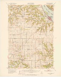
 1938 Plainview1938 Print · USGSSoutheastern Minnesota's driftless landscape was a patchwork of family farms and rural school districts in the late thirties. Genealogists and historians can trace the foundations of Plainview and Elba, and locate several burial grounds like Greenwood Cem and Fairwater Cem.2 unique versions available
 - 1939 Map of Rochester
 1939 Rochester1939 Print · USGSRochester and the Zumbro River valley are captured here in the mid-thirties, showcasing the city's early layout and the surrounding agrarian townships. Genealogists can trace family roots through dozens of named country schools and churches like South Troy Ch and Webster Sch.4 unique versions available
 - 1950 Map of Alma, 1952 Print
 1950 Alma1952 Print · USGSThe Mississippi River valley serves as a bustling corridor for rail and river traffic at mid-century. Genealogists can trace family roots through numerous rural landmarks like St Paul Ch, Church Valley Cem, and the riverfront town of Alma.8 unique versions available
 - 1951 Map of Wabasha
 1951 Wabasha1951 Print · USGSThe Mississippi River valley and Lake Pepin define this mid-century landscape at the border of Minnesota and Wisconsin. Researchers can trace rural school districts like Scott Settlement Sch and old river settlements from Stockholm to Wabasha.3 unique versions available
 - 1951 Map of Lake City, 1953 Print
 1951 Lake City1953 Print · USGSLake City and the high bluffs overlooking the Mississippi River appear here at mid-century, documenting a landscape shaped by the rail lines and river valleys of the Upper Midwest. Researchers can locate numerous country landmarks like Sugarloaf Valley Sch, Florence Stn, and the historic Zumbro Falls.3 unique versions available
 - 1953 Map of Saint Paul, 1964 Print
 1953 Saint Paul1964 Print · USGSThe Twin Cities and the Mississippi River valley are captured here at a mid-century turning point. Trace the early growth of Minneapolis and Saint Paul alongside landmarks like Lake Minnetonka and the St Croix River.4 unique versions available
 - 1953 Map of Eau Claire, 1965 Print
 1953 Eau Claire1965 Print · USGSWest-central Wisconsin in the mid-fifties shows a landscape of river-valley industry and vast wildlife refuges during the transition from rails to modern highways. Genealogists and historians can trace the rail corridors of the Chicago and North Western or locate family-named landmarks like Decorah Mound and Chippewa Island.4 unique versions available
 - 1958 Map of Eau Claire
 1958 Eau Claire1958 Print · USGSWestern Wisconsin in the late fifties shows a landscape of growing regional hubs and massive wildlife refuges. Trace the rail lines of the Chicago and North Western between Eau Claire and Marshfield, or explore the terrain around Iron Mound and Lake Wissota.
 - 1959 Map of Saint Paul
 1959 Saint Paul1959 Print · USGSThe Twin Cities and southeastern Minnesota appear here in the late fifties, showing the peak of the rail era and post-war suburban growth. Genealogists can trace family footprints near Lake Minnetonka, the Univ Of Minn Rosemount Research Center, or the growing neighborhoods of Richfield.2 unique versions available
 - 1964 Map of Eau Claire
 1964 Eau Claire1964 Print · USGSWest-central Wisconsin in the mid-1960s was a hub of river-driven industry and expanding rail networks. Researchers can trace historic homesteads near Menomonie, follow the Soo Line RR through Marshfield, or explore the grounds of the Camp McCoy Military Reservation.
 - 1965 Map of Oronoco, 1967 Print
 1965 Oronoco1967 Print · USGSThe Olmsted County countryside near Oronoco is captured here in the mid-sixties, centered on the waters of Shady Lake. Genealogists and local historians can trace the Chicago Great Western rail line past St Peters Ch and the Townhall.2 unique versions available
 - 1968 Map of Mazeppa, 1970 Print
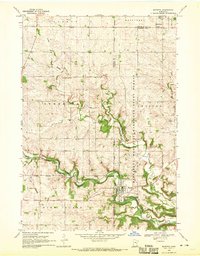 1968 Mazeppa1970 Print · USGSThe river valley at Mazeppa and Bellechester is captured here during the late sixties, showing the transition from rail to road. You can trace the Old Railroad Grade along the North Fork Zumbro River or locate rural landmarks like Grace Ch and the local Townhall.2 unique versions available
 - 1972 Map of Plainview, 1975 Print
 1972 Plainview1975 Print · USGSWabasha County agricultural and forest lands are documented here in the early 1970s, showcasing the region's rail and river connections. Researchers can trace local heritage through sites like St Joachim Cem and the Chicago and North Western rail line.
 - 1972 Map of Zumbro Lake, 1975 Print
 1972 Zumbro Lake1975 Print · USGSThe Zumbro River valley in the early seventies shows a transition between wooded state forest land and the steady agricultural grids of Olmsted County. Researchers can trace riverside developments at Cedar Beach, find the Woodville Chapel, or locate rural burials at Farm Hill Cem.2 unique versions available
 - 1972 Map of Plainview SW, 1975 Print
 1972 Plainview SW1975 Print · USGSSoutheast Minnesota in the early seventies reveals a landscape of deep river valleys and high agricultural plateaus. Researchers can trace rural life through sites like St Pauls Ch, Little Valley Cem, and the wooded stretches of Carley State Park.2 unique versions available
 - 1972 Map of Beaver, 1975 Print
 1972 Beaver1975 Print · USGSSoutheast Minnesota's bluff country is captured here in the early seventies, showing the junction of the Whitewater River and Beaver Creek. Genealogists can locate several rural burial sites, including Beaver Cem and Hoosier Ridge Cem, along with the Hoosier Ridge Ch.2 unique versions available
 - 1972 Map of Chester, 1975 Print
 1972 Chester1975 Print · USGSOlmsted County’s rural townships are captured here in the early seventies, showing a landscape defined by small rail stops and upland forests. Researchers can locate the Haverhill Sch, trace the Chicago and North Western rail line, or find family plots at Haverhill Cem and Oak Hill Cem.
 - 1972 Map of Millville, 1975 Print
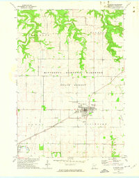
 1972 Millville1975 Print · USGSThe Zumbro River valley and its surrounding plateaus appear here in the early 1970s, showing a landscape of river towns and high-ground farming. Genealogists and local historians can trace small communities like Millville and Bremen, or locate rural landmarks such as Oakwood Ch and Pleasant Prairie Cem.
Showing maps 1-25 of 128
Top cities of Wabasha County
- Lake City historical maps
- Plainview historical maps
- Wabasha historical maps
- Elgin historical maps
- Mazeppa historical maps
- Kellogg historical maps
See more
Frequently asked questions
- What are the different types of historical maps available for Wabasha County?
- What is the oldest map of Wabasha County?
- Where can I purchase historical maps of Wabasha County for my home or office?
- Where can I download high-res historical maps of Wabasha County?
- Are there historical topographic maps available for Wabasha County?
- Is there historical aerial imagery available for Wabasha County?
- Where are historical maps of Wabasha County sourced from?