1910s Maps of Wilkin County, Minnesota
Explore 2 historic maps of Wilkin County from the 1910s. These maps offer a rare glimpse into what life looked like during the 1910s — showing old roads, neighborhoods, homes, and landmarks that have changed or disappeared over time.
Whether you're researching your family's past, planning a metal detecting trip, or studying how Wilkin County's landscape evolved across the 1910s, these high-resolution maps are a powerful tool for exploring the history of this region.
- Focus on a specific era: All maps on this page are from the 1910s, giving you a focused view of this time period.
- See what’s changed: Compare century-old streets, trails, and buildings to today's modern landscape using overlays and satellite layers.
- Research with precision: Use these maps for genealogy, historical research, land use analysis, or educational projects.
- View, download, or print: Maps are fully viewable online in high resolution, and can be downloaded or printed for your own records.
Start exploring Wilkin County's history through authentic maps from the 1910s. This is your window into the past.
Wilkin County, MN maps
(2)- 1919 Map of Rothsay
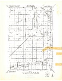 1919 Rothsay1919 Print · USGSRailroad-driven growth on the Wilkin and Otter Tail border is captured here at the end of the Great War. Genealogists can locate family-run grain operations like the Everdell elevator-slender or local landmarks such as the Foxhome Sch. Ho. Cupola and Manston School.
 - 1919 Map of Barnesville, 1943 Print
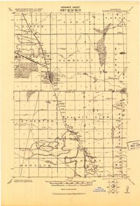 1919 Barnesville1943 Print · USGSThe Red River Valley's agricultural and rail infrastructure is meticulously detailed in this early twentieth-century military survey. Genealogists and historians can locate numerous rural schoolhouses and industrial landmarks like the Barnesville tall Elevator and the Lawndale Elevator.
End of results
Showing maps 1-2 of 2
Top cities of Wilkin County
- Breckenridge historical maps
- Campbell historical maps
- Foxhome historical maps
- Wolverton historical maps
- Kent historical maps
- Nashua historical maps
See more
Frequently asked questions
- What are the different types of historical maps available for Wilkin County?
- What is the oldest map of Wilkin County?
- Where can I purchase historical maps of Wilkin County for my home or office?
- Where can I download high-res historical maps of Wilkin County?
- Are there historical topographic maps available for Wilkin County?
- Is there historical aerial imagery available for Wilkin County?
- Where are historical maps of Wilkin County sourced from?