1980s Maps of Wilkin County, Minnesota
Explore 15 historic maps of Wilkin County from the 1980s. These maps offer a rare glimpse into what life looked like during the 1980s — showing old roads, neighborhoods, homes, and landmarks that have changed or disappeared over time.
Whether you're researching your family's past, planning a metal detecting trip, or studying how Wilkin County's landscape evolved across the 1980s, these high-resolution maps are a powerful tool for exploring the history of this region.
- Focus on a specific era: All maps on this page are from the 1980s, giving you a focused view of this time period.
- See what’s changed: Compare century-old streets, trails, and buildings to today's modern landscape using overlays and satellite layers.
- Research with precision: Use these maps for genealogy, historical research, land use analysis, or educational projects.
- View, download, or print: Maps are fully viewable online in high resolution, and can be downloaded or printed for your own records.
Start exploring Wilkin County's history through authentic maps from the 1980s. This is your window into the past.
Wilkin County, MN maps
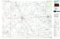
(15)- 1981 Map of Barnesville
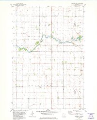
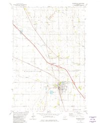 1981 Barnesville1981 Print · USGSThe Clay and Wilkin county line near Barnesville was a hub of rail activity and prairie agriculture in the early 1980s. Researchers can locate family landmarks like Rosemound Cem, St Marys Ch, and the waters of Blue Eagle Lake.
 - 1981 Map of Lawndale
 1981 Lawndale1981 Print · USGSWilkin and Otter Tail Counties are shown in the early eighties as a landscape of prairie agriculture and managed wetlands. Researchers can trace the Burlington Northern rail line through Lawndale and locate the Little Bethany Ch and Prairie View Cem.
 - 1981 Map of Campbell
 1981 Campbell1981 Print · USGSWilkin and Traverse counties are captured here in the early eighties as a hub of rail-dependent agriculture and intricate water management. Researchers can trace the dual rail lines serving Campbell and Tenney or locate the Cem along the winding Rabbit River.
 - 1981 Map of Rothsay NW
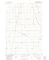
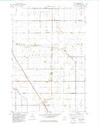
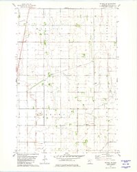 1981 Rothsay NW1981 Print · USGSThe rural prairie of Wilkin County is captured here in the early eighties, showing a landscape defined by township grids and drainage engineering. Researchers can locate family farmsteads and local landmarks like Townhall, Manston Cem, and Meadows Cem.
 - 1981 Map of Barnesville SW
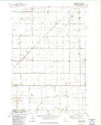
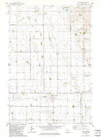
 1981 Barnesville SW1981 Print · USGSWilkin County in the early eighties shows a meticulously organized rural landscape defined by conservation and transport. Genealogists and historians can trace property lines through townships like Tanberg and Manston or locate local landmarks like the Townhall and Burlington Northern railroad.
 - 1981 Map of Everdell
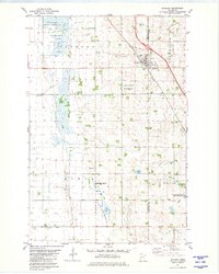
 1981 Everdell1981 Print · USGSWilkin County agriculture and water management are on full display in this early 1980s survey. Genealogists and historians can trace the rail siding at Everdell, the township lines of Nilsen, and the remote Yaggie Landing Strip.
 - 1981 Map of Doran
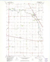
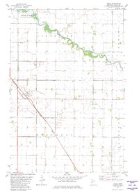 1981 Doran1981 Print · USGSWilkin County in the early eighties shows a meticulously drained prairie landscape centered on the village of Doran. Genealogists and historians can trace the rail corridor of the Burlington Northern and find local landmarks such as Sticklestad Ch and the winding Otter Tail River.
 - 1981 Map of Rothsay
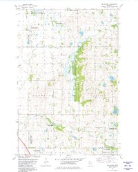
 1981 Rothsay1981 Print · USGSRothsay and the surrounding prairie were deeply integrated with conservation and the railroad in the early eighties. Genealogists and local historians can locate several burial grounds like German Cem and Hamar Cem, or trace the tracks of the Burlington Northern.
 - 1981 Map of Campbell NE
 1981 Campbell NE1981 Print · USGSWilkin and Otter Tail counties meet along the river in the early eighties, showcasing a landscape defined by prairie farming and water management. Researchers can locate family roots at Vukku Ch Cem or trace the civic history of Bradford and the Townhall.
 - 1981 Map of Foxhome
 1981 Foxhome1981 Print · USGSWilkin and Otter Tail counties meet in this early 1980s survey of the Minnesota prairie, showing the village of Foxhome and its rail-line layout. Genealogists can trace local landmarks like Burau Cem, the Townhall, and the specialized National Waterfowl Production Area.
 - 1981 Map of Tintah, 1982 Print
 1981 Tintah1982 Print · USGSThe rail-and-river landscape of the Red River Valley comes into focus in this early 1980s survey of Traverse and Wilkin counties. Genealogists and rail historians can trace the convergence of the Soo Line and Burlington Northern near Tintah and Nashua.
 - 1981 Map of Big Slough, 1982 Print
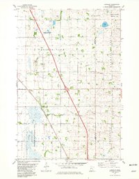
 1981 Big Slough1982 Print · USGSClay and Wilkin counties are shown in the early 1980s as a vital network of wetlands and conservation lands. Researchers can trace land use patterns through numerous Gravel Pits, rural landmarks like Gran Ch, and the waters of Whisky Creek.
 - 1985 Map of Fargo
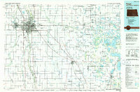 1985 Fargo1985 Print · USGSThe Red River Valley and the Minnesota lake country meet in this mid-1980s survey of the Fargo-Moorhead border region. Genealogists and researchers can trace the Burlington Northern rail corridors and find rural communities like Pelican Rapids, Sabin, and Dilworth.2 unique versions available
 - 1985 Map of Wahpeton, 1986 Print
 1985 Wahpeton1986 Print · USGSThe Red River Valley and Minnesota lake country meet in the mid-eighties at the border towns of Wahpeton and Breckenridge. Genealogists and historians can trace the rail lines of the Burlington Northern through settlements like Abercrombie and Hankinson, or locate legacy sites like Fort Abercrombie State Park.2 unique versions available
 - 1989 Map of Fargo, 1990 Print
 1989 Fargo1990 Print · USGSThe Red River Valley at the end of the eighties shows a landscape of flourishing university towns and vital rail corridors. Researchers can trace family roots through Riverside Cem, find early campus layouts for North Dakota State University, or follow the Soo Line Railroad through West Fargo.
End of results
Showing maps 1-15 of 15
Top cities of Wilkin County
- Breckenridge historical maps
- Campbell historical maps
- Foxhome historical maps
- Wolverton historical maps
- Kent historical maps
- Nashua historical maps
See more
Frequently asked questions
- What are the different types of historical maps available for Wilkin County?
- What is the oldest map of Wilkin County?
- Where can I purchase historical maps of Wilkin County for my home or office?
- Where can I download high-res historical maps of Wilkin County?
- Are there historical topographic maps available for Wilkin County?
- Is there historical aerial imagery available for Wilkin County?
- Where are historical maps of Wilkin County sourced from?