1960s Maps of Wilkin County, Minnesota
Explore 6 historic maps of Wilkin County from the 1960s. These maps offer a rare glimpse into what life looked like during the 1960s — showing old roads, neighborhoods, homes, and landmarks that have changed or disappeared over time.
Whether you're researching your family's past, planning a metal detecting trip, or studying how Wilkin County's landscape evolved across the 1960s, these high-resolution maps are a powerful tool for exploring the history of this region.
- Focus on a specific era: All maps on this page are from the 1960s, giving you a focused view of this time period.
- See what’s changed: Compare century-old streets, trails, and buildings to today's modern landscape using overlays and satellite layers.
- Research with precision: Use these maps for genealogy, historical research, land use analysis, or educational projects.
- View, download, or print: Maps are fully viewable online in high resolution, and can be downloaded or printed for your own records.
Start exploring Wilkin County's history through authentic maps from the 1960s. This is your window into the past.
Wilkin County, MN maps
(6)- 1964 Map of Dwight, 1966 Print
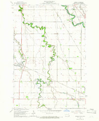 1964 Dwight1966 Print · USGSThe Red River Valley landscape in the mid-1960s highlights the agricultural and spiritual roots of the North Dakota borderlands. Researchers can trace family history at St Josephs Cemetery or locate local landmarks like the Carmelite Monastery and Brushvale.3 unique versions available
 - 1964 Map of Baker, 1966 Print
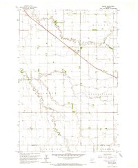 1964 Baker1966 Print · USGSClay County's agricultural heartland is documented here in the mid-sixties, centered on the rail-side settlement of Baker. Researchers can trace the path of the Great Northern railroad and the winding courses of Whisky Creek and the South Branch Buffalo River.3 unique versions available
 - 1964 Map of Wahpeton, 1966 Print
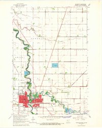 1964 Wahpeton1966 Print · USGSThe Red River valley thrived as a vital rail and educational hub in the mid-sixties, where North Dakota and Minnesota met at the water's edge. Genealogists and researchers can trace the Wahpeton Indian Sch, the St Marys Cem, and several historic Great Northern rail lines.3 unique versions available
 - 1964 Map of Comstock, 1966 Print
 1964 Comstock1966 Print · USGSThe Red River Valley prairie in the mid-sixties shows a landscape shaped by the Great Northern rail line and complex drainage. Genealogists can locate the Comstock Cem and the small siding at Rustad along the Iron Horse route.
 - 1966 Map of Wolverton SE, 1967 Print
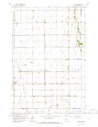
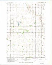 1966 Wolverton SE1967 Print · USGSWilkin County's prairie townships were meticulously organized by drainage and aviation in the mid-1960s. Genealogists and local historians can locate farmstead footprints and landmarks like Deerhorn Cem, the Deerhorn River, and the regional Landing Field.
 - 1966 Map of Wolverton, 1967 Print
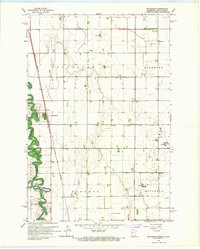 1966 Wolverton1967 Print · USGSThe Red River valley at the Minnesota-North Dakota border is captured here in the mid-sixties, showing a landscape defined by rail and river. Researchers can trace the Great Northern rail corridor through Wolverton or locate family sites near Schmitt Cem and Wolverton Cem.
End of results
Showing maps 1-6 of 6
Top cities of Wilkin County
- Breckenridge historical maps
- Campbell historical maps
- Foxhome historical maps
- Wolverton historical maps
- Kent historical maps
- Nashua historical maps
See more
Frequently asked questions
- What are the different types of historical maps available for Wilkin County?
- What is the oldest map of Wilkin County?
- Where can I purchase historical maps of Wilkin County for my home or office?
- Where can I download high-res historical maps of Wilkin County?
- Are there historical topographic maps available for Wilkin County?
- Is there historical aerial imagery available for Wilkin County?
- Where are historical maps of Wilkin County sourced from?