1960s Maps of Mound Bayou, Mississippi
Explore 3 historic maps of Mound Bayou from the 1960s. These maps offer a rare glimpse into what life looked like during the 1960s — showing old roads, neighborhoods, homes, and landmarks that have changed or disappeared over time.
Whether you're researching your family's past, planning a metal detecting trip, or studying how Mound Bayou's landscape evolved across the 1960s, these high-resolution maps are a powerful tool for exploring the history of this region.
- Focus on a specific era: All maps on this page are from the 1960s, giving you a focused view of this time period.
- See what’s changed: Compare century-old streets, trails, and buildings to today's modern landscape using overlays and satellite layers.
- Research with precision: Use these maps for genealogy, historical research, land use analysis, or educational projects.
- View, download, or print: Maps are fully viewable online in high resolution, and can be downloaded or printed for your own records.
Start exploring Mound Bayou's history through authentic maps from the 1960s. This is your window into the past.
Mound Bayou, MS maps
(3)- 1966 Map of Merigold, 1967 Print
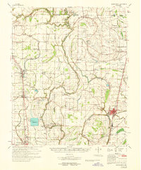
 1966 Merigold1967 Print · USGSThe Bolivar County plantation lands of the mid-1960s are captured here along the Illinois Central rail line. Genealogists and local historians can trace family landmarks like Jerusalem Ch, Smith Cem, and the prominent Indian Mound.
 - 1966 Map of Mound Bayou, 1967 Print
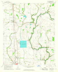
 1966 Mound Bayou1967 Print · USGSMississippi Delta life in the mid-sixties centers on the historic town of Mound Bayou and the Illinois Central tracks. Trace a landscape of country churches and cemeteries like Bradford Chapel, Wander Home Ch, and New Hope Cem.2 unique versions available
 - 1968 Map of Mound Bayou
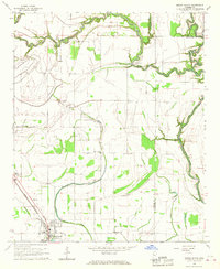
 1968 Mound Bayou1968 Print · USGSThe Mississippi Delta's historic settlements and expansive agricultural lands are detailed here during the late sixties. Researchers can trace family roots through dozens of local landmarks like Mound Bayou, Indian Mounds, and the State Penal Farm.
End of results
Showing maps 1-3 of 3
Top cities near Mound Bayou
- Cleveland historical maps
- Ruleville historical maps
- Shelby historical maps
- Drew historical maps
- Boyle historical maps
- Merigold historical maps
See more
Frequently asked questions
- What are the different types of historical maps available for Mound Bayou?
- What is the oldest map of Mound Bayou?
- Where can I purchase historical maps of Mound Bayou for my home or office?
- Where can I download high-res historical maps of Mound Bayou?
- Are there historical topographic maps available for Mound Bayou?
- Is there historical aerial imagery available for Mound Bayou?
- Where are historical maps of Mound Bayou sourced from?