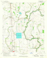
1966 Map of Merigold
USGS Topo · Published 1967About this map
The Illinois Central corridor forms the spine of this Mississippi Delta landscape, connecting the agricultural hubs of Mound Bayou, Merigold, Renova, and the northern outskirts of Cleveland. This mid-1960s survey illustrates a rural economy transitioning from traditional farming toward specialized aquaculture, evidenced by the numerous Fish Farm operations scattered between Mound Bayou (the watercourse) and Lead Bayou. The terrain is punctuated by significant cultural sites, including a prominent Indian Mound and several cemeteries that serve as vital genealogical markers for the region, such as Lampton Chapel Cem and Indian Mounds Cem.
Find a feature on this map
48 named features on this map. Tap any name to fly to it.
Don’t see what you’re looking for? This feature index may not catch every label — zoom into the map to look around manually.
Map Details
Editions of this 1966 Merigold Map
This is the sole edition of this map. No revisions or reprints were ever made.
Other maps of this area

1931 · Drew
USGS Topo · 1:48,000

1934 · Cleveland
USGS Topo · 1:62,500

1935 · Mound Bayou
USGS Topo · 1:62,500

1939 · Pace
USGS Topo · 1:62,500

1939 · Choctaw
USGS Topo · 1:62,500

1940 · Cleveland
USGS Topo · 1:62,500

1953 · Greenwood
USGS Topo · 1:250,000

1956 · Greenwood
USGS Topo · 1:250,000

1966 · Cleveland
USGS Topo · 1:24,000
1966 · Drew
USGS Topo · 1:24,000