1970s Maps of Grenada County, Mississippi
Explore 4 historic maps of Grenada County from the 1970s. These maps offer a rare glimpse into what life looked like during the 1970s — showing old roads, neighborhoods, homes, and landmarks that have changed or disappeared over time.
Whether you're researching your family's past, planning a metal detecting trip, or studying how Grenada County's landscape evolved across the 1970s, these high-resolution maps are a powerful tool for exploring the history of this region.
- Focus on a specific era: All maps on this page are from the 1970s, giving you a focused view of this time period.
- See what’s changed: Compare century-old streets, trails, and buildings to today's modern landscape using overlays and satellite layers.
- Research with precision: Use these maps for genealogy, historical research, land use analysis, or educational projects.
- View, download, or print: Maps are fully viewable online in high resolution, and can be downloaded or printed for your own records.
Start exploring Grenada County's history through authentic maps from the 1970s. This is your window into the past.
Grenada County, MS maps
(4)- 1974 Map of Philipp SE, 1975 Print
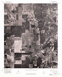 1974 Philipp SE1975 Print · USGSTallahatchie County is captured in the mid-1970s as agricultural fields give way to the wooded bluffs near Cascilla. Genealogists and local historians can trace exact farm clearings, rural road networks, and the sharp boundary between timber and tillage.
 - 1974 Map of Greenwood NW, 1975 Print
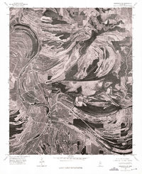 1974 Greenwood NW1975 Print · USGSThe Mississippi Delta's intricate river systems dominate this mid-seventies aerial perspective of Leflore County. Genealogists and researchers can trace the settlement patterns around MONEY and the winding course of the Tallahatchie and Yalobusha River.
 - 1974 Map of Greenwood NE, 1975 Print
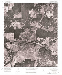 1974 Greenwood NE1975 Print · USGSThe Mississippi Delta meets the hills in the mid-1970s, showcasing a landscape of river bends and rural clearings. Genealogists and land researchers can trace the settlement at Avalon and the winding course of the Yalobusha River.
 - 1974 Map of Philipp SW, 1975 Print
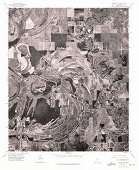 1974 Philipp SW1975 Print · USGSThe Mississippi Delta's alluvial landscape comes into focus in the mid-1970s, showing the deep agricultural roots of the region. Researchers can trace the winding course of the Tallahatchie River and its impact on the settlement patterns near Philipp.
End of results
Showing maps 1-4 of 4
Top cities of Grenada County
Frequently asked questions
- What are the different types of historical maps available for Grenada County?
- What is the oldest map of Grenada County?
- Where can I purchase historical maps of Grenada County for my home or office?
- Where can I download high-res historical maps of Grenada County?
- Are there historical topographic maps available for Grenada County?
- Is there historical aerial imagery available for Grenada County?
- Where are historical maps of Grenada County sourced from?