1980s Maps of Grenada County, Mississippi
Explore 17 historic maps of Grenada County from the 1980s. These maps offer a rare glimpse into what life looked like during the 1980s — showing old roads, neighborhoods, homes, and landmarks that have changed or disappeared over time.
Whether you're researching your family's past, planning a metal detecting trip, or studying how Grenada County's landscape evolved across the 1980s, these high-resolution maps are a powerful tool for exploring the history of this region.
- Focus on a specific era: All maps on this page are from the 1980s, giving you a focused view of this time period.
- See what’s changed: Compare century-old streets, trails, and buildings to today's modern landscape using overlays and satellite layers.
- Research with precision: Use these maps for genealogy, historical research, land use analysis, or educational projects.
- View, download, or print: Maps are fully viewable online in high resolution, and can be downloaded or printed for your own records.
Start exploring Grenada County's history through authentic maps from the 1980s. This is your window into the past.
Grenada County, MS maps
(17)- 1981 Map of Cascilla, 1982 Print
 1981 Cascilla1982 Print · USGSThe transition from the Mississippi Delta to the eastern hills is captured here in the early eighties. Researchers can locate family landmarks such as Oxberry Cem, McClennen Grove Ch, and the rural landing at La Belle Landing Field.
 - 1981 Map of Philipp, 1982 Print
 1981 Philipp1982 Print · USGSThe Mississippi Delta's winding waterways and rural settlements come into focus in the early 1980s. Genealogists can trace family sites at Eagle Plantation, Philipp, and several country churches like Jonas Chapel or Mt Calvary Ch.
 - 1982 Map of Avalon
 1982 Avalon1982 Print · USGSGrenada and Carroll County landscapes in the early eighties show a world of riverbottom settlements and country churches near the Yalobusha River. Genealogists can trace family landmarks like Union Grove Ch, St James Cem, and the community at Avalon.
 - 1982 Map of Money
 1982 Money1982 Print · USGSLeflore County in the early eighties is defined here by the winding Tallahatchie River and the small communities along the Illinois Central Gulf railroad. Researchers can locate family landmarks like Eagle Plantation Cem, Hayward Chapel, and the riverfront at Peebles Landing.
 - 1983 Map of Tie Plant
 1983 Tie Plant1983 Print · USGSRailroad history and rural community life intersect in 1980s Mississippi where three counties meet. Genealogists can trace family names at Old Salem Cem and Wesley Chapel or follow the Illinois Central Gulf corridor through Tie Plant.
 - 1983 Map of Jefferson
 1983 Jefferson1983 Print · USGSThe Grenada and Carroll County borderlands are captured here in the early eighties, showcasing a region defined by its creeks and country churches. Genealogists can trace family roots through numerous sites like Emmons Cem, Liberty Ch, and the settlement of Jefferson.
 - 1983 Map of Tillatoba
 1983 Tillatoba1983 Print · USGSYalobusha and Tallahatchie counties are captured here in the early eighties as a network of rural creek-side communities. Family historians can trace deep roots through local landmarks like Chestnut Grove Cem, the Illinois Central Gulf railroad, and Rosebloom.
 - 1983 Map of Greenwood
 1983 Greenwood1983 Print · USGSThe Mississippi Delta in the early eighties shows a landscape of rail-connected towns and vast river systems. Genealogists and historians can trace family roots in towns like Mound Bayou, Ruleville, and the grounds of Mississippi Valley State University.
 - 1983 Map of Duck Hill
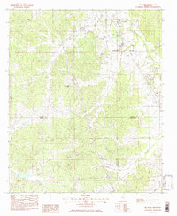
 1983 Duck Hill1983 Print · USGSThe town of Duck Hill and the surrounding hills of Montgomery and Grenada Counties are captured here in the early 1980s. Researchers can trace the vast boundaries of the Camp Mc Cain Military Reservation or locate family sites near Bethlehem Cem and Mt Pisgah Ch.2 unique versions available
 - 1983 Map of Grenada, 1984 Print
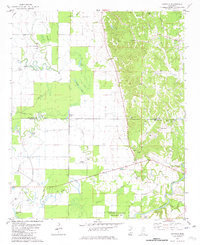
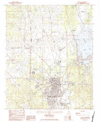 1983 Grenada1984 Print · USGSGrenada and the Yalobusha River valley are shown here in the early eighties as the reservoir's impact on the local landscape was fully established. Genealogists and local historians can trace family sites at Barksdale Cem or Jones Chapel, and explore the rail-linked history of Memphis Junction.
 - 1983 Map of Gore Springs, 1984 Print
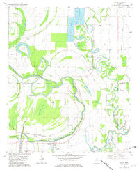
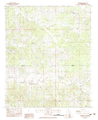
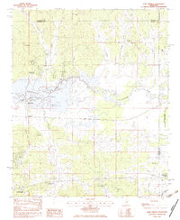 1983 Gore Springs1984 Print · USGSGrenada and Yalobusha counties are captured in the early 1980s as the waters of Grenada Lake shape the local landscape. Researchers can locate family landmarks such as Parker Cem, Mt Nebo Ch, and the community of Gore Springs.
 - 1983 Map of Holcomb, 1984 Print
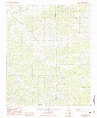
 1983 Holcomb1984 Print · USGSHolcomb and the surrounding river country are captured here in the early eighties as the community transitioned into the modern era. Genealogists can trace family footprints across several rural landmarks, including Tascohomo Cem, Jackson Chapel, and the river landing at Howard.
 - 1983 Map of Sweatman, 1984 Print
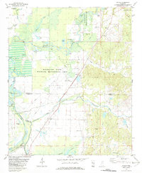
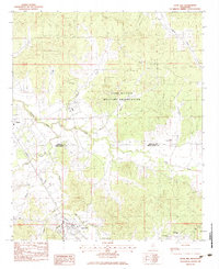
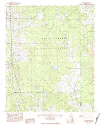
 1983 Sweatman1984 Print · USGSNorth-central Mississippi rural life in the early eighties is preserved here at the crossroads of four counties. Genealogists can trace family names and early congregations at Wells Cem, Blackjack Ch, and the settlement of Sweatman.
 - 1983 Map of Kincaid, 1984 Print
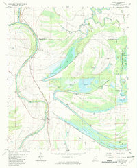
 1983 Kincaid1984 Print · USGSGrenada Lake and its surrounding state parks define the local landscape during the early eighties. Genealogists can locate numerous family burial grounds and rural congregations, including Bob Quarters Cem, Rohnsville Ch, and Bunton Ch.
 - 1983 Map of Scobey, 1984 Print
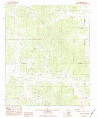
 1983 Scobey1984 Print · USGSYalobusha and Grenada Counties come alive in this early 1980s survey of the Mississippi forest lands. Genealogists and local historians can trace family roots around Scobey, Simmons, and the Jehovah Ch or follow the path of the Illinois Central Gulf railroad.
 - 1984 Map of West Point
 1984 West Point1984 Print · USGSNorth-Central Mississippi in the mid-eighties shows a landscape defined by massive water management projects and dense timberlands. Researchers can trace the legacy of rural settlements like Geeslin Corner or the rail corridors of the Illinois Central Gulf RR near Grenada Lake.3 unique versions available
 - 1984 Map of Grenada, 1990 Print
 1984 Grenada1990 Print · USGSNorth Central Mississippi’s river valleys and conservation lands are captured here in the mid-1980s. Researchers can trace the sprawling Camp Mc Cain, the Illinois Central Gulf rail line, and the historic Treaty Boundary.
End of results
Showing maps 1-17 of 17
Top cities of Grenada County
Frequently asked questions
- What are the different types of historical maps available for Grenada County?
- What is the oldest map of Grenada County?
- Where can I purchase historical maps of Grenada County for my home or office?
- Where can I download high-res historical maps of Grenada County?
- Are there historical topographic maps available for Grenada County?
- Is there historical aerial imagery available for Grenada County?
- Where are historical maps of Grenada County sourced from?