1940s Maps of Humphreys County, Mississippi
Explore 3 historic maps of Humphreys County from the 1940s. These maps offer a rare glimpse into what life looked like during the 1940s — showing old roads, neighborhoods, homes, and landmarks that have changed or disappeared over time.
Whether you're researching your family's past, planning a metal detecting trip, or studying how Humphreys County's landscape evolved across the 1940s, these high-resolution maps are a powerful tool for exploring the history of this region.
- Focus on a specific era: All maps on this page are from the 1940s, giving you a focused view of this time period.
- See what’s changed: Compare century-old streets, trails, and buildings to today's modern landscape using overlays and satellite layers.
- Research with precision: Use these maps for genealogy, historical research, land use analysis, or educational projects.
- View, download, or print: Maps are fully viewable online in high resolution, and can be downloaded or printed for your own records.
Start exploring Humphreys County's history through authentic maps from the 1940s. This is your window into the past.
Humphreys County, MS maps
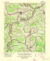
(3)- 1940 Map of Auter, 1941 Print
 1940 Auter1941 Print · USGSThe Mississippi Delta in the early 1940s is captured here as a world of river landings and plantation agriculture along the Big Sunflower River. Genealogists and researchers can trace family landmarks at Hard Cash, Midnight, and Daybreak Plantation.
 - 1940 Map of Baird, 1942 Print
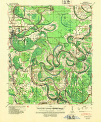
 1940 Baird1942 Print · USGSThe Mississippi Delta's intricate river and rail economy is on full display during the early 1940s. Genealogists and historians can trace family roots through specific landmarks like Price School, Heard Ferry, and the many small settlements like Baird and Inverness.
 - 1940 Map of Mileston, 1953 Print
 1940 Mileston1953 Print · USGSThe Mississippi Delta's winding waterways and rail-linked settlements are captured here just before the mid-century. Genealogists can trace family roots through communities like Mileston and Silver City, or locate specific landmarks like the Good Hope Ch and ancient Indian Mounds.
End of results
Showing maps 1-3 of 3
Top cities of Humphreys County
Frequently asked questions
- What are the different types of historical maps available for Humphreys County?
- What is the oldest map of Humphreys County?
- Where can I purchase historical maps of Humphreys County for my home or office?
- Where can I download high-res historical maps of Humphreys County?
- Are there historical topographic maps available for Humphreys County?
- Is there historical aerial imagery available for Humphreys County?
- Where are historical maps of Humphreys County sourced from?