1980s Maps of Humphreys County, Mississippi
Explore 11 historic maps of Humphreys County from the 1980s. These maps offer a rare glimpse into what life looked like during the 1980s — showing old roads, neighborhoods, homes, and landmarks that have changed or disappeared over time.
Whether you're researching your family's past, planning a metal detecting trip, or studying how Humphreys County's landscape evolved across the 1980s, these high-resolution maps are a powerful tool for exploring the history of this region.
- Focus on a specific era: All maps on this page are from the 1980s, giving you a focused view of this time period.
- See what’s changed: Compare century-old streets, trails, and buildings to today's modern landscape using overlays and satellite layers.
- Research with precision: Use these maps for genealogy, historical research, land use analysis, or educational projects.
- View, download, or print: Maps are fully viewable online in high resolution, and can be downloaded or printed for your own records.
Start exploring Humphreys County's history through authentic maps from the 1980s. This is your window into the past.
Humphreys County, MS maps
(11)- 1982 Map of Silver City
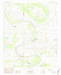
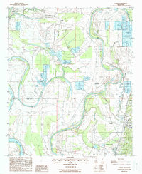
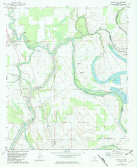 1982 Silver City1982 Print · USGSThe Delta lowlands of Humphreys County appear in the early eighties as a landscape shaped by the winding Yazoo River. Researchers can trace rural lineages through numerous country churches like Burns Chapel and find old footprints along the Old Railroad Grade near Silver City.
 - 1982 Map of Marcella
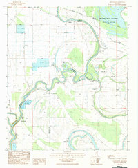
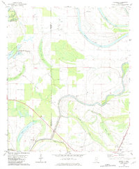 1982 Marcella1982 Print · USGSThe Mississippi Delta's intricate network of bayous and brakes is captured here in the early eighties. Genealogists and historians can trace the Old Indian Treaty Boundary and locate community landmarks like Annie York Ch and Marcella.2 unique versions available
 - 1982 Map of Belzoni, 1983 Print
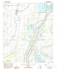
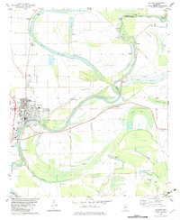 1982 Belzoni1983 Print · USGSThe Yazoo River floodplain in the early 1980s reveals a landscape of delta settlements and agricultural airstrips. Genealogists can trace family roots through numerous sites like Carson Cem, Watson Chapel, and Mt Zion Cem Ch.
 - 1982 Map of Thornton, 1984 Print
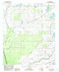
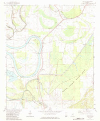 1982 Thornton1984 Print · USGSThe Mississippi Delta river-and-rail corridor is documented here in the early 1980s. Genealogists can trace rural communities through local landmarks like Mileston Sch, Quofaloma, and the Sweet Kingdom Ch near Bee Lake.
 - 1983 Map of Swiftown, 1984 Print
 1983 Swiftown1984 Print · USGSThe Mississippi Delta's intricate oxbows and swamp lands are captured here in the early 1980s, centered on the community of Swiftown. Researchers can trace old property lines along the Indian Treaty Boundary or locate family sites at Graves Cem and White Rock Ch.
 - 1983 Map of Montgomery, 1984 Print
 1983 Montgomery1984 Print · USGSThe Mississippi Delta's river-driven landscape is captured here in the early 1980s, showcasing the winding Yazoo River and its backwaters. Researchers can locate remote rural landmarks like St Pauls Ch No 1 and the riverside settlement of Silent Shade.
 - 1984 Map of Yazoo City
 1984 Yazoo City1984 Print · USGSThe Mississippi Delta and loess bluffs meet in the mid-eighties as the Yazoo River snakes through a dense network of wildlife areas and rail lines. Researchers can trace rural life and drainage history through small communities like Holly Bluff, Mechanicsburg, and Satartia.2 unique versions available
 - 1984 Map of Indianola, 1985 Print
 1984 Indianola1985 Print · USGSThe Mississippi Delta of the mid-1980s reveals a landscape of fertile bottomlands shaped by the Sunflower River and Yazoo River. Researchers can trace the rail-and-river economy through landmarks like Saints College, the Leflore Cemetery, and the Columbus and Greenville Railway.
 - 1988 Map of Louise
 1988 Louise1988 Print · USGSThe Mississippi Delta's agricultural landscape is in full view here during the late 1980s. Genealogists and local historians can trace family locations near Louise or explore the rural environs of Anchorage, Craig, and Potosi along the banks of Silver Creek.
 - 1988 Map of Bayland
 1988 Bayland1988 Print · USGSThe Mississippi Delta bottomlands come alive in the late eighties, showing a landscape of dense woods and complex water management. You can trace the boundaries of the Delta National Forest and locate the settlement at Bayland near Silver Creek.
 - 1988 Map of Carter
 1988 Carter1988 Print · USGSThe Yazoo River Delta in the late 1980s reveals a landscape of alluvial agriculture, levee systems, and river-bend settlements. Trace the rail-and-river history through Yazoo City up to Carter and identify vanished trackside sites like Renshaw.
End of results
Showing maps 1-11 of 11
Top cities of Humphreys County
Frequently asked questions
- What are the different types of historical maps available for Humphreys County?
- What is the oldest map of Humphreys County?
- Where can I purchase historical maps of Humphreys County for my home or office?
- Where can I download high-res historical maps of Humphreys County?
- Are there historical topographic maps available for Humphreys County?
- Is there historical aerial imagery available for Humphreys County?
- Where are historical maps of Humphreys County sourced from?