Old Maps of Leflore County, Mississippi for Academic Research
Study the evolution of Leflore County with 157 high-resolution historic maps. Whether you're teaching, researching, or modeling changes in land use, these maps provide essential visual documentation of urban, environmental, and geographic change.
- Analyze long-term change: Track patterns in development, transportation, and natural features.
- Ideal for environmental or urban studies: Support academic projects with primary historical map data.
- Use in the classroom or lab: Educators and researchers rely on these maps to bring historical context to life.
These maps are a powerful tool for teaching, research, and visualizing how Leflore County has changed over the decades.
Leflore County, MS maps
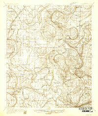
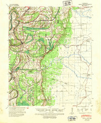
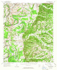
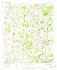
(157)- 1931 Map of Schlater
 1931 Schlater1931 Print · USGSThe Mississippi Delta's complex network of bayous and winding river bends is captured in the early 1930s. Genealogists can trace hundreds of family and community landmarks, from the Rosenwald Sch to small congregations like Thankful Ch and Harts Chapel.
 - 1931 Map of Sumner
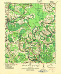
 1931 Sumner1931 Print · USGSTallahatchie County in the early thirties is captured here as a landscape of cotton fields and bayous connected by the Yazoo and Mississippi Valley Railroad. Researchers can locate community centers like Glendora and Sumner, or trace family ties to the Brooks-Rosenwald Sch and Indian Mounds.4 unique versions available
 - 1932 Map of Philipp
 1932 Philipp1932 Print · USGSTallahatchie and Grenada counties in the early 1930s show a landscape shaped by river bends and the expansion of the rail network. Genealogists can trace family roots through numerous country schools and churches like Cowart Sch, Rosenwald Sch, and Jorden Hill Cem.4 unique versions available
 - 1934 Map of Schlater
 1934 Schlater1934 Print · USGSThe Mississippi Delta's winding bayous and rail towns are captured here in the early 1930s, showing a landscape of intense riverfront settlement. Genealogists can trace family-named sites across the floodplains, from Schlater and Sunnyside to the Rosenwald Sch and Rock of Ages Ch.2 unique versions available
 - 1935 Map of Sumner
 1935 Sumner1935 Print · USGSThe Mississippi Delta's intricate river bends and rail towns are captured here in the mid-1930s. Family historians can trace numerous rural sites like Brooks Rosenwald Sch, the State Reservation at Parchman, and the town of Glendora.2 unique versions available
 - 1935 Map of Philipp
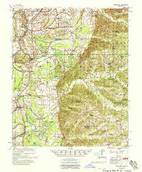
 1935 Philipp1935 Print · USGSThe Mississippi Delta meets the bluff hills in the 1930s, revealing a landscape of winding bayous and railroad-line settlements. Genealogists can locate family landmarks like the Rosenwald Sch, Paynes Cem, and the river town of Locopolis.2 unique versions available
 - 1936 Map of Greenwood
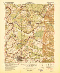
 1936 Greenwood1936 Print · USGSThe Mississippi Delta's river-driven economy is on full display in the mid-1930s as the forks of the Yazoo converge at Greenwood. Genealogists and historians can locate rural landmarks like Geren PO, Little Zion Ch, and the Rosenwald Sch among the oxbows of Tippo Bayou.2 unique versions available
 - 1939 Map of Schlater, 1941 Print
 1939 Schlater1941 Print · USGSThe Mississippi Delta's intricate network of bayous and agricultural communities is captured here in the late 1930s. Genealogists can trace family roots through numerous local landmarks like Rosenwald Sch, Mile Tabernacle, and Rock of Ages Ch.
 - 1939 Map of Sumner, 1943 Print
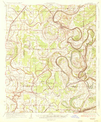
 1939 Sumner1943 Print · USGSTallahatchie County in the late thirties is a landscape of winding river bends and Delta rail towns like Sumner and Glendora. Genealogists and historians can trace numerous rural landmarks, including the Brooks Rosenwald Sch and the ancient Indian Mounds.
 - 1939 Map of Philipp, 1943 Print
 1939 Philipp1943 Print · USGSThe Tallahatchie River Delta is captured here in the decade before major postwar transformation, showing a landscape defined by bayous and small rural hubs. Local researchers can trace family roots through numerous churches and schools like St Mark Ch, Jones Chapel Sch, and the Tallahat Boy Scout Camp.
 - 1940 Map of Seven Pines
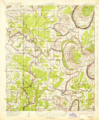
 1940 Seven Pines1940 Print · USGSThe Yazoo River Delta and Carroll County hills meet in the 1940s, showing a landscape of river-bend towns and rural schools. Genealogists can locate family landmarks like Matthews Cem, Smith Chapel, and the riverside rail stop at Sidon.
 - 1940 Map of Greenwood, 1945 Print
 1940 Greenwood1945 Print · USGSThe Mississippi Delta's river-and-rail economy is in full view at the start of the 1940s, where the Yazoo River begins. Genealogists and historians can trace rural communities through the Rosenwald Sch, Ruby Sta, and the historic Malmaison estate.
 - 1940 Map of Mileston, 1953 Print
 1940 Mileston1953 Print · USGSThe Mississippi Delta's winding waterways and rail-linked settlements are captured here just before the mid-century. Genealogists can trace family roots through communities like Mileston and Silver City, or locate specific landmarks like the Good Hope Ch and ancient Indian Mounds.
 - 1953 Map of Greenwood, 1966 Print
 1953 Greenwood1966 Print · USGSThe Mississippi Delta in the mid-fifties is captured here as a thriving network of river towns, railroads, and oxbow lakes. Researchers can trace the legacy of the Illinois Central Railroad and locate landmarks like the State Penal Farm and Greenville Air Force Base.5 unique versions available
 - 1954 Map of Mileston
 1954 Mileston1954 Print · USGSThe Yazoo River Delta in the mid-1950s reveals a landscape shaped by massive flood control projects and deep-rooted river communities. Genealogists can trace family footprints through numerous rural landmarks like Holly Grove Ch & Cem, Jaketown, and the remote settlement of Pluto.
 - 1956 Map of Greenwood
 1956 Greenwood1956 Print · USGSThe Mississippi Delta in the mid-fifties is captured here during a period of significant military and agricultural activity. Researchers can trace the rail lines of the Illinois Central RR, find the Greenville Air Force Base, or locate the State Penal Farm.
 - 1957 Map of Philipp
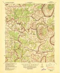
 1957 Philipp1957 Print · USGSThe Tallahatchie River basin in the mid-fifties is a landscape of river cut-offs and rural crossroads settlements. Genealogists can trace family roots at St. Paul Sch Ch & Cem, Philipp, and the Needmore Cem along the Illinois Central line.3 unique versions available
 - 1957 Map of Greenwood
 1957 Greenwood1957 Print · USGSThe Mississippi Delta in the late fifties shows a landscape of river-bend settlements and extensive rail networks. Genealogists can trace family roots at Little Zion Ch & Cem, Money, and the many rural churches like Lanes Chapel or Evergreen Ch.3 unique versions available
 - 1957 Map of Seven Pines, 1965 Print
 1957 Seven Pines1965 Print · USGSThe Yazoo River bottomlands and Carroll County bluffs meet in the late fifties, showing a landscape defined by oxbow lakes and rural railroad towns. Genealogists can trace family names through dozens of upland sites like McMillian Cem and Harmony Ch & Cem.
 - 1958 Map of Seven Pines
 1958 Seven Pines1958 Print · USGSThe Yazoo River Delta meets the Carroll County hills in the late fifties, showcasing a landscape of oxbow lakes and upland ridges. Researchers can locate Indian Mounds, the Greenwood Air Base, and numerous country churches like Shiloh Ch & Cem.
 - 1961 Map of Mossy Lake, 1962 Print
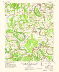 1961 Mossy Lake1962 Print · USGSLeflore County's intricate Delta wetlands and river bends are captured here in the early sixties, showing a landscape of scattered settlements and rural churches. Researchers can trace the Columbus and Greenville rail line through Itta Bena or locate local landmarks like McIntyre Cem and the Indian Mound.3 unique versions available
 - 1961 Map of Schlater, 1963 Print
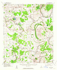 1961 Schlater1963 Print · USGSLeflore County in the early sixties is a landscape of river bends and rail lines before the modern era of consolidation. Genealogists can trace family roots through numerous delta landmarks like Mississippi Vocational College, Shiloh Cem, and Itta Bena.2 unique versions available
 - 1962 Map of Sumner, 1965 Print
 1962 Sumner1965 Print · USGSThe Mississippi Delta in the early sixties remains a landscape of bayous and rails, centered on the Tallahatchie River and its cut-offs. Genealogists can trace family roots through numerous local landmarks like Parchman, Glendora, and the Frierson Chapel.2 unique versions available
 - 1974 Map of Schlater SW, 1975 Print
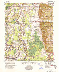
 1974 Schlater SW1975 Print · USGSThe Mississippi Delta's agricultural layout is captured here in the mid-1970s, showing a landscape defined by the winding path of the River. Researchers can trace the evolution of land use and river migration through the distinct oxbow patterns and field boundaries.
 - 1974 Map of Schlater NW, 1975 Print
 1974 Schlater NW1975 Print · USGSThe Mississippi Delta's agricultural grid and the winding course of the Quiver River are captured in this mid-seventies aerial survey. Local historians and land researchers can trace the 1974 boundaries of farmland and drainage systems along the riverbank.
Showing maps 1-25 of 157
Top cities of Leflore County
- Greenwood historical maps
- Itta Bena historical maps
- Sidon historical maps
- Schlater historical maps
- Morgan City historical maps
Frequently asked questions
- What are the different types of historical maps available for Leflore County?
- What is the oldest map of Leflore County?
- Where can I purchase historical maps of Leflore County for my home or office?
- Where can I download high-res historical maps of Leflore County?
- Are there historical topographic maps available for Leflore County?
- Is there historical aerial imagery available for Leflore County?
- Where are historical maps of Leflore County sourced from?