1980s Maps of Leflore County, Mississippi
Explore 22 historic maps of Leflore County from the 1980s. These maps offer a rare glimpse into what life looked like during the 1980s — showing old roads, neighborhoods, homes, and landmarks that have changed or disappeared over time.
Whether you're researching your family's past, planning a metal detecting trip, or studying how Leflore County's landscape evolved across the 1980s, these high-resolution maps are a powerful tool for exploring the history of this region.
- Focus on a specific era: All maps on this page are from the 1980s, giving you a focused view of this time period.
- See what’s changed: Compare century-old streets, trails, and buildings to today's modern landscape using overlays and satellite layers.
- Research with precision: Use these maps for genealogy, historical research, land use analysis, or educational projects.
- View, download, or print: Maps are fully viewable online in high resolution, and can be downloaded or printed for your own records.
Start exploring Leflore County's history through authentic maps from the 1980s. This is your window into the past.
Leflore County, MS maps
(22)- 1981 Map of Philipp, 1982 Print
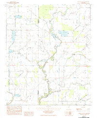
 1981 Philipp1982 Print · USGSThe Mississippi Delta's winding waterways and rural settlements come into focus in the early 1980s. Genealogists can trace family sites at Eagle Plantation, Philipp, and several country churches like Jonas Chapel or Mt Calvary Ch.
 - 1982 Map of Avalon
 1982 Avalon1982 Print · USGSGrenada and Carroll County landscapes in the early eighties show a world of riverbottom settlements and country churches near the Yalobusha River. Genealogists can trace family landmarks like Union Grove Ch, St James Cem, and the community at Avalon.
 - 1982 Map of Money
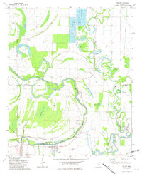
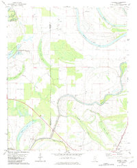
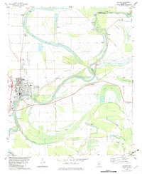
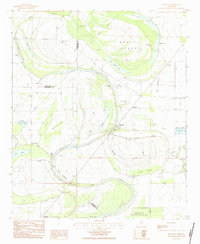
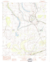
 1982 Money1982 Print · USGSLeflore County in the early eighties is defined here by the winding Tallahatchie River and the small communities along the Illinois Central Gulf railroad. Researchers can locate family landmarks like Eagle Plantation Cem, Hayward Chapel, and the riverfront at Peebles Landing.
 - 1982 Map of Gravel Hill
 1982 Gravel Hill1982 Print · USGSCarroll County settlements and family histories are well-preserved in this 1980s map of the hill country. Genealogists can trace family connections at Smith Chapel Cem, Gravel Hill, and the Sharkey Pate Cem.
 - 1982 Map of Sidon
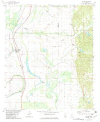
 1982 Sidon1982 Print · USGSThe Yazoo River delta in the early eighties shows a landscape of oxbow lakes and rail-side settlements. Trace family history at Mt Pisgah Cem or locate old landmarks like the Walker Lake Pumping Plant and Rising Sun Sch.
 - 1982 Map of Greenwood
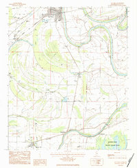
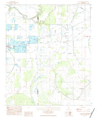
 1982 Greenwood1982 Print · USGSGreenwood and its surrounding delta river junctions are captured here in the early eighties. Genealogists and historians can trace family-named sites like Loggins Cem and Little Zion Ch, or locate landmarks like the Florewood River Plantation Museum.
 - 1982 Map of Marcella
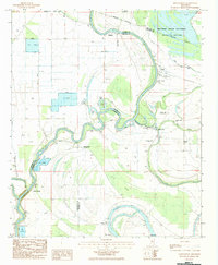
 1982 Marcella1982 Print · USGSThe Mississippi Delta's intricate network of bayous and brakes is captured here in the early eighties. Genealogists and historians can trace the Old Indian Treaty Boundary and locate community landmarks like Annie York Ch and Marcella.2 unique versions available
 - 1982 Map of Cruger
 1982 Cruger1982 Print · USGSThe town of Cruger and the surrounding Mississippi Delta bottomlands are captured here in the early eighties as the rail-and-river economy continued to shape the region. Genealogists and local researchers can locate numerous rural churches and cemeteries, including Beth-el Chapel, Valley View Cem, and the settlement of Oklahoma.
 - 1982 Map of Browning
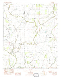
 1982 Browning1982 Print · USGSThe Carroll County hills meet the Delta in the early 1980s, revealing a landscape of family cemeteries and historic Choctaw-linked sites. Genealogists can trace family names at the Greenwood LeFlore Cem or locate rural landmarks like Malmaison and Mitchell Springs Ch.
 - 1982 Map of Belzoni, 1983 Print
 1982 Belzoni1983 Print · USGSThe Yazoo River floodplain in the early 1980s reveals a landscape of delta settlements and agricultural airstrips. Genealogists can trace family roots through numerous sites like Carson Cem, Watson Chapel, and Mt Zion Cem Ch.
 - 1983 Map of Greenwood
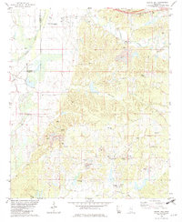
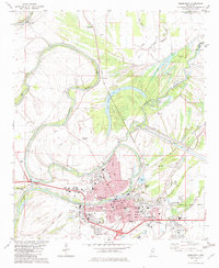
 1983 Greenwood1983 Print · USGSThe Mississippi Delta in the early eighties shows a landscape of rail-connected towns and vast river systems. Genealogists and historians can trace family roots in towns like Mound Bayou, Ruleville, and the grounds of Mississippi Valley State University.
 - 1983 Map of Itta Bena, 1984 Print
 1983 Itta Bena1984 Print · USGSThe Yazoo River bottomlands and the Columbus and Greenville railroad define this Mississippi Delta landscape in the early eighties. Researchers can trace rural lineages through the McIntyre Cem, New Home Ch, and old landings like Sheppardtown.
 - 1983 Map of Brooks, 1984 Print
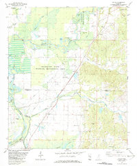
 1983 Brooks1984 Print · USGSThe Mississippi Delta's intersection of Sunflower, Tallahatchie, and Leflore counties shows its agricultural character in the 1980s. Genealogists can locate family sites at Mt Olive Cemetery, Holmes Chapel, and Merry Grove Church.
 - 1983 Map of Schlater, 1984 Print
 1983 Schlater1984 Print · USGSThe Mississippi Delta landscape of the early eighties comes into focus along the winding Tallahatchie River. Researchers can trace old family settlements at Schlater and Highlandale or locate landmarks like Ashland Brake and McNutt Lake.
 - 1983 Map of Bear Gut Bayou, 1984 Print
 1983 Bear Gut Bayou1984 Print · USGSThe Mississippi Delta landscape along the border of Sunflower and Leflore counties is captured here in the early eighties. Genealogists can locate rural landmarks like Pleasant Valley Cem, St Paul Ch, and the winding Quiver River.
 - 1983 Map of Swiftown, 1984 Print
 1983 Swiftown1984 Print · USGSThe Mississippi Delta's intricate oxbows and swamp lands are captured here in the early 1980s, centered on the community of Swiftown. Researchers can trace old property lines along the Indian Treaty Boundary or locate family sites at Graves Cem and White Rock Ch.
 - 1983 Map of Rattlesnake Bayou, 1984 Print
 1983 Rattlesnake Bayou1984 Print · USGSThe Mississippi Delta's intricate river drainage and rural agricultural infrastructure are captured here in the early eighties. Local historians can trace the meandering Quiver River and find landmarks like Cane Lake and the Neal Landing Strip.
 - 1983 Map of Shellmound, 1984 Print
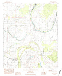
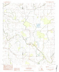
 1983 Shellmound1984 Print · USGSLeflore County during the early eighties shows a Delta landscape defined by the Tallahatchie River and industrial agriculture. Genealogists can trace rural communities through local landmarks like Mt Zion Ch, St Pauls Cem, and the campus of Mississippi Valley State University.
 - 1983 Map of Glendora, 1984 Print
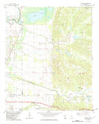
 1983 Glendora1984 Print · USGSThe Tallahatchie River delta in the early 1980s is shown here in detail, from Glendora to Minter City. Researchers can locate Black Bayou Sch, St Marys Cem, and the Illinois Central Gulf rail line.
 - 1983 Map of Colony Town, 1984 Print
 1983 Colony Town1984 Print · USGSThe Mississippi Delta's aquaculture and drainage systems are clearly visible in this early 1980s look at the Sunflower and Leflore county line. Genealogists and historians can locate Colony Town, Old Dominion, and local landmarks like Mt Maria Ch or the Robinson Cem.
 - 1983 Map of Montgomery, 1984 Print
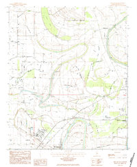
 1983 Montgomery1984 Print · USGSThe Mississippi Delta's river-driven landscape is captured here in the early 1980s, showcasing the winding Yazoo River and its backwaters. Researchers can locate remote rural landmarks like St Pauls Ch No 1 and the riverside settlement of Silent Shade.
 - 1984 Map of Indianola, 1985 Print
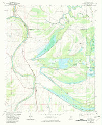
 1984 Indianola1985 Print · USGSThe Mississippi Delta of the mid-1980s reveals a landscape of fertile bottomlands shaped by the Sunflower River and Yazoo River. Researchers can trace the rail-and-river economy through landmarks like Saints College, the Leflore Cemetery, and the Columbus and Greenville Railway.
End of results
Showing maps 1-22 of 22
Top cities of Leflore County
- Greenwood historical maps
- Itta Bena historical maps
- Sidon historical maps
- Schlater historical maps
- Morgan City historical maps
Frequently asked questions
- What are the different types of historical maps available for Leflore County?
- What is the oldest map of Leflore County?
- Where can I purchase historical maps of Leflore County for my home or office?
- Where can I download high-res historical maps of Leflore County?
- Are there historical topographic maps available for Leflore County?
- Is there historical aerial imagery available for Leflore County?
- Where are historical maps of Leflore County sourced from?