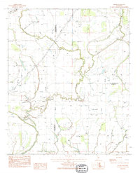
1983 Map of Brooks
USGS Topo · Published 1984About this map
The delta lowlands at the junction of Sunflower, Tallahatchie, and Leflore counties are defined by a complex network of bayous and the winding Quiver River. This early 1980s landscape is anchored by the settlement of Brooks, where the local Brooks Landing Strip and Mt Olive Ch serve the surrounding agricultural community. The map reveals a land heavily managed for water, featuring numerous flumes, levees, and pipelines alongside natural water bodies like Hoard Lake and Horseshoe Brake. Genealogists will find significant value in the distribution of rural burial grounds and places of worship, including Mt Olive Cem, Scott Cem, and Merry Grove Cem, which are scattered throughout the floodplains. The map illustrates how human activity, from irrigation to aviation, has adapted to the seasonal rhythms of the Wild Bill Bayou and Fighting Bayou systems.
Find a feature on this map
27 named features on this map. Tap any name to fly to it.
Don’t see what you’re looking for? This feature index may not catch every label — zoom into the map to look around manually.
Map Details
Editions of this 1983 Brooks Map
This is the sole edition of this map. No revisions or reprints were ever made.
Other maps of this area

1931 · Schlater
USGS Topo · 1:48,000

1931 · Sumner
USGS Topo · 1:48,000

1931 · Drew
USGS Topo · 1:48,000

1934 · Cleveland
USGS Topo · 1:62,500

1934 · Schlater
USGS Topo · 1:62,500

1935 · Sumner
USGS Topo · 1:62,500

1935 · Mound Bayou
USGS Topo · 1:62,500

1939 · Schlater
USGS Topo · 1:62,500

1939 · Sumner
USGS Topo · 1:62,500

1940 · Cleveland
USGS Topo · 1:62,500