1970s Maps of Marion County, Mississippi
Explore 13 historic maps of Marion County from the 1970s. These maps offer a rare glimpse into what life looked like during the 1970s — showing old roads, neighborhoods, homes, and landmarks that have changed or disappeared over time.
Whether you're researching your family's past, planning a metal detecting trip, or studying how Marion County's landscape evolved across the 1970s, these high-resolution maps are a powerful tool for exploring the history of this region.
- Focus on a specific era: All maps on this page are from the 1970s, giving you a focused view of this time period.
- See what’s changed: Compare century-old streets, trails, and buildings to today's modern landscape using overlays and satellite layers.
- Research with precision: Use these maps for genealogy, historical research, land use analysis, or educational projects.
- View, download, or print: Maps are fully viewable online in high resolution, and can be downloaded or printed for your own records.
Start exploring Marion County's history through authentic maps from the 1970s. This is your window into the past.
Marion County, MS maps
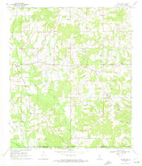
(13)- 1970 Map of Columbia South, 1972 Print
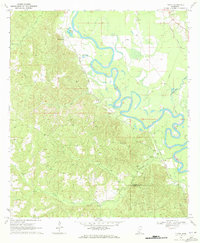
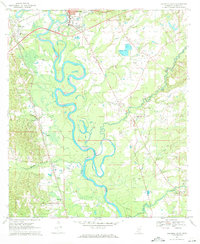 1970 Columbia South1972 Print · USGSMarion County's river-bottom landscape comes alive in the early seventies, centered on the winding Pearl River south of Columbia. Genealogists and local historians can locate early settlements like Foxworth and Pickwick, or trace the grounds of St Paul Ch and Sunflower Ch Cem.2 unique versions available
 - 1970 Map of Sandy Hook NW, 1972 Print
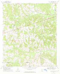 1970 Sandy Hook NW1972 Print · USGSThe rural borderlands of Marion and Walthall Counties are captured here in the early seventies, centered on the community of Foxworth. Genealogists and historians can trace local landmarks like Kokomo Sch, Terrys Chapel, and the Fernwood Columbia and Gulf railroad.3 unique versions available
 - 1970 Map of Kokomo, 1972 Print
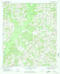 1970 Kokomo1972 Print · USGSThe rural border of Marion and Walthall counties is captured here in the early 1970s, showing a landscape of timber-land settlements and rising energy infrastructure. Researchers can trace family roots through Magees Creek Ch, Boyd Cem, and the community at Kokomo.
 - 1970 Map of Bunker Hill, 1972 Print
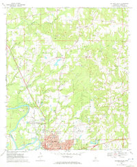
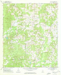 1970 Bunker Hill1972 Print · USGSJefferson Davis and Marion counties appear here during the transition into the 1970s, a period of quiet rural industry and established community life. Genealogists can trace family roots through several local burial grounds and churches, including Old Bassfield Cem, Thompson Chapel Cem, and Shorts Chapel.2 unique versions available
 - 1970 Map of Darbun, 1972 Print
 1970 Darbun1972 Print · USGSSouth Mississippi’s rural crossroads come into focus during the early seventies, where the borders of three counties meet. Researchers can trace family history through a concentration of country churches and burial grounds like Sartinville Ch, Darbun Ch, and Sauls Valley Cem.
 - 1970 Map of Dexter, 1972 Print
 1970 Dexter1972 Print · USGSWalthall County, Mississippi, and Washington Parish, Louisiana, meet in this early 1970s survey of a landscape shaped by petroleum and timber. Genealogists and researchers can locate family sites like Fortenberry Cem and old rural churches such as Centerville Ch and Mt Olive Ch.
 - 1970 Map of Morgantown, 1972 Print
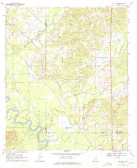
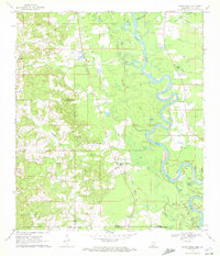
 1970 Morgantown1972 Print · USGSMarion County at the start of the 1970s is a landscape of winding river bends and rural industry centered on the Pearl River. Genealogists and local historians can trace the foundations of communities like Morgantown and White Bluff, as well as rural landmarks like Mt Sinai Ch.
 - 1970 Map of Oak Vale, 1972 Print
 1970 Oak Vale1972 Print · USGSJefferson Davis County and the Pearl River basin are shown here in the early seventies as a hub of rail transit and rural industry. Researchers can trace the Illinois Central railroad through Oak Vale or locate historic sites like Hepzibah Ch and Bourne Cem.2 unique versions available
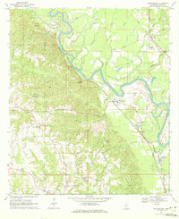
 - 1970 Map of Columbia North, 1972 Print
 1970 Columbia North1972 Print · USGSColumbia was expanding into the Marion County hills during the late sixties, a period of transition between its rail-river roots and modern infrastructure. Researchers can trace family sites at Harmony Ch and Pope Cem or locate the old Drive-in Theater.3 unique versions available
 - 1970 Map of Tilton, 1972 Print
 1970 Tilton1972 Print · USGSLawrence County during the late Vietnam era was defined by the winding Pearl River and its busy rail lines. Genealogists and historians can trace family locations near Robinwood, Chinalee Ch, and the Bozeman Cem.
 - 1970 Map of Sandy Hook, 1972 Print
 1970 Sandy Hook1972 Print · USGSThe Pearl River floodplain at the Mississippi-Louisiana border was a landscape of winding oxbows and rural rail lines during the 1970s. Genealogists can trace family names through numerous burial grounds like Warren Cem and Capp Cem, or locate landmarks such as Sandy Hook and the Gulf Mobile and Ohio railroad.2 unique versions available
 - 1974 Map of Bassfield, 1978 Print
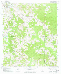 1974 Bassfield1978 Print · USGSJefferson Davis County and the surrounding timberlands appear in the mid-1970s as a landscape of rural churches and family homesteads. Trace the Illinois Central Gulf rail line past Bassfield or locate family sites like McPhail Cem and Raybourn Cem.
 - 1976 Map of Bogalusa NE, 1977 Print
 1976 Bogalusa NE1977 Print · USGSThe timberlands and river bottoms of Washington Parish are captured here in the mid-1970s. Local researchers can trace the rural landscape between Angie and Varnado, including the deep oxbows along the Pearl River.
End of results
Showing maps 1-13 of 13
Top cities of Marion County
Frequently asked questions
- What are the different types of historical maps available for Marion County?
- What is the oldest map of Marion County?
- Where can I purchase historical maps of Marion County for my home or office?
- Where can I download high-res historical maps of Marion County?
- Are there historical topographic maps available for Marion County?
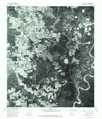
- Is there historical aerial imagery available for Marion County?
- Where are historical maps of Marion County sourced from?