1970s Maps of Rankin County, Mississippi
Explore 6 historic maps of Rankin County from the 1970s. These maps offer a rare glimpse into what life looked like during the 1970s — showing old roads, neighborhoods, homes, and landmarks that have changed or disappeared over time.
Whether you're researching your family's past, planning a metal detecting trip, or studying how Rankin County's landscape evolved across the 1970s, these high-resolution maps are a powerful tool for exploring the history of this region.
- Focus on a specific era: All maps on this page are from the 1970s, giving you a focused view of this time period.
- See what’s changed: Compare century-old streets, trails, and buildings to today's modern landscape using overlays and satellite layers.
- Research with precision: Use these maps for genealogy, historical research, land use analysis, or educational projects.
- View, download, or print: Maps are fully viewable online in high resolution, and can be downloaded or printed for your own records.
Start exploring Rankin County's history through authentic maps from the 1970s. This is your window into the past.
Rankin County, MS maps
(6)- 1971 Map of Florence, 1973 Print
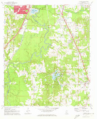 1971 Florence1973 Print · USGSThe Pearl River valley in the early seventies shows the growing connection between Jackson and rural Rankin County. Researchers can trace family history through sites like Smith Cem, Hickory Ridge Ch, and the old crossroads at Frenchs Store.
 - 1971 Map of Whitfield, 1973 Print
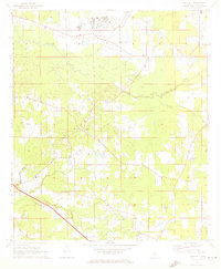 1971 Whitfield1973 Print · USGSRankin County during the early seventies is characterized by large institutional sites and a dense network of rural communities. Genealogists and historians can trace local family life through landmarks like New Hope Ch, Thomasville, and the Mississippi State Hospital.
 - 1971 Map of New Byram, 1973 Print
 1971 New Byram1973 Print · USGSHinds County during the early 1970s shows a landscape of small crossroads and river bends south of Jackson. Genealogists can trace family connections through local landmarks like Spring Ridge Cem and country churches including Mt Salem Ch and Bethesda Ch.
 - 1971 Map of Whites, 1973 Print
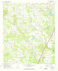
 1971 Whites1973 Print · USGSThe rural borders of Rankin, Simpson, Hinds, and Copiah counties come together here in the early seventies. Researchers can trace the legacy of small communities through landmarks like Sinai, the Gulf Mobile and Ohio railroad, and Mt Zion Ch.2 unique versions available
 - 1971 Map of Terry, 1973 Print
 1971 Terry1973 Print · USGSThe Hinds and Copiah county line is captured in the early seventies, centered on the ILLINOIS CENTRAL GULF railroad. Genealogists can trace local roots through landmarks like Morgans Store, the Terry Academy, and the Benevolent Society Cem.2 unique versions available
 - 1971 Map of Star, 1973 Print
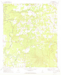
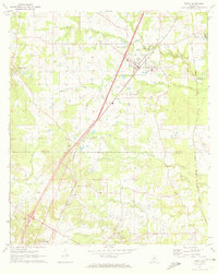
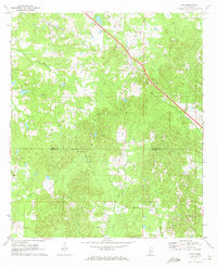 1971 Star1973 Print · USGSThe community of Star and the Illinois Central railroad define this rural landscape in the early seventies. Genealogists can locate family-named sites like Wesleyanna Cem, Enoch Grove Cem, and Mt Salem Ch along the winding banks of Mountain Creek.2 unique versions available
End of results
Showing maps 1-6 of 6
Top cities of Rankin County
- Pearl historical maps
- Brandon historical maps
- Flowood historical maps
- Richland historical maps
- Florence historical maps
- Pelahatchie historical maps
See more
Frequently asked questions
- What are the different types of historical maps available for Rankin County?
- What is the oldest map of Rankin County?
- Where can I purchase historical maps of Rankin County for my home or office?
- Where can I download high-res historical maps of Rankin County?
- Are there historical topographic maps available for Rankin County?
- Is there historical aerial imagery available for Rankin County?
- Where are historical maps of Rankin County sourced from?