1980s Maps of Stone County, Mississippi
Explore 15 historic maps of Stone County from the 1980s. These maps offer a rare glimpse into what life looked like during the 1980s — showing old roads, neighborhoods, homes, and landmarks that have changed or disappeared over time.
Whether you're researching your family's past, planning a metal detecting trip, or studying how Stone County's landscape evolved across the 1980s, these high-resolution maps are a powerful tool for exploring the history of this region.
- Focus on a specific era: All maps on this page are from the 1980s, giving you a focused view of this time period.
- See what’s changed: Compare century-old streets, trails, and buildings to today's modern landscape using overlays and satellite layers.
- Research with precision: Use these maps for genealogy, historical research, land use analysis, or educational projects.
- View, download, or print: Maps are fully viewable online in high resolution, and can be downloaded or printed for your own records.
Start exploring Stone County's history through authentic maps from the 1980s. This is your window into the past.
Stone County, MS maps
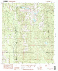
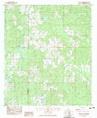
(15)- 1982 Map of Barbara
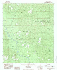 1982 Barbara1982 Print · USGSPerry and Stone Counties are shown in the early eighties as a region of managed timberland and river bottoms. Family historians can locate several rural burials including Fairley Cem and Cooper Cem, or trace the path of Black Creek past Fairley Bridge Landing.
 - 1982 Map of Ramsey Springs
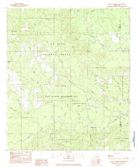 1982 Ramsey Springs1982 Print · USGSSoutheastern Mississippi's piney woods and creek bottoms are documented here in the early eighties. Genealogists can locate family landmarks like Whittington Cem and Moore Cem or trace the Old RR Grade through Ramsey Springs.
 - 1982 Map of Beatrice
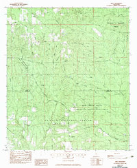
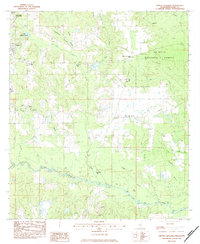
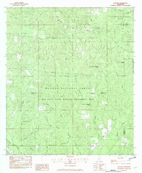 1982 Beatrice1982 Print · USGSStone County and the neighboring pine forests are captured here in the early 1980s as centers of timber and wildlife management. Researchers can trace rural genealogy at Walker Cem and Ramsey Chapel, or locate the old University Lookout Tower and the settlement of Beatrice.
 - 1982 Map of McHenry, 1983 Print
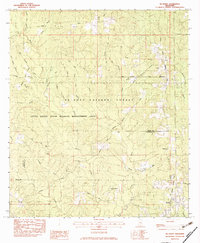 1982 McHenry1983 Print · USGSThe Piney Woods of Stone and Harrison Counties are captured here in the early eighties as the railroad still connected rural timber towns. Genealogists can trace family landmarks like Yellow Fever Cem, Oak Lawn Cem, and the village of McHenry.2 unique versions available
 - 1982 Map of Silver Run, 1983 Print
 1982 Silver Run1983 Print · USGSSouth Mississippi timber and river country comes alive in this early eighties survey, covering the intersection of four counties. Genealogists can locate family landmarks like Ladner Cem and rural centers such as Silver Run or the Old Barth Community Ch.
 - 1982 Map of Airey, 1983 Print
 1982 Airey1983 Print · USGSStone and Harrison Counties are shown in the early eighties as a hub of managed timberlands and wildlife preserves. Researchers can trace rural life through the locations of Airey, Lott Cem, and the winding Tuxachanie Trail.
 - 1983 Map of Bond Pond
 1983 Bond Pond1983 Print · USGSThe woodlands of southern Mississippi are captured here in the early eighties, centered on the intersection of the Perry and Stone county lines. Genealogists can locate several family burial grounds and rural pulpits, including Howard-Breland Cem, Taylor Cem, and Amanda Chapel.
 - 1983 Map of Carnes
 1983 Carnes1983 Print · USGSThe pine forests and creek bottoms of southern Forrest County are captured here in the early eighties. Local researchers can locate family sites including Lee Town Ch, the J E Bounds Mem Cem, and the rural community of Carnes.
 - 1983 Map of Browns Lake
 1983 Browns Lake1983 Print · USGSStone County and Pearl River County shared a rural, creek-ribbed border in the early 1980s. Researchers can locate generational landmarks like Smith Town and several family burial sites including Daugdrill Cem and Seals Cem.
 - 1983 Map of Whites Crossing, 1984 Print
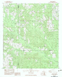
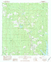
 1983 Whites Crossing1984 Print · USGSStone County in the early eighties reveals a landscape of deep pine woods and quiet rural life centered around the De Soto National Forest. Researchers can locate family roots at Lott Hickman Cem, visit Morning Star Ch, or trace the path of the I C G rail line.
 - 1983 Map of Wiggins, 1984 Print
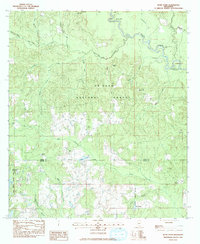
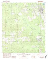 1983 Wiggins1984 Print · USGSStone County settlements thrive along the Illinois Central Gulf rail line in the early eighties. Genealogists and local historians can trace rural roots through numerous sites like Price Memorial Cem, Sweet Beulah Ch, and the Mississippi Gulf Coast Jr College campus.
 - 1983 Map of Bond, 1984 Print
 1983 Bond1984 Print · USGSSouthern Mississippi's timber and gas lands are captured in the early eighties as the industrial and recreational landscape matured. Researchers can locate family sites like Batson Cem and Bo Williams Cem or trace the Illinois Central Gulf rail line through Bond and Fruitland Park.
 - 1984 Map of Mobile
 1984 Mobile1984 Print · USGSMobile and its surrounding Gulf Coast backcountry appear in the mid-eighties as a hub of maritime industry and timber management. Genealogists and historians can trace the development of the riverfront near McDuffie Island or explore rural settlements like Lucedale and Chunchula.
 - 1984 Map of Bogalusa
 1984 Bogalusa1984 Print · USGSThe Pearl River basin on the Louisiana-Mississippi border comes into focus in the mid-1980s, showcasing a landscape of river-bottom swamps and timberlands. Local researchers can trace the growth of Bogalusa and Picayune or find rural landmarks like Macedonia Ch and Wheat Swamp.
 - 1984 Map of Mobile
 1984 Mobile1984 Print · USGSThe Gulf Coast at the height of the mid-eighties shows a landscape of rapid industrial growth and military significance. Researchers can trace the sprawling rail lines of the Illinois Central Gulf RR, locate the NASA Test Facility, or study the barrier island chain from Cat Island to Petit Bois Island.3 unique versions available
End of results
Showing maps 1-15 of 15
Top cities of Stone County
Frequently asked questions
- What are the different types of historical maps available for Stone County?
- What is the oldest map of Stone County?
- Where can I purchase historical maps of Stone County for my home or office?
- Where can I download high-res historical maps of Stone County?
- Are there historical topographic maps available for Stone County?
- Is there historical aerial imagery available for Stone County?
- Where are historical maps of Stone County sourced from?