1982 Map of Barbara
USGS Topo · Published 1982About this map
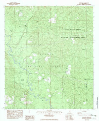
Black Creek winds through the heart of this landscape, carving a path through the De Soto National Forest and the Leaf River State Wildlife Management Area. The map reveals a sparsely settled region defined by family landholdings and small rural gathering points, such as Barbara and the Batt Place. For genealogists, the survey identifies several family burial grounds, including Thomas Cem, Cochran Cem, and Miles Cem, often situated near small watercourses like McLeod Branch or Hickory Creek. The presence of Fairley Bridge Landing suggests a historic reliance on river access for transportation and commerce in this corner of Perry and Stone Counties. Remote worship centers like St Luke Ch and Mars Hill Ch serve as focal points for the scattered communities, while oxbow features like Horseshoe Lake and Doctor Lake highlight the changing course of the local waterways over time.
Find a feature on this map
36 named features on this map. Tap any name to fly to it.
Don’t see what you’re looking for? This feature index may not catch every label — zoom into the map to look around manually.
Map Details
Editions of this 1982 Barbara Map
This is the sole edition of this map. No revisions or reprints were ever made.
Other maps of this area

1947 · Beaumont
USGS Topo · 1:62,500

1947 · Wiggins
USGS Topo · 1:62,500

1947 · New Augusta
USGS Topo · 1:62,500

1947 · Benndale
USGS Topo · 1:62,500

1949 · Wiggins
USGS Topo · 1:62,500

1949 · Beaumont
USGS Topo · 1:62,500

1949 · New Augusta
USGS Topo · 1:62,500

1949 · Benndale
USGS Topo · 1:62,500

1953 · Hattiesburg
USGS Topo · 1:250,000

1953 · Mobile
USGS Topo · 1:250,000