1940s Maps of Atchison County, Missouri
Explore 9 historic maps of Atchison County from the 1940s. These maps offer a rare glimpse into what life looked like during the 1940s — showing old roads, neighborhoods, homes, and landmarks that have changed or disappeared over time.
Whether you're researching your family's past, planning a metal detecting trip, or studying how Atchison County's landscape evolved across the 1940s, these high-resolution maps are a powerful tool for exploring the history of this region.
- Focus on a specific era: All maps on this page are from the 1940s, giving you a focused view of this time period.
- See what’s changed: Compare century-old streets, trails, and buildings to today's modern landscape using overlays and satellite layers.
- Research with precision: Use these maps for genealogy, historical research, land use analysis, or educational projects.
- View, download, or print: Maps are fully viewable online in high resolution, and can be downloaded or printed for your own records.
Start exploring Atchison County's history through authentic maps from the 1940s. This is your window into the past.
Atchison County, MO maps
(9)- 1940 Map of Tarkio
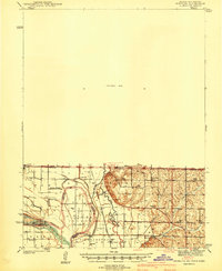
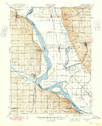
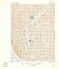 1940 Tarkio1940 Print · USGSAtchison County at the end of the Depression was a landscape of river-bottom farms and rural school districts. Genealogists can locate family-named landmarks and country parishes like English Grove Ch, Tarkio College, and Prairie Hill Cem.
 - 1940 Map of Farragut
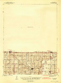
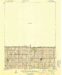 1940 Farragut1940 Print · USGSThe Iowa-Missouri state line serves as the anchor for this 1939 survey of Atchison, Fremont, and Page counties. Genealogists and local historians can trace the positions of vanished schoolhouses like Yale Sch and Emporia Sch, or locate family sites near Farmers City and Westboro.
 - 1940 Map of Coin, 1954 Print
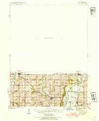 1940 Coin1954 Print · USGSThe borderlands of Iowa and Missouri come to life in this mid-century survey, showcasing the tight-knit farming communities across Page and Nodaway counties. Researchers can locate vanished rural landmarks like North Grove Sch and Six Corners Cem along the Wabash rail line.2 unique versions available
 - 1941 Map of Tarkio
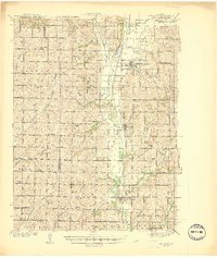
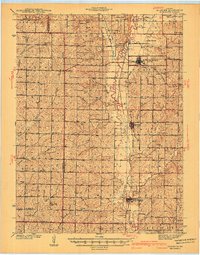
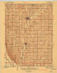 1941 Tarkio1941 Print · USGSNorthwest Missouri thrived as a region of productive townships and rail-connected towns just before the war. Researchers can locate dozens of country schoolhouses like Irish Grove Sch and family landmarks such as the English Grove Ch or Prairie Hill Cem.2 unique versions available
 - 1941 Map of Hamburg
 1941 Hamburg1941 Print · USGSThe Missouri-Iowa borderlands come alive in this pre-war survey of the river's winding oxbows and rural townships. Genealogists can trace family roots through a dense network of country schools and churches, from Mayflower Sch to the Stoner Cem.2 unique versions available
 - 1941 Map of Skidmore
 1941 Skidmore1941 Print · USGSNodaway County agriculture and transit thrive during the late thirties and early forties as major rail lines intersect. Genealogists can locate dozens of rural landmarks, including St Oswald Ch, Burlington Junction, and the Little Brick Sch.
 - 1942 Map of Skidmore
 1942 Skidmore1942 Print · USGSNodaway County is captured here in the early 1940s, showing a landscape defined by the Nodaway River and the Chicago Burlington and Quincy railroad. Researchers can trace dozens of country school sites like Little Brick Sch and Eudora Sch, or find family landmarks such as St Oswald Ch and London Cem.2 unique versions available
 - 1943 Map of Coin
 1943 Coin1943 Print · USGSThe rural borderlands of Iowa and Missouri were still defined by a dense network of country schools and rail lines in the early 1940s. Researchers can trace the exact locations of vanished rural anchors like White Chapel, Six Corners, and the High Prairie Cemetery.2 unique versions available
 - 1949 Map of Nemaha
 1949 Nemaha1949 Print · USGSThe Missouri River lowlands come alive in this post-war survey of the Nebraska-Missouri border. Genealogists can trace family roots through dozens of named country schools and small rail stops like McCandless Siding and the settlement of St Deroin.
End of results
Showing maps 1-9 of 9
Top cities of Atchison County
- Tarkio historical maps
- Rock Port historical maps
- Fairfax historical maps
- Westboro historical maps
- Watson historical maps
Frequently asked questions
- What are the different types of historical maps available for Atchison County?
- What is the oldest map of Atchison County?
- Where can I purchase historical maps of Atchison County for my home or office?
- Where can I download high-res historical maps of Atchison County?
- Are there historical topographic maps available for Atchison County?
- Is there historical aerial imagery available for Atchison County?
- Where are historical maps of Atchison County sourced from?