1980s Maps of Atchison County, Missouri
Explore 13 historic maps of Atchison County from the 1980s. These maps offer a rare glimpse into what life looked like during the 1980s — showing old roads, neighborhoods, homes, and landmarks that have changed or disappeared over time.
Whether you're researching your family's past, planning a metal detecting trip, or studying how Atchison County's landscape evolved across the 1980s, these high-resolution maps are a powerful tool for exploring the history of this region.
- Focus on a specific era: All maps on this page are from the 1980s, giving you a focused view of this time period.
- See what’s changed: Compare century-old streets, trails, and buildings to today's modern landscape using overlays and satellite layers.
- Research with precision: Use these maps for genealogy, historical research, land use analysis, or educational projects.
- View, download, or print: Maps are fully viewable online in high resolution, and can be downloaded or printed for your own records.
Start exploring Atchison County's history through authentic maps from the 1980s. This is your window into the past.
Atchison County, MO maps
(13)- 1981 Map of McElroy Creek
 1981 McElroy Creek1981 Print · USGSAcross the Iowa and Missouri border in the early eighties, this survey captures a landscape of family farms and rural parishes. Genealogists can locate family-named landmarks like Stoner Cem, Mt Olive Ch, and the waters of McElroy Creek.
 - 1981 Map of Blanchard
 1981 Blanchard1981 Print · USGSThe Iowa-Missouri borderlands appear in the early eighties as a landscape of rail-connected towns and quiet creek valleys. Genealogists can trace family footprints across Blanchard and College Springs or at rural sites like High Prairie Cem.
 - 1981 Map of Farmers City
 1981 Farmers City1981 Print · USGSThe Missouri-Iowa border region comes into focus during the early eighties, showing a landscape of small townships and family farms. Researchers can trace the rural communities of Farmers City and locate local landmarks like Grange Hall Cem and St Pauls Ch.
 - 1981 Map of Westboro
 1981 Westboro1981 Print · USGSThe Iowa-Missouri borderlands are captured here in the early eighties, showcasing a rural landscape defined by the Tarkio River watershed. Researchers can trace family sites at Union Grove Cem or follow the path of the Old Railroad Grade near Northboro.
 - 1981 Map of Tarkio West, 1982 Print
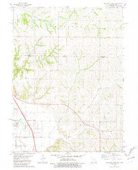
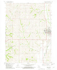 1981 Tarkio West1982 Print · USGSThe Atchison County prairie in the early eighties is captured here, centered on the campus and rail lines of the local hub. Researchers can locate Tarkio College, the Home Cemetery, and the Burlington Northern corridor as they appeared decades ago.
 - 1981 Map of Tarkio SE, 1982 Print
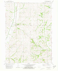
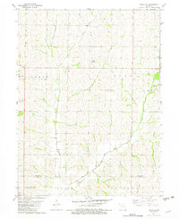 1981 Tarkio SE1982 Print · USGSNorthwest Missouri is captured here in the late seventies, showing the rolling creek valleys along the Atchison Co Holt Co border. Genealogists can trace family names and local landmarks like Sharps Grove Ch, Walkup Cem, and Tharp Cem.
 - 1981 Map of Dotham, 1982 Print
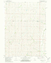
 1981 Dotham1982 Print · USGSAtchison and Nodaway counties in the late 1970s show a landscape shaped by agricultural tradition and numerous winding creek branches. Genealogists can locate family landmarks such as St Oswald Ch, Burr Oak Ch, and the community of Dotham.
 - 1981 Map of Rock Port, 1982 Print
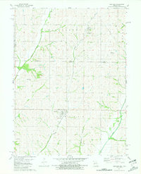
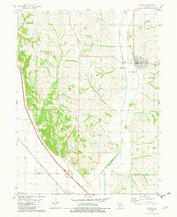
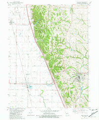 1981 Rock Port1982 Print · USGSAtchison County in the early eighties shows the Missouri River bluffs and the bustling county seat at Rock Port. Local historians can trace family roots at Addington Cem or Green Hill Cem and follow the old Burlington Northern rail line.
 - 1981 Map of Fairfax, 1982 Print
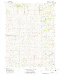
 1981 Fairfax1982 Print · USGSAgricultural life in northwest Missouri during the early eighties centered on the Tarkio River and the rails. Genealogists can locate family landmarks like English Grove Ch, Mount Hope Cem, and the old settlement of Milton.
 - 1981 Map of Skidmore NW, 1982 Print
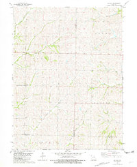
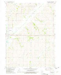
 1981 Skidmore NW1982 Print · USGSNorthwestern Missouri was a landscape of deep-cut creek beds and quiet townships in the early 1980s. Researchers can trace land ties across the Atchison Co Nodaway Co line or locate the London Cem and the waters of Headrick Branch.
 - 1981 Map of Tarkio East, 1982 Print
 1981 Tarkio East1982 Print · USGSAtchison County at the start of the 1980s showcases a rural landscape defined by the winding Tarkio River and its rail connections. Researchers can trace family history at Center Grove Cem or locate the local Oil Field and Community Hall.
 - 1985 Map of Nebraska City
 1985 Nebraska City1985 Print · USGSThe Missouri River borderlands of Nebraska, Iowa, and Missouri come into focus in the mid-1980s, showcasing a landscape of river navigation and rail-fed agriculture. Researchers can trace the heritage of Nebraska City, follow the Burlington Northern tracks, or explore river landmarks like Jones Point and McKissick Island.
 - 1986 Map of Falls City
 1986 Falls City1986 Print · USGSThe Missouri River borderlands of Nebraska and Missouri were a landscape of established colleges and river-bound railroads in the mid-1980s. Researchers can locate long-standing landmarks like Peru State College, the Iowa Indian Reservation, and St Johns Cem.2 unique versions available
End of results
Showing maps 1-13 of 13
Top cities of Atchison County
- Tarkio historical maps
- Rock Port historical maps
- Fairfax historical maps
- Westboro historical maps
- Watson historical maps
Frequently asked questions
- What are the different types of historical maps available for Atchison County?
- What is the oldest map of Atchison County?
- Where can I purchase historical maps of Atchison County for my home or office?
- Where can I download high-res historical maps of Atchison County?
- Are there historical topographic maps available for Atchison County?
- Is there historical aerial imagery available for Atchison County?
- Where are historical maps of Atchison County sourced from?