1980s Maps of Butler County, Missouri
Explore 11 historic maps of Butler County from the 1980s. These maps offer a rare glimpse into what life looked like during the 1980s — showing old roads, neighborhoods, homes, and landmarks that have changed or disappeared over time.
Whether you're researching your family's past, planning a metal detecting trip, or studying how Butler County's landscape evolved across the 1980s, these high-resolution maps are a powerful tool for exploring the history of this region.
- Focus on a specific era: All maps on this page are from the 1980s, giving you a focused view of this time period.
- See what’s changed: Compare century-old streets, trails, and buildings to today's modern landscape using overlays and satellite layers.
- Research with precision: Use these maps for genealogy, historical research, land use analysis, or educational projects.
- View, download, or print: Maps are fully viewable online in high resolution, and can be downloaded or printed for your own records.
Start exploring Butler County's history through authentic maps from the 1980s. This is your window into the past.
Butler County, MO maps
(11)- 1980 Map of Stringtown
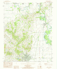
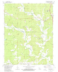 1980 Stringtown1980 Print · USGSButler County in the late 1970s is shown here as a landscape of timbered national forest and quiet river valleys. Genealogists and local historians can locate rural landmarks like Sparkman Cem, Kerns Chapel, and the small settlement of Stringtown.
 - 1980 Map of Hogan Hollow
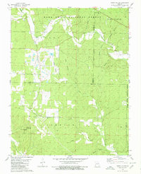 1980 Hogan Hollow1980 Print · USGSThe Ozark backcountry of the late seventies is centered on the settlement of Budapest and the timbered ridges of the Mark Twain National Forest. Genealogists can locate family burial sites at Scott Cem and Collins Cem or trace old tracks leading to the Grandin Lookout Tower.2 unique versions available
 - 1980 Map of Ellsinore
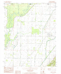
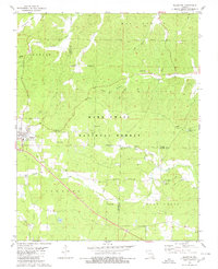 1980 Ellsinore1980 Print · USGSIn the southeastern Ozarks during the late 1970s, this area centers on the small rail town of Ellsinore and the surrounding timbered hollows. Genealogists can trace several family burial sites including Hill Top Cem and Kearney Cem near the headwaters of Cane Creek.
 - 1980 Map of Williamsville
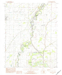
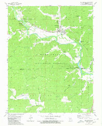 1980 Williamsville1980 Print · USGSThe Black River valley in the early eighties shows a landscape of deep Ozark forests and rail-fed settlements. You can trace old transit routes like the Old Military Road and local heritage at Holladay Cem and Keeners.
 - 1983 Map of Poplar Bluff
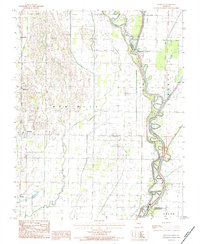
 1983 Poplar Bluff1983 Print · USGSSoutheast Missouri in the early 1980s reveals a landscape defined by the Ozark foothills and the complex drainage systems of the Bootheel. Researchers can trace the rail corridors of the Missouri Pacific RR through Poplar Bluff or locate rural sites like Wilhelmina Church and Lone Hill Lookout.
 - 1983 Map of Glennonville, 1984 Print
 1983 Glennonville1984 Print · USGSDunklin County agricultural and river life are preserved here in the early eighties, showcasing a landscape of drainage canals and small settlements. Researchers can trace the meandering St Francis River and locate historic community centers like Glennonville, Wilhelmina, and Qulin.
 - 1984 Map of Broseley
 1984 Broseley1984 Print · USGSSoutheast Missouri in the early eighties shows a landscape shaped by the St Francis River and extensive drainage projects. Genealogists and local historians can trace family locations near Broseley, Nyssa, and the high ground of Ash Hill.
 - 1984 Map of Mc Dougal
 1984 Mc Dougal1984 Print · USGSThe Missouri-Arkansas border comes into focus in the mid-1980s as it follows the winding path of the Black River. Researchers can trace old family roots and rural homesteads through settlements like McDougal, Hickoria, and the rising elevations of Crowleys Ridge.
 - 1984 Map of Pollard
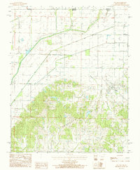 1984 Pollard1984 Print · USGSSettled along the edge of the ridge in the early 1980s, this area of Clay County showcases the intersection of timbered hills and engineered valley floors. Researchers can trace the drainage of the plains via the Little Cache River Ditch and locate the community of Pollard.
 - 1984 Map of Piggott
 1984 Piggott1984 Print · USGSClay County, Arkansas, was a landscape of river-bend borders and rail lines in the early 1980s. Genealogists and historians can trace the paths of the St Louis Southwestern railroad and locate old river features like Bass Island and Chalk Bluff.
 - 1984 Map of Paragould
 1984 Paragould1984 Print · USGSNortheast Arkansas and the Missouri Bootheel appear here in the mid-1980s as a landscape of ridge-top towns and engineered delta drainage. Genealogists and historians can locate rural landmarks like Oak Grove Church, trace the St Louis San Francisco RR, or explore the limits of Crowleys Ridge State Park.2 unique versions available
End of results
Showing maps 1-11 of 11
Top cities of Butler County
Frequently asked questions
- What are the different types of historical maps available for Butler County?
- What is the oldest map of Butler County?
- Where can I purchase historical maps of Butler County for my home or office?
- Where can I download high-res historical maps of Butler County?
- Are there historical topographic maps available for Butler County?
- Is there historical aerial imagery available for Butler County?
- Where are historical maps of Butler County sourced from?