1950s Maps of Butler County, Missouri
Explore 5 historic maps of Butler County from the 1950s. These maps offer a rare glimpse into what life looked like during the 1950s — showing old roads, neighborhoods, homes, and landmarks that have changed or disappeared over time.
Whether you're researching your family's past, planning a metal detecting trip, or studying how Butler County's landscape evolved across the 1950s, these high-resolution maps are a powerful tool for exploring the history of this region.
- Focus on a specific era: All maps on this page are from the 1950s, giving you a focused view of this time period.
- See what’s changed: Compare century-old streets, trails, and buildings to today's modern landscape using overlays and satellite layers.
- Research with precision: Use these maps for genealogy, historical research, land use analysis, or educational projects.
- View, download, or print: Maps are fully viewable online in high resolution, and can be downloaded or printed for your own records.
Start exploring Butler County's history through authentic maps from the 1950s. This is your window into the past.
Butler County, MO maps
(5)- 1956 Map of Valley Ridge
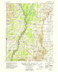 1956 Valley Ridge1956 Print · USGSDunklin and Butler counties in the mid-fifties show a landscape shaped by river transport and extensive drainage projects. Genealogists can locate many rural social hubs like Depoyster Ch & Sch, Higginbothams Ferry, and the St Louis Southwestern Railroad.
 - 1956 Map of Piggott
 1956 Piggott1956 Print · USGSThe Arkansas-Missouri borderlands in the mid-fifties were defined by the shifting loops of the St Francis River and the arrival of modern flood control. Researchers can locate vanished rural landmarks like Holly Island Community, Wrights Chapel, and the Meander Line of the old river channel.2 unique versions available
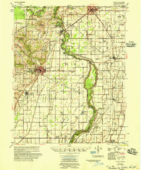
 - 1957 Map of Poplar Bluff, 1968 Print
 1957 Poplar Bluff1968 Print · USGSThe Missouri-Arkansas border region is captured here as the timber and rail industries shaped the Ozark foothills. Genealogists and historians can trace the Missouri Pacific Railroad through river towns like Pocahontas, Greenville, and Van Buren.3 unique versions available
 - 1958 Map of Rector, 1962 Print
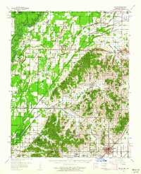 1958 Rector1962 Print · USGSClay County at the edge of the Missouri Bootheel was a landscape of ridge-top settlements and engineered bottomlands in the late fifties. Genealogists can trace family footprints across dozens of local landmarks like Knob Sch, Boydsville, and the Crockett Cem.2 unique versions available
 - 1959 Map of Poplar Bluff
 1959 Poplar Bluff1959 Print · USGSThe Missouri Ozarks and Arkansas borderlands meet in this late 1950s study of the region's diverse terrain and rail-fed towns. Researchers can trace the path of the Missouri Pacific Railroad through Poplar Bluff or locate smaller settlements like Birch Tree and Myrtle.
End of results
Showing maps 1-5 of 5
Top cities of Butler County
Frequently asked questions
- What are the different types of historical maps available for Butler County?
- What is the oldest map of Butler County?
- Where can I purchase historical maps of Butler County for my home or office?
- Where can I download high-res historical maps of Butler County?
- Are there historical topographic maps available for Butler County?
- Is there historical aerial imagery available for Butler County?
- Where are historical maps of Butler County sourced from?