1900s (20th Century) Maps of Butler County, Missouri
Explore 51 historic maps of Butler County from the 1900s (20th Century). These maps offer a rare glimpse into what life looked like during the 1900s — showing old roads, neighborhoods, homes, and landmarks that have changed or disappeared over time.
Whether you're researching your family's past, planning a metal detecting trip, or studying how Butler County's landscape evolved across the 1900s, these high-resolution maps are a powerful tool for exploring the history of this region.
- Focus on a specific era: All maps on this page are from the 1900s, giving you a focused view of this time period.
- See what’s changed: Compare century-old streets, trails, and buildings to today's modern landscape using overlays and satellite layers.
- Research with precision: Use these maps for genealogy, historical research, land use analysis, or educational projects.
- View, download, or print: Maps are fully viewable online in high resolution, and can be downloaded or printed for your own records.
Start exploring Butler County's history through authentic maps from the 1900s. This is your window into the past.
Butler County, MO maps
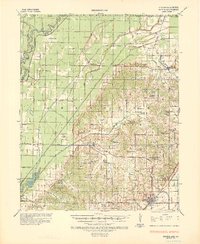
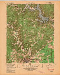
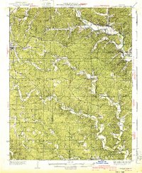
(51)- 1934 Map of Williamsville
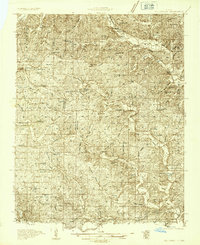 1934 Williamsville1934 Print · USGSThe Ozark foothills near the Wayne and Butler county line come into focus during the mid-1930s, showing a landscape of timbered hollows and nascent highways. Researchers can locate vanished rural landmarks like the Lone Star School, Kearney Cem, and the specialized Keener Cave Resort.4 unique versions available
 - 1934 Map of Puxico
 1934 Puxico1934 Print · USGSThe Missouri Bootheel comes into focus during the 1930s as drainage projects and rail lines reshape the swampy lowlands. Genealogists can locate dozens of country schools like Wilkerson Sch and Zoll Sch, or trace the tracks of the St Louis San Francisco through Puxico.2 unique versions available
 - 1935 Map of Poplar Bluff
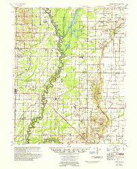
 1935 Poplar Bluff1935 Print · USGSSoutheast Missouri’s river-and-rail landscape is captured here in the mid-thirties as the timber and agricultural economy flourished. Trace family homesteads near Taskee Sta, identify old rural schools like Snyder Sch, and follow the original routes of the Missouri Pacific.3 unique versions available
 - 1935 Map of Acorn, 1936 Print
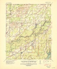
 1935 Acorn1936 Print · USGSRipley and Butler counties are captured in the mid-1930s just as drainage projects were reshaping the river bottomlands. Researchers can trace vanished rail stops and numerous combined community hubs like Spring Hill Sch & Cem, Venerable Sch, and Torch.
 - 1935 Map of Rector, 1936 Print
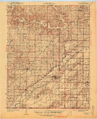
 1935 Rector1936 Print · USGSClay County at the height of the 1930s drainage era shows a landscape being reshaped by massive flood control projects and rail expansion. Genealogists can locate family landmarks like Boydsville, the Trovillon Cem, and rural schoolhouses such as Turtle Knob Sch.3 unique versions available
 - 1935 Map of Knobel, 1938 Print
 1935 Knobel1938 Print · USGSDuring the mid-1930s, the Arkansas-Missouri borderlands were defined by the rail lines and river bends of the Black River valley. Researchers can trace family roots through Peach Orchard, Hopewell Ch, and cemeteries like Al McNaner Cem.
 - 1935 Map of Harviell, 1943 Print
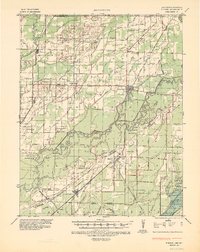
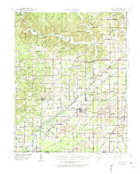
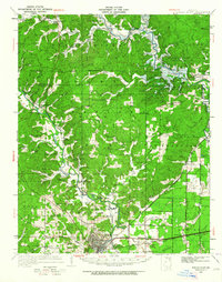
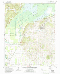
 1935 Harviell1943 Print · USGSButler County in the mid-1930s was a landscape of river bends and scattered rural schoolhouses along the St Louis San Francisco Railroad. Genealogists can trace family roots at Black Creek Ch & Cem or locate vanished local schools like Gillis Bluff Sch and Havam Sch.2 unique versions available
 - 1939 Map of Puxico, 1942 Print
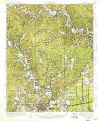
 1939 Puxico1942 Print · USGSSoutheast Missouri's bootheel region comes to life in the late 1930s, showing a landscape defined by extensive drainage projects and burgeoning rail towns. Trace the locations of rural schoolhouses like Edmundson Sch and lost junctions along the St Louis - San Francisco Ry.
 - 1939 Map of Poplar Bluff, 1949 Print
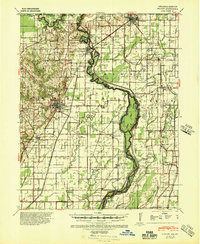
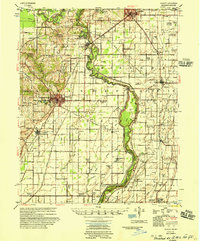
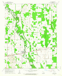
 1939 Poplar Bluff1949 Print · USGSSoutheast Missouri’s river-and-rail hub is captured here during the transformative period when the Black River was being dammed. Genealogists can trace family names across a landscape of schools and churches like Baskey Sch, Butler Cem, and Taskee Sta.
 - 1940 Map of Williamsville
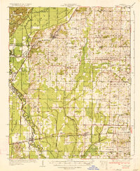
 1940 Williamsville1940 Print · USGSThe eastern Ozarks at the start of the 1940s reveal a bustling rail-and-river economy centered on the junction of the Missouri Pacific and St Louis - San Francisco. Researchers can trace the unique immigrant history of Budapest or locate vanished landmarks like the Fire Tower CCC Camp and Barrett Mine.2 unique versions available
 - 1940 Map of Naylor
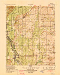
 1940 Naylor1940 Print · USGSRipley and Butler counties are captured here just before the mid-century, showing a landscape defined by the Little Black River and a dense rail network. Genealogists can trace family roots through dozens of local sites like Sixteen to One Sch and the Military Cem.
 - 1940 Map of Valley Ridge, 1943 Print
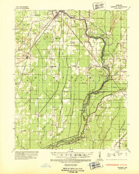
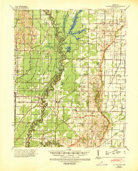 1940 Valley Ridge1943 Print · USGSDunklin and Butler counties come to life in the early 1940s, where the St Francis River winds through a landscape of new drainage ditches and high ridges. Researchers can locate family landmarks like Stephens Cem or trace old river crossings at Higginbothams Ferry.
 - 1940 Map of Piggott, 1945 Print
 1940 Piggott1945 Print · USGSNortheast Arkansas and the Missouri Bootheel meet along the winding St Francis River in the decade before the post-war era. Genealogists and local historians can locate numerous rural landmarks including Gravel Hill Ch & Cem, Pine City, and the St Louis Southwestern RR line.
 - 1941 Map of Knobel, 1946 Print
 1941 Knobel1946 Print · USGSClay County at the onset of the 1940s is defined by the winding Black River and the critical rail junctions that sustained its small towns. Researchers can trace family roots through numerous rural landmarks like Masterson Cem, Brazil Sch & Ch, and the river crossing at Bennetts Ferry Bridge.2 unique versions available
 - 1944 Map of Naylor
 1944 Naylor1944 Print · USGSThe Missouri-Arkansas border region in the early 1940s reveals a landscape shaped by the St Louis San Francisco railroad and the historic Military Road. Researchers can trace old family-named sites like Cochran Cem, Sewell Sch, and the riverside settlement of Naylor.2 unique versions available
 - 1949 Map of Poplar Bluff, 1964 Print
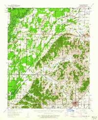
 1949 Poplar Bluff1964 Print · USGSThe area surrounding Poplar Bluff is shown during a period of transition as the Ozark hills meet the engineered drainage canals of the lowlands. Researchers can trace the St Louis San Francisco railroad through rural stops like Chaonia and Taskee Sta.
 - 1956 Map of Valley Ridge
 1956 Valley Ridge1956 Print · USGSDunklin and Butler counties in the mid-fifties show a landscape shaped by river transport and extensive drainage projects. Genealogists can locate many rural social hubs like Depoyster Ch & Sch, Higginbothams Ferry, and the St Louis Southwestern Railroad.
 - 1956 Map of Piggott
 1956 Piggott1956 Print · USGSThe Arkansas-Missouri borderlands in the mid-fifties were defined by the shifting loops of the St Francis River and the arrival of modern flood control. Researchers can locate vanished rural landmarks like Holly Island Community, Wrights Chapel, and the Meander Line of the old river channel.2 unique versions available
 - 1957 Map of Poplar Bluff, 1968 Print
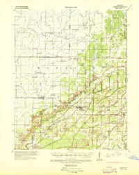
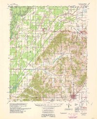
 1957 Poplar Bluff1968 Print · USGSThe Missouri-Arkansas border region is captured here as the timber and rail industries shaped the Ozark foothills. Genealogists and historians can trace the Missouri Pacific Railroad through river towns like Pocahontas, Greenville, and Van Buren.3 unique versions available
 - 1958 Map of Rector, 1962 Print
 1958 Rector1962 Print · USGSClay County at the edge of the Missouri Bootheel was a landscape of ridge-top settlements and engineered bottomlands in the late fifties. Genealogists can trace family footprints across dozens of local landmarks like Knob Sch, Boydsville, and the Crockett Cem.2 unique versions available
 - 1959 Map of Poplar Bluff
 1959 Poplar Bluff1959 Print · USGSThe Missouri Ozarks and Arkansas borderlands meet in this late 1950s study of the region's diverse terrain and rail-fed towns. Researchers can trace the path of the Missouri Pacific Railroad through Poplar Bluff or locate smaller settlements like Birch Tree and Myrtle.
 - 1960 Map of Rector
 1960 Rector1960 Print · USGSClay County at the end of the fifties reveals a landscape shaped by the rise of Crowleys Ridge and an intricate network of drainage ditches. Local historians can trace the foundations of Rector and Boydsville or locate rural landmarks like the Knob Sch and Purcell Mill.
 - 1960 Map of Poplar Bluff
 1960 Poplar Bluff1960 Print · USGSSoutheast Missouri and Northeast Arkansas are captured here during the post-war era, showing the transition from the Ozark highlands to the Delta. Genealogists and historians can trace rail corridors like the St. Louis Southwestern RR and remote settlements such as Birch Tree and Warm Springs.
 - 1962 Map of Fisk, 1963 Print
 1962 Fisk1963 Print · USGSFisk and the surrounding river bottomlands are captured here in the early sixties, as the local economy relied on the railroad and a vast network of drainage canals. Researchers can trace the Missouri Pacific rail corridor through Ash Hill and Ives, or locate rural landmarks like Owens Cem and Hobbe Chapel.2 unique versions available
 - 1962 Map of Puxico, 1963 Print
 1962 Puxico1963 Print · USGSThe southeast Missouri lowlands and the edge of the Ozarks are captured here during the early sixties, showing a landscape defined by drainage engineering and wildlife conservation. Genealogists and historians can trace family locations near Puxico, Asherville, and rural gathering places like Egypt Church or Gravel Hill Cemetery.3 unique versions available
Showing maps 1-25 of 51
Top cities of Butler County
Frequently asked questions
- What are the different types of historical maps available for Butler County?
- What is the oldest map of Butler County?
- Where can I purchase historical maps of Butler County for my home or office?
- Where can I download high-res historical maps of Butler County?
- Are there historical topographic maps available for Butler County?
- Is there historical aerial imagery available for Butler County?
- Where are historical maps of Butler County sourced from?