1940s Maps of Camden County, Missouri
Explore 2 historic maps of Camden County from the 1940s. These maps offer a rare glimpse into what life looked like during the 1940s — showing old roads, neighborhoods, homes, and landmarks that have changed or disappeared over time.
Whether you're researching your family's past, planning a metal detecting trip, or studying how Camden County's landscape evolved across the 1940s, these high-resolution maps are a powerful tool for exploring the history of this region.
- Focus on a specific era: All maps on this page are from the 1940s, giving you a focused view of this time period.
- See what’s changed: Compare century-old streets, trails, and buildings to today's modern landscape using overlays and satellite layers.
- Research with precision: Use these maps for genealogy, historical research, land use analysis, or educational projects.
- View, download, or print: Maps are fully viewable online in high resolution, and can be downloaded or printed for your own records.
Start exploring Camden County's history through authentic maps from the 1940s. This is your window into the past.
Camden County, MO maps
(2)- 1943 Map of Richland
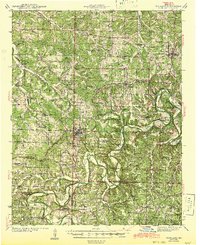 1943 Richland1943 Print · USGSThe Missouri Ozarks during the early 1940s are documented here, showing the rural communities of Pulaski and Camden counties connected by the rail lines. Genealogists can locate family landmarks like Manes Cem, Buzzard Roost Sch, and Wair Chapel.
 - 1947 Map of Jefferson City, 1949 Print
 1947 Jefferson City1949 Print · USGSCentral Missouri and the northern Ozarks come into focus in this late 1940s survey of the river-and-rail landscape. Genealogists and historians can trace the growth of Jefferson City and Sedalia or locate family roots near Bagnell Dam and the Lake of the Ozarks.
End of results
Showing maps 1-2 of 2
Top cities of Camden County
- Osage Beach historical maps
- Camdenton historical maps
- Four Seasons historical maps
- Sunrise Beach historical maps
- Linn Creek historical maps
- Macks Creek historical maps
See more
Frequently asked questions
- What are the different types of historical maps available for Camden County?
- What is the oldest map of Camden County?
- Where can I purchase historical maps of Camden County for my home or office?
- Where can I download high-res historical maps of Camden County?
- Are there historical topographic maps available for Camden County?
- Is there historical aerial imagery available for Camden County?
- Where are historical maps of Camden County sourced from?