1980s Maps of Camden County, Missouri
Explore 17 historic maps of Camden County from the 1980s. These maps offer a rare glimpse into what life looked like during the 1980s — showing old roads, neighborhoods, homes, and landmarks that have changed or disappeared over time.
Whether you're researching your family's past, planning a metal detecting trip, or studying how Camden County's landscape evolved across the 1980s, these high-resolution maps are a powerful tool for exploring the history of this region.
- Focus on a specific era: All maps on this page are from the 1980s, giving you a focused view of this time period.
- See what’s changed: Compare century-old streets, trails, and buildings to today's modern landscape using overlays and satellite layers.
- Research with precision: Use these maps for genealogy, historical research, land use analysis, or educational projects.
- View, download, or print: Maps are fully viewable online in high resolution, and can be downloaded or printed for your own records.
Start exploring Camden County's history through authentic maps from the 1980s. This is your window into the past.
Camden County, MO maps
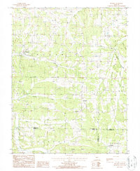
(17)- 1982 Map of Macks Creek, 1983 Print
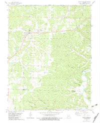 1982 Macks Creek1983 Print · USGSThe Missouri Ozarks are captured here in the early 1980s as the rugged terrain of the Camden and Dallas county line remained deeply rural. Genealogists can trace local roots through the Wiley Gott Cem, Mission Ridge Ch, and the small community of Celt.
 - 1982 Map of Hahatonka, 1983 Print
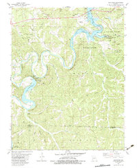 1982 Hahatonka1983 Print · USGSThe Lake of the Ozarks region in the early 1980s reveals a rugged landscape of river bluffs and hydroelectric development. Genealogists and hikers can locate the Ruins and Natural Bridge at Ha Ha Tonka State Park or trace family sites like Dickerson Cem.2 unique versions available
 - 1982 Map of Lebanon, 1983 Print
 1982 Lebanon1983 Print · USGSThe Missouri Ozarks are captured in the early eighties as Interstate 44 and the St Louis-San Francisco rail line link growing towns with the Fort Leonard Wood Military Reservation. Genealogists and historians can trace family-named sites like Flatwood Church and old post offices at Sleeper and Nebo.
 - 1983 Map of Sunrise Beach
 1983 Sunrise Beach1983 Print · USGSThe northern reaches of the Lake of the Ozarks are captured here in the early eighties, showcasing a landscape of winding coves and growing shoreline communities. Researchers can locate numerous family burial sites like Garber Memorial Cem or trace landmarks such as the Hurricane Deck Lookout Tower and Purvis.2 unique versions available
 - 1983 Map of Bagnell
 1983 Bagnell1983 Print · USGSThe Lake of the Ozarks and the Bagnell Dam era are captured here during the early eighties, showing the shift from rural hollows to a booming resort region. Genealogists can locate family burial sites like Flatwoods Cem and Henderson Cem, or trace the old paths near Indian Burial Cave.
 - 1983 Map of Toronto
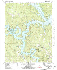
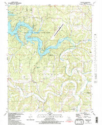 1983 Toronto1983 Print · USGSCamden County and the northern reaches of the Ozarks are captured here in the early eighties as lake recreation and aviation began to reshape the rural landscape. Researchers can locate family sites and landmarks like Ozark Caverns, Freedom Cem, and the old Swinging Bridge over Grandglaize Creek.2 unique versions available
 - 1983 Map of Lake Ozark
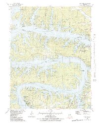 1983 Lake Ozark1983 Print · USGSThe Lake of the Ozarks shoreline is shown in intricate detail in the early eighties, highlighting the intersection of Miller, Morgan, and Camden counties. Genealogists and historians can trace family landmarks like Houston Cem, Millstone Ch, and the submerged history of Kinchlow Hol Cove.3 unique versions available
 - 1983 Map of Bollinger Creek
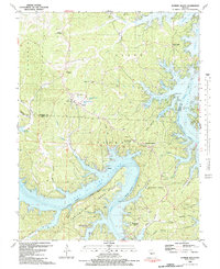
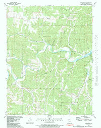
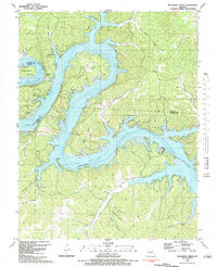 1983 Bollinger Creek1983 Print · USGSThe Lake of the Ozarks shoreline and the Osage River valley are shown here in the early eighties as the area developed into a recreational hub. Researchers can locate family burial grounds like Parish Cem and Woolery Cem or the remote Ivy Bend Landing Strip.
 - 1983 Map of Camdenton
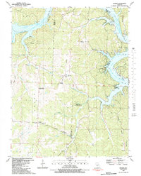
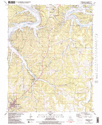 1983 Camdenton1983 Print · USGSCamden County was entering a new era of tourism and development in the early eighties as the lake transformed the Missouri hills. Researchers can trace the relocation of Old Linn Creek and locate several family burial grounds like Zion Cem and Hall Cem.2 unique versions available
 - 1983 Map of Green Bay Terrace
 1983 Green Bay Terrace1983 Print · USGSThe Niangua Arm of the Lake of the Ozarks reached deep into the Ozark hills by the early 1980s, shaping new recreational communities and shoreline landmarks. Genealogists and local historians can locate Farmer Cem, Montgomery Ch, and the rural settlement of Neongwah.2 unique versions available
 - 1983 Map of Knobby
 1983 Knobby1983 Print · USGSThe northern Ozarks landscape is captured here in the early 1980s, where the winding Lake of the Ozarks meets rugged Missouri ridges. Genealogists and hikers can trace old family landmarks like Dority Cemetery, Adkins Cave, and the small settlement of Knobby.
 - 1983 Map of Barnumton
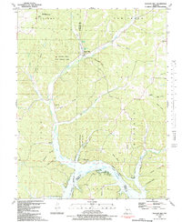
 1983 Barnumton1983 Print · USGSCamden County's river valleys and wooded hollows are captured here in the early eighties, showing the Niangua River as it meets Lake of the Ozarks. Genealogists can trace family footprints across numerous rural burial sites like Edwards Cemetery and historical landmarks such as Bannister Ford.
 - 1983 Map of Boylers Mill
 1983 Boylers Mill1983 Print · USGSThe northern reaches of the Lake of the Ozarks meet the Missouri Ozarks in the early 1980s, documenting a landscape of steep hollows and family cemeteries. Locate local landmarks like Boylers Mill, the Mt Hulda Lookout Tower, and Shiloh Cem.
 - 1983 Map of Harry S Truman Reservoir, 1984 Print
 1983 Harry S Truman Reservoir1984 Print · USGSBenton and Henry counties center on the vast Harry S Truman Reservoir in the early 1980s as the landscape adapted to its new shoreline. Genealogists and historians can trace old river crossings like Bledsoe Ferry, local landmarks like Mt Zion Ch, and unique settlements such as Tightwad.
 - 1983 Map of Lake Of The Ozarks, 1984 Print
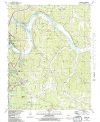
 1983 Lake Of The Ozarks1984 Print · USGSThe Lake of the Ozarks region in the early eighties shows a landscape of deep river bends and growing recreation. Genealogists can trace family names and small settlements from Versailles to Meta and locate old mining sites like Tiff Mine.
 - 1984 Map of Bolivar
 1984 Bolivar1984 Print · USGSWestern Missouri in the mid-eighties shows a landscape shaped by large-scale water management and rail commerce. Genealogists and historians can trace the development of towns like Bolivar and El Dorado Springs alongside the massive Stockton Lake.
 - 1987 Map of Brumley, 1988 Print
 1987 Brumley1988 Print · USGSThe Missouri Ozarks are captured here in the 1980s at the intersection of Miller, Camden, and Pulaski counties. Researchers can trace rural settlement patterns in communities like Brumley, Keethtown, and Samtown along the waters of Tavern Creek.
End of results
Showing maps 1-17 of 17
Top cities of Camden County
- Osage Beach historical maps
- Camdenton historical maps
- Four Seasons historical maps
- Sunrise Beach historical maps
- Linn Creek historical maps
- Macks Creek historical maps
See more
Frequently asked questions
- What are the different types of historical maps available for Camden County?
- What is the oldest map of Camden County?
- Where can I purchase historical maps of Camden County for my home or office?
- Where can I download high-res historical maps of Camden County?
- Are there historical topographic maps available for Camden County?
- Is there historical aerial imagery available for Camden County?
- Where are historical maps of Camden County sourced from?