1930s Maps of Carter County, Missouri
Explore 3 historic maps of Carter County from the 1930s. These maps offer a rare glimpse into what life looked like during the 1930s — showing old roads, neighborhoods, homes, and landmarks that have changed or disappeared over time.
Whether you're researching your family's past, planning a metal detecting trip, or studying how Carter County's landscape evolved across the 1930s, these high-resolution maps are a powerful tool for exploring the history of this region.
- Focus on a specific era: All maps on this page are from the 1930s, giving you a focused view of this time period.
- See what’s changed: Compare century-old streets, trails, and buildings to today's modern landscape using overlays and satellite layers.
- Research with precision: Use these maps for genealogy, historical research, land use analysis, or educational projects.
- View, download, or print: Maps are fully viewable online in high resolution, and can be downloaded or printed for your own records.
Start exploring Carter County's history through authentic maps from the 1930s. This is your window into the past.
Carter County, MO maps
(3)- 1932 Map of Piedmont, 1955 Print
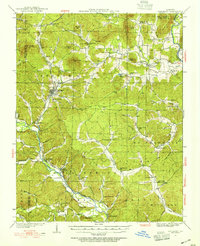 1932 Piedmont1955 Print · USGSThe Ozark foothills come to life in the early 1930s, showing a landscape defined by the Black Missouri River and the railroad. Genealogists can trace family roots through numerous rural landmarks like Hog Eye Sch, Dees Chapel, and the community of Patterson.2 unique versions available
 - 1934 Map of Williamsville
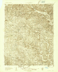 1934 Williamsville1934 Print · USGSThe Ozark foothills near the Wayne and Butler county line come into focus during the mid-1930s, showing a landscape of timbered hollows and nascent highways. Researchers can locate vanished rural landmarks like the Lone Star School, Kearney Cem, and the specialized Keener Cave Resort.4 unique versions available
 - 1935 Map of Piedmont
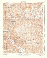 1935 Piedmont1935 Print · USGSWayne County is shown in the mid-1930s as a landscape of timbered ridges and river valleys centered on the rail hub of Piedmont. Genealogists can trace family landmarks like Watkins Store or locate rural centers like Gads Hill and Dees Chapel Sch.2 unique versions available
End of results
Showing maps 1-3 of 3
Top cities of Carter County
Frequently asked questions
- What are the different types of historical maps available for Carter County?
- What is the oldest map of Carter County?
- Where can I purchase historical maps of Carter County for my home or office?
- Where can I download high-res historical maps of Carter County?
- Are there historical topographic maps available for Carter County?
- Is there historical aerial imagery available for Carter County?
- Where are historical maps of Carter County sourced from?