1940s Maps of Carter County, Missouri
Explore 9 historic maps of Carter County from the 1940s. These maps offer a rare glimpse into what life looked like during the 1940s — showing old roads, neighborhoods, homes, and landmarks that have changed or disappeared over time.
Whether you're researching your family's past, planning a metal detecting trip, or studying how Carter County's landscape evolved across the 1940s, these high-resolution maps are a powerful tool for exploring the history of this region.
- Focus on a specific era: All maps on this page are from the 1940s, giving you a focused view of this time period.
- See what’s changed: Compare century-old streets, trails, and buildings to today's modern landscape using overlays and satellite layers.
- Research with precision: Use these maps for genealogy, historical research, land use analysis, or educational projects.
- View, download, or print: Maps are fully viewable online in high resolution, and can be downloaded or printed for your own records.
Start exploring Carter County's history through authentic maps from the 1940s. This is your window into the past.
Carter County, MO maps
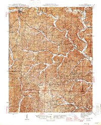
(9)- 1940 Map of Williamsville
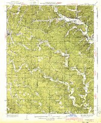 1940 Williamsville1940 Print · USGSThe eastern Ozarks at the start of the 1940s reveal a bustling rail-and-river economy centered on the junction of the Missouri Pacific and St Louis - San Francisco. Researchers can trace the unique immigrant history of Budapest or locate vanished landmarks like the Fire Tower CCC Camp and Barrett Mine.2 unique versions available
 - 1943 Map of Ellington, 1956 Print
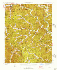 1943 Ellington1956 Print · USGSThe Reynolds County timberlands and river valleys are captured here in the 1940s as the local landscape faced significant change. Genealogists can trace family footprints through numerous rural landmarks like Pine Valley Cem, Garwood, and Carter Mill Sch.
 - 1944 Map of Van Buren, 1960 Print
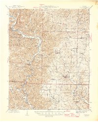
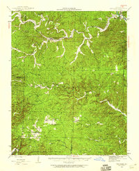 1944 Van Buren1960 Print · USGSThe Ozark hill country of Carter and Shannon counties appears here in the mid-1940s. Researchers can trace the St Louis San Francisco rail line or locate rural sites like Pleasant Site Cem, Chicopee, and the Bristoll Sch.2 unique versions available
 - 1944 Map of Grandin, 1962 Print
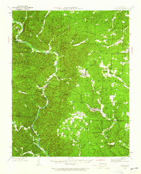 1944 Grandin1962 Print · USGSDeep in the Ozarks during the 1940s, this area shows a landscape of ridge-top schools and river-bottom homesteads. Genealogists can trace family sites like McDowell Place or search for roots near Shiloh Cem and the Old Iron Mines.
 - 1945 Map of Ellington
 1945 Ellington1945 Print · USGSThe Missouri Ozarks are captured here during the mid-forties, showing the deep-valley settlements of Reynolds and Carter counties. Genealogists can locate family landmarks such as Newton Cem, Doe Run Ch, and the Upper Doe Run Sch.2 unique versions available
 - 1946 Map of Grandin
 1946 Grandin1946 Print · USGSThe Ozark hills of Carter and Ripley Counties are captured here in the mid-1940s, highlighting the area's timber and mining heritage. Researchers can locate vanished landmarks like Crossroads Sch, trace the Old Iron Mines, or find family plots at Shiloh Cem.2 unique versions available
 - 1946 Map of Van Buren
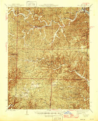 1946 Van Buren1946 Print · USGSThe Ozark foothills of Carter County are shown here in the 1940s, dominated by the winding Current River and the sprawling Clark National Forest. Genealogists and hikers can trace the footprints of rural communities at Wilderness, Bristol Church, and Rinnard School.2 unique versions available
 - 1949 Map of Rolla, 1950 Print
 1949 Rolla1950 Print · USGSThe Missouri Ozarks are captured here just after the war, showing a landscape of deep river valleys and emerging reservoir projects. Genealogists and historians can trace the mining towns of Bonne Terre and Potosi or follow the early route of U.S. Highway 66.
 - 1949 Map of Cardareva, 1957 Print
 1949 Cardareva1957 Print · USGSThe mid-century Ozark backcountry along the Current River is detailed here, showing a landscape of river-bend settlements and deep hollows. Researchers can trace rural life through numerous fords and one-room schoolhouses like Owls Bend School and Cardareva Ford.
End of results
Showing maps 1-9 of 9
Top cities of Carter County
Frequently asked questions
- What are the different types of historical maps available for Carter County?
- What is the oldest map of Carter County?
- Where can I purchase historical maps of Carter County for my home or office?
- Where can I download high-res historical maps of Carter County?
- Are there historical topographic maps available for Carter County?
- Is there historical aerial imagery available for Carter County?
- Where are historical maps of Carter County sourced from?