1950s Maps of Christian County, Missouri
Explore 12 historic maps of Christian County from the 1950s. These maps offer a rare glimpse into what life looked like during the 1950s — showing old roads, neighborhoods, homes, and landmarks that have changed or disappeared over time.
Whether you're researching your family's past, planning a metal detecting trip, or studying how Christian County's landscape evolved across the 1950s, these high-resolution maps are a powerful tool for exploring the history of this region.
- Focus on a specific era: All maps on this page are from the 1950s, giving you a focused view of this time period.
- See what’s changed: Compare century-old streets, trails, and buildings to today's modern landscape using overlays and satellite layers.
- Research with precision: Use these maps for genealogy, historical research, land use analysis, or educational projects.
- View, download, or print: Maps are fully viewable online in high resolution, and can be downloaded or printed for your own records.
Start exploring Christian County's history through authentic maps from the 1950s. This is your window into the past.
Christian County, MO maps
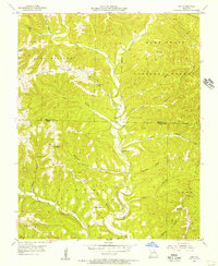
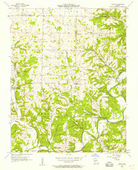
(12)- 1954 Map of Harrison
 1954 Harrison1954 Print · USGSThe Ozarks and Boston Mountains meet during a period of massive river engineering in the mid-fifties. Researchers can trace the early shorelines of Bull Shoals Lake and Table Rock Reservoir or locate inland towns like Berryville and Harrison.
 - 1954 Map of Springfield
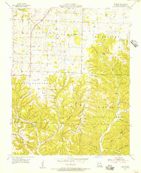
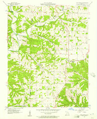
 1954 Springfield1954 Print · USGSThe Missouri Ozarks are captured here during the post-war era, showing the expansion of Springfield and the surrounding river valleys. Genealogists and historians can trace local landmarks like Mount Comfort Cemetery and the Fort Leonard Wood military grounds.6 unique versions available
 - 1955 Map of Garrison, 1956 Print
 1955 Garrison1956 Print · USGSThe border of Christian and Taney Counties is shown here in the mid-1950s, when remote ridges and deep hollows still defined local life. Researchers can find ancestral landmarks like Lone Star Ch, the Middleton Sch, and the winding banks of Swan Creek.3 unique versions available
 - 1955 Map of Selmore, 1956 Print
 1955 Selmore1956 Print · USGSChristian County's rural character is preserved here in the mid-fifties, showing the rugged intersection of farm life and the Mark Twain National Forest. Genealogists can locate family landmarks like Adams Cem, Cobb Cem, and the small settlement of Selmore.2 unique versions available
 - 1955 Map of Chadwick, 1956 Print
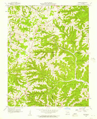
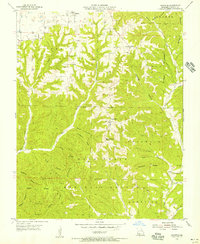 1955 Chadwick1956 Print · USGSChristian County's Ozark highlands are captured here in the mid-fifties, showing a landscape defined by deep hollows and isolated upland farms. Researchers can locate family landmarks like Gardner Cem, the Fairview Ch, and the legendary Bald Knobbers Cave.2 unique versions available
 - 1955 Map of Day, 1956 Print
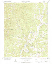
 1955 Day1956 Print · USGSThe Ozark hills along the Christian and Taney County line are shown here in the mid-fifties, dominated by the timbered ridges of the Mark Twain National Forest. Genealogists can trace rural family sites like Nash Cem and remote congregations including Oak Ridge Ch and Meadows Ch.4 unique versions available
 - 1955 Map of Hurley, 1957 Print
 1955 Hurley1957 Print · USGSStone and Christian Counties were characterized by small farming hamlets and river-valley crossings in the mid-fifties. Genealogists can trace family names at Wright Chapel Cem or locate old community centers like Possum Trot, Lanetown, and Union City.2 unique versions available
 - 1955 Map of Highlandville, 1957 Print
 1955 Highlandville1957 Print · USGSThe Missouri Ozarks are captured here in the mid-1950s, showing a landscape of upland ridges and deep-cut creek valleys. Genealogists can locate family burial sites like Mayberry Cem and Tory Cem or rural centers like Ponce de Leon.2 unique versions available
 - 1956 Map of Spokane, 1957 Print
 1956 Spokane1957 Print · USGSThe Ozark plateau in the mid-1950s reveals a network of ridge-top settlements and creek-bottom homesteads across Christian and Stone Counties. Local researchers can trace family landmarks like Schupbach Cem, the site of Old Spanish Cave, and the rural community of Abesville.2 unique versions available
 - 1958 Map of Springfield
 1958 Springfield1958 Print · USGSThe Missouri Ozarks are captured during the mid-century era of growth, centered on the bustling hub of Springfield. Genealogists and historians can trace family roots through numerous landmarks like Ebenezer Church, Stockton Cem, and the various county courthouses.
 - 1958 Map of Harrison, 1973 Print
 1958 Harrison1973 Print · USGSThe Ozark and Boston Mountains appear in this mid-century survey as the great White River impoundments were reshaping the region. Researchers can trace the rail lines of the St Louis-San Francisco Ry and locate early settlements like Berryville and Gainesville.
 - 1959 Map of Springfield
 1959 Springfield1959 Print · USGSThe Missouri Ozarks are captured here during a decade of postwar growth and increasing highway connectivity. Researchers can trace the legacy of the St Louis-San Francisco RR and locate early sites in Springfield, Lebanon, and Mountain Grove.
End of results
Showing maps 1-12 of 12
Top cities of Christian County
- Nixa historical maps
- Ozark historical maps
- Clever historical maps
- Sparta historical maps
- Billings historical maps
- Highlandville historical maps
See more
Frequently asked questions
- What are the different types of historical maps available for Christian County?
- What is the oldest map of Christian County?
- Where can I purchase historical maps of Christian County for my home or office?
- Where can I download high-res historical maps of Christian County?
- Are there historical topographic maps available for Christian County?
- Is there historical aerial imagery available for Christian County?
- Where are historical maps of Christian County sourced from?