1960s Maps of Christian County, Missouri
Explore 4 historic maps of Christian County from the 1960s. These maps offer a rare glimpse into what life looked like during the 1960s — showing old roads, neighborhoods, homes, and landmarks that have changed or disappeared over time.
Whether you're researching your family's past, planning a metal detecting trip, or studying how Christian County's landscape evolved across the 1960s, these high-resolution maps are a powerful tool for exploring the history of this region.
- Focus on a specific era: All maps on this page are from the 1960s, giving you a focused view of this time period.
- See what’s changed: Compare century-old streets, trails, and buildings to today's modern landscape using overlays and satellite layers.
- Research with precision: Use these maps for genealogy, historical research, land use analysis, or educational projects.
- View, download, or print: Maps are fully viewable online in high resolution, and can be downloaded or printed for your own records.
Start exploring Christian County's history through authentic maps from the 1960s. This is your window into the past.
Christian County, MO maps
(4)- 1960 Map of Nixa, 1961 Print
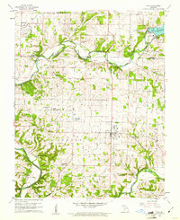 1960 Nixa1961 Print · USGSThe Ozark foothills south of Springfield appear here in the early 1960s as a landscape of rural family cemeteries and creek-side settlements. Genealogists can trace local history through landmarks like Union Chapel, McConnell Cem, and the historic Frazier Bridge.5 unique versions available
 - 1960 Map of Republic, 1961 Print
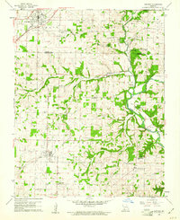 1960 Republic1961 Print · USGSSouthwest Missouri at the start of the 1960s reveals a landscape still deeply connected to its Civil War history and rural roots. Genealogists and historians can trace family locations through numerous sites like Wise Hill Cem, the historic Ray House, and the Wilson Creek Battlefield.4 unique versions available
 - 1964 Map of Harrison
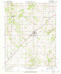
 1964 Harrison1964 Print · USGSThe Ozark and Boston Mountains of Arkansas and Missouri are captured here in the mid-sixties, showing the rugged highlands before extensive modern development. Genealogists and historians can trace family-named peaks like Gaither Mountain and follow the St Louis-San Francisco RR through Monett and Purdy.
 - 1969 Map of Billings, 1971 Print
 1969 Billings1971 Print · USGSThe Missouri prairie south of Springfield is captured here in the late sixties, centered on the rail junction at Billings. Genealogists and local historians can locate several rural burial grounds and churches, including St Peters Cem, Smart Cem, and Blades Chapel.2 unique versions available
End of results
Showing maps 1-4 of 4
Top cities of Christian County
- Nixa historical maps
- Ozark historical maps
- Clever historical maps
- Sparta historical maps
- Billings historical maps
- Highlandville historical maps
See more
Frequently asked questions
- What are the different types of historical maps available for Christian County?
- What is the oldest map of Christian County?
- Where can I purchase historical maps of Christian County for my home or office?
- Where can I download high-res historical maps of Christian County?
- Are there historical topographic maps available for Christian County?
- Is there historical aerial imagery available for Christian County?
- Where are historical maps of Christian County sourced from?