1930s Maps of Christian County, Missouri
Explore 3 historic maps of Christian County from the 1930s. These maps offer a rare glimpse into what life looked like during the 1930s — showing old roads, neighborhoods, homes, and landmarks that have changed or disappeared over time.
Whether you're researching your family's past, planning a metal detecting trip, or studying how Christian County's landscape evolved across the 1930s, these high-resolution maps are a powerful tool for exploring the history of this region.
- Focus on a specific era: All maps on this page are from the 1930s, giving you a focused view of this time period.
- See what’s changed: Compare century-old streets, trails, and buildings to today's modern landscape using overlays and satellite layers.
- Research with precision: Use these maps for genealogy, historical research, land use analysis, or educational projects.
- View, download, or print: Maps are fully viewable online in high resolution, and can be downloaded or printed for your own records.
Start exploring Christian County's history through authentic maps from the 1930s. This is your window into the past.
Christian County, MO maps
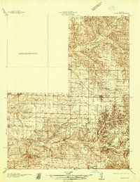
(3)- 1937 Map of Bradleyville
 1937 Bradleyville1937 Print · USGSDouglas County in the late 1930s was a landscape of remote hollows and high ridges connected by a network of one-room schools and small post offices. Trace family roots at Huffman Cem or locate forgotten community hubs like Old Merritt and Lone Star Sch.
 - 1937 Map of Ozark
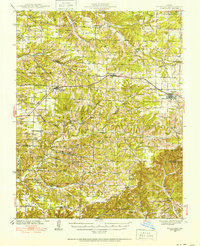
 1937 Ozark1937 Print · USGSChristian and Greene Counties are captured here in the mid-1930s, showing a landscape of river-valley farms and small railroad towns. Genealogists can trace family names through dozens of rural landmarks like Roller Cemetery, Riverside Inn, and the Whiteoak Church.
 - 1939 Map of Fordland
 1939 Fordland1939 Print · USGSThe Ozark plateau in the late 1930s is revealed as a dense network of ridge-top rail towns and valley settlements. Genealogists can trace family roots through numerous schools and churches like Cave Spring Sch, Taylor Cem, and the community of Elkhead.2 unique versions available
End of results
Showing maps 1-3 of 3
Top cities of Christian County
- Nixa historical maps
- Ozark historical maps
- Clever historical maps
- Sparta historical maps
- Billings historical maps
- Highlandville historical maps
See more
Frequently asked questions
- What are the different types of historical maps available for Christian County?
- What is the oldest map of Christian County?
- Where can I purchase historical maps of Christian County for my home or office?
- Where can I download high-res historical maps of Christian County?
- Are there historical topographic maps available for Christian County?
- Is there historical aerial imagery available for Christian County?
- Where are historical maps of Christian County sourced from?