1970s Maps of Christian County, Missouri
Explore 7 historic maps of Christian County from the 1970s. These maps offer a rare glimpse into what life looked like during the 1970s — showing old roads, neighborhoods, homes, and landmarks that have changed or disappeared over time.
Whether you're researching your family's past, planning a metal detecting trip, or studying how Christian County's landscape evolved across the 1970s, these high-resolution maps are a powerful tool for exploring the history of this region.
- Focus on a specific era: All maps on this page are from the 1970s, giving you a focused view of this time period.
- See what’s changed: Compare century-old streets, trails, and buildings to today's modern landscape using overlays and satellite layers.
- Research with precision: Use these maps for genealogy, historical research, land use analysis, or educational projects.
- View, download, or print: Maps are fully viewable online in high resolution, and can be downloaded or printed for your own records.
Start exploring Christian County's history through authentic maps from the 1970s. This is your window into the past.
Christian County, MO maps
(7)- 1970 Map of Rogersville, 1971 Print
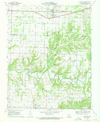 1970 Rogersville1971 Print · USGSRogersville and the surrounding Ozark townships are captured here at the end of the sixties as rural life centered on the railroad and local creeks. Researchers can trace family roots through numerous country burial grounds and churches like Holland Cem, Roller Cem, and Grace Gospel Ch.3 unique versions available
 - 1970 Map of Ozark, 1971 Print
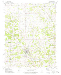
 1970 Ozark1971 Print · USGSChristian County at the start of the seventies reveals a landscape where the river-and-rail economy of Ozark meets the karst terrain of the Missouri hills. Trace local family history through numerous burial grounds like Weaver Cem and Pembina Cem, or find landmarks like Smallin Cave and the Drag Strip.3 unique versions available
 - 1974 Map of Crane, 1977 Print
 1974 Crane1977 Print · USGSStone County and the settlement of Crane are documented here in the mid-seventies, showing a landscape defined by railroad corridors and spring-fed hollows. Family historians can locate several local burial grounds and churches, including the Masonic Cem, Hood Cem, and Shiloh Ch.
 - 1979 Map of Nixa, 1981 Print
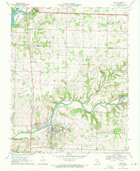
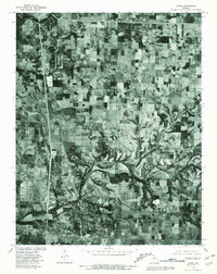
 1979 Nixa1981 Print · USGSNixa and the Christian County countryside appear in this late-seventies orthophoto just as suburban growth began to meet traditional Missouri farmland. Genealogists and historians can trace old property lines and the early footprints of Nixa, Battlefield, and the water's edge at Lake Springfield.
 - 1979 Map of Republic, 1981 Print
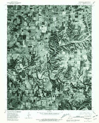
 1979 Republic1981 Print · USGSGreene and Christian counties appear at a moment of rural transition in the late seventies. Family historians and researchers can trace land patterns around Republic, Clever, and the small settlement of Boaz near the winding James River.
 - 1979 Map of Ozark, 1981 Print
 1979 Ozark1981 Print · USGSChristian County, Missouri, at the end of the seventies shows a landscape defined by traditional farming and the emerging growth of Ozark. Genealogists and local historians can trace the property lines and rural crossroads around Mentor, Cassidy, and the banks of Finley Creek.
 - 1979 Map of Rogersville, 1981 Print
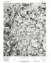
 1979 Rogersville1981 Print · USGSThe Missouri countryside south of the Springfield area is captured here in the late seventies through detailed aerial photoimagery. Researchers can trace the rural layouts of Rogersville, Sparta, and Cody alongside the winding course of Finley Creek.
End of results
Showing maps 1-7 of 7
Top cities of Christian County
- Nixa historical maps
- Ozark historical maps
- Clever historical maps
- Sparta historical maps
- Billings historical maps
- Highlandville historical maps
See more
Frequently asked questions
- What are the different types of historical maps available for Christian County?
- What is the oldest map of Christian County?
- Where can I purchase historical maps of Christian County for my home or office?
- Where can I download high-res historical maps of Christian County?
- Are there historical topographic maps available for Christian County?
- Is there historical aerial imagery available for Christian County?
- Where are historical maps of Christian County sourced from?