1940s Maps of Claycomo, Missouri
Explore 3 historic maps of Claycomo from the 1940s. These maps offer a rare glimpse into what life looked like during the 1940s — showing old roads, neighborhoods, homes, and landmarks that have changed or disappeared over time.
Whether you're researching your family's past, planning a metal detecting trip, or studying how Claycomo's landscape evolved across the 1940s, these high-resolution maps are a powerful tool for exploring the history of this region.
- Focus on a specific era: All maps on this page are from the 1940s, giving you a focused view of this time period.
- See what’s changed: Compare century-old streets, trails, and buildings to today's modern landscape using overlays and satellite layers.
- Research with precision: Use these maps for genealogy, historical research, land use analysis, or educational projects.
- View, download, or print: Maps are fully viewable online in high resolution, and can be downloaded or printed for your own records.
Start exploring Claycomo's history through authentic maps from the 1940s. This is your window into the past.
Claycomo, MO maps
(3)- 1940 Map of Liberty
 1940 Liberty1940 Print · USGSClay County at the dawn of the 1940s shows a dense network of river-bottom railroads and hilltop college life. Genealogists can trace family landmarks like Withers Sch, the Odd Fellows Home, and the Depression-era Federal Transient Camp.2 unique versions available
 - 1940 Map of North Kansas City
 1940 North Kansas City1940 Print · USGSThe industrial riverfront and Clay County uplands are documented here during the mid-1930s as the regional transport network matured. Genealogists and researchers can locate family landmarks like New Stark Cem, Bethel Ch, and the many rural schoolhouses serving Gashland and Barry.2 unique versions available
 - 1948 Map of North Kansas City, 1958 Print
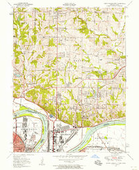 1948 North Kansas City1958 Print · USGSNorth Kansas City and the Missouri River corridor show a bustling mid-century mix of aviation, industry, and early suburban growth. Trace the development of Quindaro, the operations at Fairfax Airport, and local roots at Faubion Cemetery.
End of results
Showing maps 1-3 of 3
Top cities near Claycomo
- Kansas City historical maps
- Overland Park historical maps
- Kansas City historical maps
- Independence historical maps
- Lee's Summit historical maps
- Blue Springs historical maps
See more
Frequently asked questions
- What are the different types of historical maps available for Claycomo?
- What is the oldest map of Claycomo?
- Where can I purchase historical maps of Claycomo for my home or office?
- Where can I download high-res historical maps of Claycomo?
- Are there historical topographic maps available for Claycomo?
- Is there historical aerial imagery available for Claycomo?
- Where are historical maps of Claycomo sourced from?