1980s Maps of Malden, Missouri
Explore 3 historic maps of Malden from the 1980s. These maps offer a rare glimpse into what life looked like during the 1980s — showing old roads, neighborhoods, homes, and landmarks that have changed or disappeared over time.
Whether you're researching your family's past, planning a metal detecting trip, or studying how Malden's landscape evolved across the 1980s, these high-resolution maps are a powerful tool for exploring the history of this region.
- Focus on a specific era: All maps on this page are from the 1980s, giving you a focused view of this time period.
- See what’s changed: Compare century-old streets, trails, and buildings to today's modern landscape using overlays and satellite layers.
- Research with precision: Use these maps for genealogy, historical research, land use analysis, or educational projects.
- View, download, or print: Maps are fully viewable online in high resolution, and can be downloaded or printed for your own records.
Start exploring Malden's history through authentic maps from the 1980s. This is your window into the past.
Malden, MO maps
(3)- 1983 Map of Poplar Bluff
 1983 Poplar Bluff1983 Print · USGSSoutheast Missouri in the early 1980s reveals a landscape defined by the Ozark foothills and the complex drainage systems of the Bootheel. Researchers can trace the rail corridors of the Missouri Pacific RR through Poplar Bluff or locate rural sites like Wilhelmina Church and Lone Hill Lookout.
 - 1984 Map of Valley Ridge
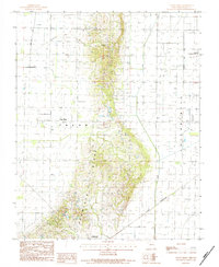 1984 Valley Ridge1984 Print · USGSDunklin County is seen during the early eighties as agricultural and transit networks expanded across the Bootheel. Researchers can trace the path of the St Louis Southwestern railroad or locate local landmarks like Crowleys Ridge and Bethany.
 - 1985 Map of Sikeston, 1986 Print
 1985 Sikeston1986 Print · USGSThe Missouri Bootheel and the four-state river convergence are captured in the mid-eighties as the modern agricultural and rail networks matured. Researchers can locate regional landmarks like the Towosahgy State Historic Site, Oak Grove Cem, and towns along the St Louis Southwestern Railroad.2 unique versions available
End of results
Showing maps 1-3 of 3
Top cities near Malden
- Dexter historical maps
- Piggott historical maps
- Campbell historical maps
- Bernie historical maps
- Clarkton historical maps
- Gideon historical maps
See more
Top neighborhoods of Malden
Frequently asked questions
- What are the different types of historical maps available for Malden?
- What is the oldest map of Malden?
- Where can I purchase historical maps of Malden for my home or office?
- Where can I download high-res historical maps of Malden?
- Are there historical topographic maps available for Malden?
- Is there historical aerial imagery available for Malden?
- Where are historical maps of Malden sourced from?