Old Maps of Malden, Missouri for Genealogy
Trace your family roots with 20 historic maps of Malden. These high-res maps reveal old neighborhoods, homesites, landmarks, and streets — helping you uncover where your ancestors lived and how the area evolved over time.
- Explore historic neighborhoods: Identify where your relatives may have lived in the 1800s or 1900s.
- Compare maps over time: Trace the changes in streets, buildings, and landmarks for multi-generational research.
- Perfect for genealogy & ancestry research: Used by family historians and researchers to map out lineage and migration.
These maps are an incredible resource for exploring your personal connection to Malden's past.
Malden, MO maps
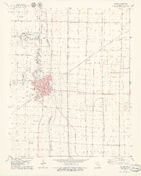
(20)- 1940 Map of Malden, 1942 Print
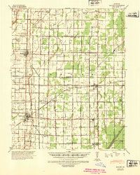 1940 Malden1942 Print · USGSIn the Missouri Bootheel during the early 1940s, a vast network of drainage ditches transformed the landscape for farming and rail commerce. Researchers can trace rural life through dozens of named landmarks like Sugar Tree Ch & Sch, Stephenson Cem, and Tallapoosa.
 - 1940 Map of Valley Ridge, 1943 Print
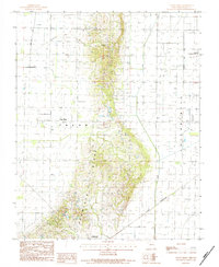
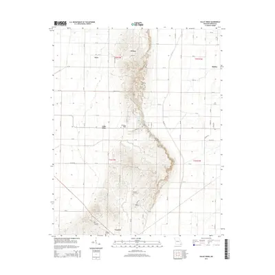
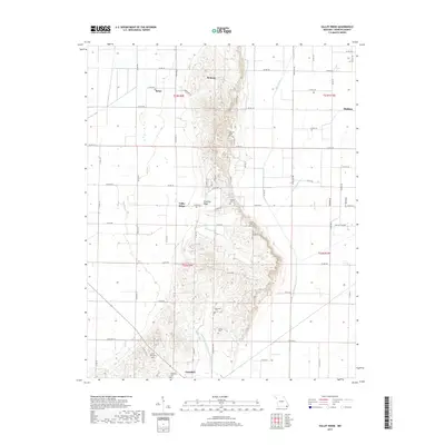
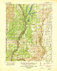 1940 Valley Ridge1943 Print · USGSDunklin and Butler counties come to life in the early 1940s, where the St Francis River winds through a landscape of new drainage ditches and high ridges. Researchers can locate family landmarks like Stephens Cem or trace old river crossings at Higginbothams Ferry.
 - 1956 Map of Valley Ridge
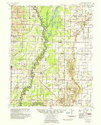 1956 Valley Ridge1956 Print · USGSDunklin and Butler counties in the mid-fifties show a landscape shaped by river transport and extensive drainage projects. Genealogists can locate many rural social hubs like Depoyster Ch & Sch, Higginbothams Ferry, and the St Louis Southwestern Railroad.
 - 1956 Map of Malden
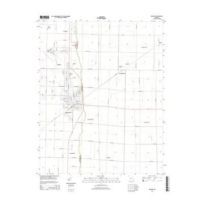
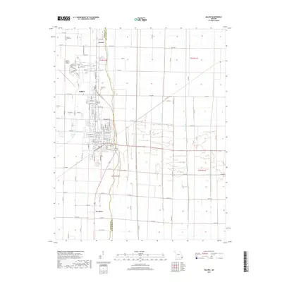
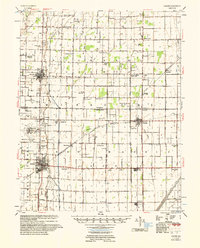 1956 Malden1956 Print · USGSThe Missouri bootheel in the mid-1950s reveals a highly engineered landscape where drainage ditches and rail lines shaped every town and farm. Genealogists can locate family landmarks like Poplin Sch & Cem, Stones Chapel Cem, and the Malden Air Force Base.
 - 1956 Map of Dyersburg, 1960 Print
 1956 Dyersburg1960 Print · USGSThe Four Rivers region comes alive in the mid-fifties, capturing the intricate borderlands of Tennessee, Kentucky, and Missouri. Genealogists and historians can trace the rail-and-river networks connecting Dyersburg, Caruthersville, and the shoreline of Reelfoot Lake.4 unique versions available
 - 1957 Map of Poplar Bluff, 1968 Print
 1957 Poplar Bluff1968 Print · USGSThe Missouri-Arkansas border region is captured here as the timber and rail industries shaped the Ozark foothills. Genealogists and historians can trace the Missouri Pacific Railroad through river towns like Pocahontas, Greenville, and Van Buren.3 unique versions available
 - 1959 Map of Poplar Bluff
 1959 Poplar Bluff1959 Print · USGSThe Missouri Ozarks and Arkansas borderlands meet in this late 1950s study of the region's diverse terrain and rail-fed towns. Researchers can trace the path of the Missouri Pacific Railroad through Poplar Bluff or locate smaller settlements like Birch Tree and Myrtle.
 - 1960 Map of Poplar Bluff
 1960 Poplar Bluff1960 Print · USGSSoutheast Missouri and Northeast Arkansas are captured here during the post-war era, showing the transition from the Ozark highlands to the Delta. Genealogists and historians can trace rail corridors like the St. Louis Southwestern RR and remote settlements such as Birch Tree and Warm Springs.
 - 1978 Map of Malden, 1979 Print
 1978 Malden1979 Print · USGSThe Missouri Bootheel in the late seventies reveals a landscape of engineered drainage and rail-side growth. Genealogists and local historians can locate several family burial grounds like Macedonia Cem and trace the legacy of Townley and the Malden Municipal Airport.
 - 1983 Map of Poplar Bluff
 1983 Poplar Bluff1983 Print · USGSSoutheast Missouri in the early 1980s reveals a landscape defined by the Ozark foothills and the complex drainage systems of the Bootheel. Researchers can trace the rail corridors of the Missouri Pacific RR through Poplar Bluff or locate rural sites like Wilhelmina Church and Lone Hill Lookout.
 - 1984 Map of Valley Ridge
 1984 Valley Ridge1984 Print · USGSDunklin County is seen during the early eighties as agricultural and transit networks expanded across the Bootheel. Researchers can trace the path of the St Louis Southwestern railroad or locate local landmarks like Crowleys Ridge and Bethany.
 - 1985 Map of Sikeston, 1986 Print
 1985 Sikeston1986 Print · USGSThe Missouri Bootheel and the four-state river convergence are captured in the mid-eighties as the modern agricultural and rail networks matured. Researchers can locate regional landmarks like the Towosahgy State Historic Site, Oak Grove Cem, and towns along the St Louis Southwestern Railroad.2 unique versions available
 - 2011 Map of Valley Ridge, 2011 Print
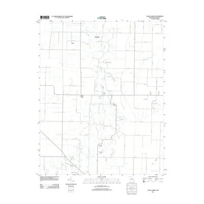 2011 Valley Ridge2011 Print · USGSCovers Malden, including Campbell, Valley Ridge, and other nearby areas
 - 2012 Map of Malden, 2012 Print
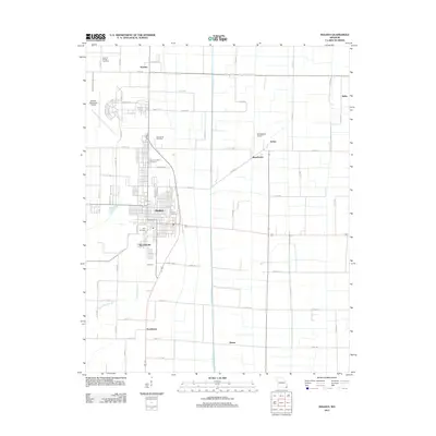 2012 Malden2012 Print · USGSCovers Malden, including Baxter, Spoonerville, and other nearby areas
 - 2015 Map of Valley Ridge, 2015 Print
 2015 Valley Ridge2015 Print · USGSCovers Malden, including Campbell, Valley Ridge, and other nearby areas
 - 2015 Map of Malden, 2015 Print
 2015 Malden2015 Print · USGSCovers Malden, including Baxter, Spoonerville, and other nearby areas
 - 2017 Map of Valley Ridge, 2017 Print
 2017 Valley Ridge2017 Print · USGSCovers Malden, including Campbell, Valley Ridge, and other nearby areas
 - 2017 Map of Malden, 2017 Print
 2017 Malden2017 Print · USGSCovers Malden, including Baxter, Spoonerville, and other nearby areas
 - 2021 Map of Malden, 2021 Print
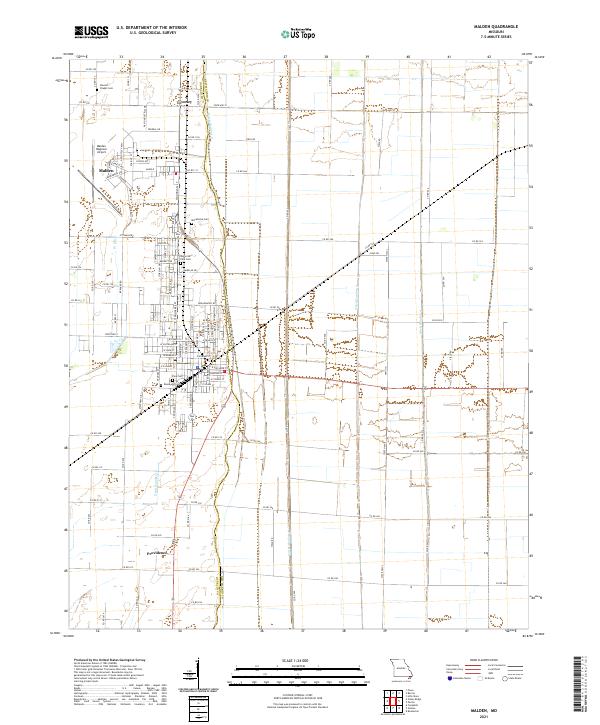 2021 Malden2021 Print · USGSThe Missouri Bootheel's engineered landscape is on full display here in the early 2020s, showing a grid of drainage canals and airfields. Researchers can locate local burial grounds like Stevens Chapel Cem and trace the agricultural footprint near Townley and Providence.
 - 2021 Map of Valley Ridge, 2021 Print
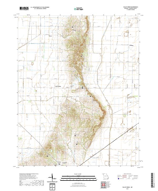 2021 Valley Ridge2021 Print · USGSDunklin County, Missouri, is dominated by the unique elevation of Crowleys Ridge rising above the surrounding drained lowlands in this recent survey. Genealogists and local historians can locate numerous rural burial grounds including Vincent Cem, Riddle Hill Cem, and Gunnels Cem.
End of results
Showing maps 1-20 of 20
Top cities near Malden
- Dexter historical maps
- Piggott historical maps
- Campbell historical maps
- Bernie historical maps
- Clarkton historical maps
- Gideon historical maps
See more
Top neighborhoods of Malden
Frequently asked questions
- What are the different types of historical maps available for Malden?
- What is the oldest map of Malden?
- Where can I purchase historical maps of Malden for my home or office?
- Where can I download high-res historical maps of Malden?
- Are there historical topographic maps available for Malden?
- Is there historical aerial imagery available for Malden?
- Where are historical maps of Malden sourced from?