1930s Maps of Franklin County, Missouri
Explore 7 historic maps of Franklin County from the 1930s. These maps offer a rare glimpse into what life looked like during the 1930s — showing old roads, neighborhoods, homes, and landmarks that have changed or disappeared over time.
Whether you're researching your family's past, planning a metal detecting trip, or studying how Franklin County's landscape evolved across the 1930s, these high-resolution maps are a powerful tool for exploring the history of this region.
- Focus on a specific era: All maps on this page are from the 1930s, giving you a focused view of this time period.
- See what’s changed: Compare century-old streets, trails, and buildings to today's modern landscape using overlays and satellite layers.
- Research with precision: Use these maps for genealogy, historical research, land use analysis, or educational projects.
- View, download, or print: Maps are fully viewable online in high resolution, and can be downloaded or printed for your own records.
Start exploring Franklin County's history through authentic maps from the 1930s. This is your window into the past.
Franklin County, MO maps
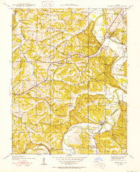
(7)- 1934 Map of Meramec State Park, 1962 Print
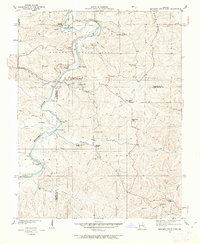 1934 Meramec State Park1962 Print · USGSThe Meramec River valley in the mid-1930s reveals a region transitioning from isolated settlements to a destination for early 20th-century tourism. Genealogists and historians can trace defunct school districts like Pea Ridge Sch and Zion Sch, locate the CCC Camp, or find old river crossings at Hamilton Ford.2 unique versions available
 - 1935 Map of Gerald
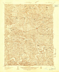 1935 Gerald1935 Print · USGSThe borderlands of Gasconade and Franklin counties are seen here in the mid-1930s as the Chicago Rock Island and Pacific railroad connects growing towns like Gerald and Rosebud. Local historians can trace dozens of rural school sites, including Buffalo Ridge School and Hinton Sch, alongside family-named landmarks and the meandering Bourbeuse River.
 - 1936 Map of Hermann
 1936 Hermann1936 Print · USGSThe riverfront at Hermann and the surrounding hill country are captured here in the mid-1930s. Genealogists can trace family roots through an extensive network of rural landmarks, from the Swiss Sch and St Josephs Ch to the small settlement of Detmold.
 - 1937 Map of Pacific
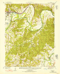 1937 Pacific1937 Print · USGSIn the late 1930s, the Meramec and Big River valleys formed a landscape of rail junctions and rural infirmaries. You can trace the rail lines at Pacific, locate the C C C Camp, or find local schools like McNamee Sch and La Barque Sch.4 unique versions available
 - 1937 Map of Weldon Spring
 1937 Weldon Spring1937 Print · USGSThe Missouri River bottoms and the rising hills of St. Charles County are shown here in the late thirties, just as industrial and parkland developments began to reshape the region. Genealogists can locate several family burial grounds like Wolf Cem and Howell Cem, alongside rural centers such as Centaur Station and Toonerville.
 - 1937 Map of Meramec State Park
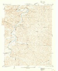 1937 Meramec State Park1937 Print · USGSThe Missouri Ozarks are captured here in the mid-1930s, showing the early infrastructure of Meramec State Park and its surrounding river communities. Genealogists and hikers can trace old homesteads and local landmarks like Reedville Ch, the CCC Camp, and the historic Sappington Bridge river crossing.
 - 1938 Map of Cedar Hill
 1938 Cedar Hill1938 Print · USGSJefferson County before the Second World War was a network of river-bottom mills and ridge-top schools connected by winding country roads. Genealogists can trace family footprints at Morse Mill, the MCCULLOCH FORD crossing, and rural schools like Bethlehem Sch.2 unique versions available
End of results
Showing maps 1-7 of 7
Top cities of Franklin County
- Washington historical maps
- Union historical maps
- Pacific historical maps
- Gray Summit historical maps
- New Haven historical maps
- Gerald historical maps
See more
Frequently asked questions
- What are the different types of historical maps available for Franklin County?
- What is the oldest map of Franklin County?
- Where can I purchase historical maps of Franklin County for my home or office?
- Where can I download high-res historical maps of Franklin County?
- Are there historical topographic maps available for Franklin County?
- Is there historical aerial imagery available for Franklin County?
- Where are historical maps of Franklin County sourced from?