1950s Maps of Greene County, Missouri
Explore 6 historic maps of Greene County from the 1950s. These maps offer a rare glimpse into what life looked like during the 1950s — showing old roads, neighborhoods, homes, and landmarks that have changed or disappeared over time.
Whether you're researching your family's past, planning a metal detecting trip, or studying how Greene County's landscape evolved across the 1950s, these high-resolution maps are a powerful tool for exploring the history of this region.
- Focus on a specific era: All maps on this page are from the 1950s, giving you a focused view of this time period.
- See what’s changed: Compare century-old streets, trails, and buildings to today's modern landscape using overlays and satellite layers.
- Research with precision: Use these maps for genealogy, historical research, land use analysis, or educational projects.
- View, download, or print: Maps are fully viewable online in high resolution, and can be downloaded or printed for your own records.
Start exploring Greene County's history through authentic maps from the 1950s. This is your window into the past.
Greene County, MO maps
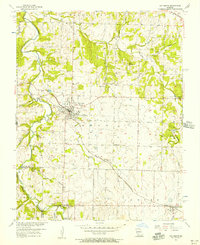
(6)- 1954 Map of Springfield
 1954 Springfield1954 Print · USGSThe Missouri Ozarks are captured here during the post-war era, showing the expansion of Springfield and the surrounding river valleys. Genealogists and historians can trace local landmarks like Mount Comfort Cemetery and the Fort Leonard Wood military grounds.6 unique versions available
 - 1956 Map of Ash Grove, 1957 Print
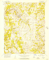
 1956 Ash Grove1957 Print · USGSWestern Greene County in the mid-1950s is defined by the crossing of the St Louis San Francisco railroad and the winding Sac River. Genealogists can trace family footprints through sites like Hamilton Cem, Johns Chapel, and the established streets of Ash Grove.2 unique versions available
 - 1956 Map of Walnut Grove, 1957 Print
 1956 Walnut Grove1957 Print · USGSWalnut Grove and the surrounding Missouri countryside are captured in the mid-fifties, during a time when rural life revolved around local churches and the railroad. Researchers can trace family roots at Green Lawn Cem, explore the old rail stop at Graydon Springs, or locate the Quarries at Phenix.2 unique versions available
 - 1956 Map of Everton, 1957 Print
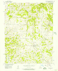
 1956 Everton1957 Print · USGSEverton and the surrounding Rock Prairie uplands are captured here in the mid-fifties, showing the vital link between the St Louis San Francisco railroad and local agriculture. Researchers can trace rural life through sites like Hopewell Sch, Liberty Ch, and the Hood Cem.2 unique versions available
 - 1958 Map of Springfield
 1958 Springfield1958 Print · USGSThe Missouri Ozarks are captured during the mid-century era of growth, centered on the bustling hub of Springfield. Genealogists and historians can trace family roots through numerous landmarks like Ebenezer Church, Stockton Cem, and the various county courthouses.
 - 1959 Map of Springfield
 1959 Springfield1959 Print · USGSThe Missouri Ozarks are captured here during a decade of postwar growth and increasing highway connectivity. Researchers can trace the legacy of the St Louis-San Francisco RR and locate early sites in Springfield, Lebanon, and Mountain Grove.
End of results
Showing maps 1-6 of 6
Top cities of Greene County
- Springfield historical maps
- Republic historical maps
- Willard historical maps
- Battlefield historical maps
- Strafford historical maps
- Ash Grove historical maps
See more
Frequently asked questions
- What are the different types of historical maps available for Greene County?
- What is the oldest map of Greene County?
- Where can I purchase historical maps of Greene County for my home or office?
- Where can I download high-res historical maps of Greene County?
- Are there historical topographic maps available for Greene County?
- Is there historical aerial imagery available for Greene County?
- Where are historical maps of Greene County sourced from?