1960s Maps of Greene County, Missouri
Explore 12 historic maps of Greene County from the 1960s. These maps offer a rare glimpse into what life looked like during the 1960s — showing old roads, neighborhoods, homes, and landmarks that have changed or disappeared over time.
Whether you're researching your family's past, planning a metal detecting trip, or studying how Greene County's landscape evolved across the 1960s, these high-resolution maps are a powerful tool for exploring the history of this region.
- Focus on a specific era: All maps on this page are from the 1960s, giving you a focused view of this time period.
- See what’s changed: Compare century-old streets, trails, and buildings to today's modern landscape using overlays and satellite layers.
- Research with precision: Use these maps for genealogy, historical research, land use analysis, or educational projects.
- View, download, or print: Maps are fully viewable online in high resolution, and can be downloaded or printed for your own records.
Start exploring Greene County's history through authentic maps from the 1960s. This is your window into the past.
Greene County, MO maps
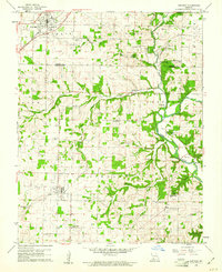
(12)- 1960 Map of Brookline, 1961 Print
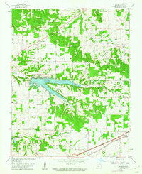
 1960 Brookline1961 Print · USGSGreene County is captured during a period of infrastructure expansion in the early sixties as new highways were being built alongside established rail lines. Genealogists and local historians can locate several burial sites like Evergreen Cemetery and trace the original ST LOUIS SAN FRANCISCO rail route through Republic and Brookline.5 unique versions available
 - 1960 Map of Nixa, 1961 Print
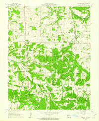
 1960 Nixa1961 Print · USGSThe Ozark foothills south of Springfield appear here in the early 1960s as a landscape of rural family cemeteries and creek-side settlements. Genealogists can trace local history through landmarks like Union Chapel, McConnell Cem, and the historic Frazier Bridge.5 unique versions available
 - 1960 Map of Springfield, 1961 Print
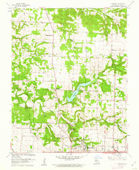
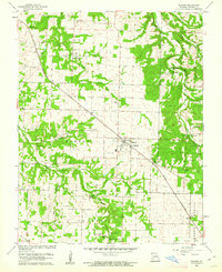
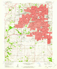 1960 Springfield1961 Print · USGSSpringfield and its surrounding Greene County townships appear in the early sixties during a season of post-war growth. Researchers can trace institutional roots at Southwest Missouri State College, explore the FEDERAL MEDICAL CENTER, or locate family sites near Hazelwood Cemetery and Bethany Ch.4 unique versions available
 - 1960 Map of Galloway, 1961 Print
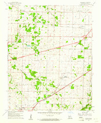
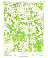
 1960 Galloway1961 Print · USGSEastern Greene County at the dawn of the 1960s shows a mix of rural heritage and emerging city growth. Researchers can trace family roots through numerous landmarks like Kinser Chapel, the St Louis San Francisco railroad, and Bodenhamer Cem.4 unique versions available
 - 1960 Map of Republic, 1961 Print
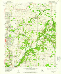
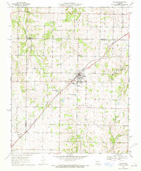
 1960 Republic1961 Print · USGSSouthwest Missouri at the start of the 1960s reveals a landscape still deeply connected to its Civil War history and rural roots. Genealogists and historians can trace family locations through numerous sites like Wise Hill Cem, the historic Ray House, and the Wilson Creek Battlefield.4 unique versions available
 - 1961 Map of Pleasant Hope, 1962 Print
 1961 Pleasant Hope1962 Print · USGSThe Polk and Greene County borderlands in the early sixties reveal a landscape of small rural settlements and river-valley farms. Genealogists and local historians can trace the foundations of these communities through landmarks like Brighton, New Hope Sch, and the Tiller Cem.2 unique versions available
 - 1961 Map of Ebenezer, 1962 Print
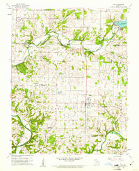
 1961 Ebenezer1962 Print · USGSNorth of Springfield in the early sixties, the landscape transitions from growing suburbs to established prairie farms and river valleys. Researchers can trace family roots at Greenlawn Cemetery or locate landmarks like Fantastic Caverns and McDaniel Lake.3 unique versions available
 - 1961 Map of Morrisville, 1962 Print
 1961 Morrisville1962 Print · USGSThe rural border of Polk and Greene Counties comes into focus in the early sixties, centered on the village of Morrisville and the winding Little Sac River. Researchers can trace the St Louis - San Francisco rail line and locate community landmarks like Oakville Ch and Gays Chapel.2 unique versions available
 - 1961 Map of Bassville, 1962 Print
 1961 Bassville1962 Print · USGSNortheast of Springfield in the early sixties, this area shows the recently established Fellows Lake and the rural crossroads of the day. Researchers can locate family landmarks like Salem Cem, Hickory Barren, and the old Pleasant View Sch.3 unique versions available
 - 1961 Map of Willard, 1962 Print
 1961 Willard1962 Print · USGSGreene County, Missouri, is captured in the early sixties as the railroad town of Willard began its modern growth. Researchers can trace rural lineages through the many named family sites, including Mt Pleasant Ch, Wesley Cem, and the old Hackney Mill Bridge.4 unique versions available
 - 1969 Map of Billings, 1971 Print
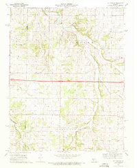
 1969 Billings1971 Print · USGSThe Missouri prairie south of Springfield is captured here in the late sixties, centered on the rail junction at Billings. Genealogists and local historians can locate several rural burial grounds and churches, including St Peters Cem, Smart Cem, and Blades Chapel.2 unique versions available
 - 1969 Map of Halltown NE, 1971 Print
 1969 Halltown NE1971 Print · USGSThe Missouri Ozarks are captured here in the late sixties as modern highways began to bypass traditional hubs like Halltown. Researchers can locate several family burial grounds such as Batson Cem and Garoutte Cem alongside landmarks like the Downing Farm Landing Field.2 unique versions available
End of results
Showing maps 1-12 of 12
Top cities of Greene County
- Springfield historical maps
- Republic historical maps
- Willard historical maps
- Battlefield historical maps
- Strafford historical maps
- Ash Grove historical maps
See more
Frequently asked questions
- What are the different types of historical maps available for Greene County?
- What is the oldest map of Greene County?
- Where can I purchase historical maps of Greene County for my home or office?
- Where can I download high-res historical maps of Greene County?
- Are there historical topographic maps available for Greene County?
- Is there historical aerial imagery available for Greene County?
- Where are historical maps of Greene County sourced from?