1930s Maps of Howell County, Missouri
Explore 2 historic maps of Howell County from the 1930s. These maps offer a rare glimpse into what life looked like during the 1930s — showing old roads, neighborhoods, homes, and landmarks that have changed or disappeared over time.
Whether you're researching your family's past, planning a metal detecting trip, or studying how Howell County's landscape evolved across the 1930s, these high-resolution maps are a powerful tool for exploring the history of this region.
- Focus on a specific era: All maps on this page are from the 1930s, giving you a focused view of this time period.
- See what’s changed: Compare century-old streets, trails, and buildings to today's modern landscape using overlays and satellite layers.
- Research with precision: Use these maps for genealogy, historical research, land use analysis, or educational projects.
- View, download, or print: Maps are fully viewable online in high resolution, and can be downloaded or printed for your own records.
Start exploring Howell County's history through authentic maps from the 1930s. This is your window into the past.
Howell County, MO maps
(2)- 1938 Map of West Plains, 1954 Print
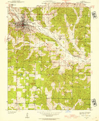 1938 West Plains1954 Print · USGSWest Plains was a bustling Missouri rail town in the late 1930s, centered in the Howell Valley. Genealogists can locate family landmarks such as the County Cem, rural schools like Renfrow Sch, and the St Louis San Francisco rail corridor.3 unique versions available
 - 1939 Map of Topaz
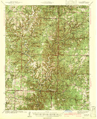 1939 Topaz1939 Print · USGSThe North Fork River valley in Douglas and Ozark counties is captured here in the late 1930s, showing a landscape defined by riverside mills and rural schools. Genealogists can trace family landmarks across Richville, Siloam Springs, and Hammonds Mill, or find remote sites like Mitts Cem and Little Zion Sch.3 unique versions available
End of results
Showing maps 1-2 of 2
Top cities of Howell County
- West Plains historical maps
- Mountain View historical maps
- Willow Springs historical maps
- Brandsville historical maps
Frequently asked questions
- What are the different types of historical maps available for Howell County?
- What is the oldest map of Howell County?
- Where can I purchase historical maps of Howell County for my home or office?
- Where can I download high-res historical maps of Howell County?
- Are there historical topographic maps available for Howell County?
- Is there historical aerial imagery available for Howell County?
- Where are historical maps of Howell County sourced from?