1930s Maps of Lee's Summit, Missouri
Explore 5 historic maps of Lee's Summit from the 1930s. These maps offer a rare glimpse into what life looked like during the 1930s — showing old roads, neighborhoods, homes, and landmarks that have changed or disappeared over time.
Whether you're researching your family's past, planning a metal detecting trip, or studying how Lee's Summit's landscape evolved across the 1930s, these high-resolution maps are a powerful tool for exploring the history of this region.
- Focus on a specific era: All maps on this page are from the 1930s, giving you a focused view of this time period.
- See what’s changed: Compare century-old streets, trails, and buildings to today's modern landscape using overlays and satellite layers.
- Research with precision: Use these maps for genealogy, historical research, land use analysis, or educational projects.
- View, download, or print: Maps are fully viewable online in high resolution, and can be downloaded or printed for your own records.
Start exploring Lee's Summit's history through authentic maps from the 1930s. This is your window into the past.
Lee's Summit, MO maps
(5)- 1933 Map of Blue Springs
 1933 Blue Springs1933 Print · USGSJackson County in the 1930s shows a landscape of rural schoolhouses and family farms connected by the Little Blue River. Researchers can trace ancestral property near Lobb Cemetery or locate vanished landmarks like Selsa and the Old Blue Springs Sch.
 - 1934 Map of Independence
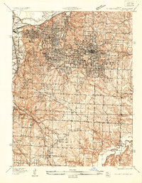 1934 Independence1934 Print · USGSIn Jackson County during the mid-1930s, the landscape around Independence shows a bustling network of river commerce and early highways. Researchers can trace the heritage of local institutions like the Jackson County Girls Home and historic sites such as Mt Washington Cem.2 unique versions available
 - 1934 Map of Lees Summit
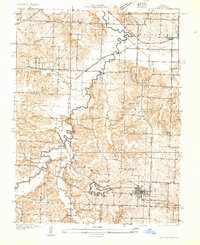
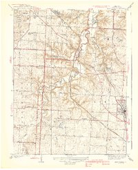
 1934 Lees Summit1934 Print · USGSJackson County during the mid-1930s is a landscape of winding river valleys and rural school districts centered around the growing hub of Lees Summit. Genealogists and historians can trace the locations of the Floral Hills Cemetery, early aviation at Richards Landing Field, and local stops like South Lee Sta.
 - 1934 Map of Woods Chapel
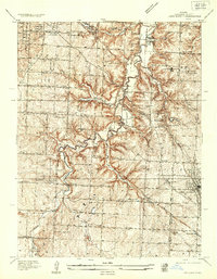
 1934 Woods Chapel1934 Print · USGSJackson County agriculture and river valley life are captured here in the mid-thirties, just as the region began to modernize. Researchers can trace rural school locations like Mason Sch and early lakeside developments at Lake Lotawana near the Little Blue River.2 unique versions available
 - 1939 Map of Lees Summit
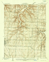
 1939 Lees Summit1939 Print · USGSJackson County in the late 1930s shows a landscape of rail-driven settlements and scattered country schools. Genealogists can locate family landmarks along the Chicago Rock Island and Pacific railroad, from Knobtown to the early streets of Lees Summit.3 unique versions available
End of results
Showing maps 1-5 of 5
Top cities near Lee's Summit
- Kansas City historical maps
- Kansas City historical maps
- Independence historical maps
- Blue Springs historical maps
- Raytown historical maps
- Grandview historical maps
See more
Top neighborhoods of Lee's Summit
Frequently asked questions
- What are the different types of historical maps available for Lee's Summit?
- What is the oldest map of Lee's Summit?
- Where can I purchase historical maps of Lee's Summit for my home or office?
- Where can I download high-res historical maps of Lee's Summit?
- Are there historical topographic maps available for Lee's Summit?
- Is there historical aerial imagery available for Lee's Summit?
- Where are historical maps of Lee's Summit sourced from?