1960s Maps of Lee's Summit, Missouri
Explore 6 historic maps of Lee's Summit from the 1960s. These maps offer a rare glimpse into what life looked like during the 1960s — showing old roads, neighborhoods, homes, and landmarks that have changed or disappeared over time.
Whether you're researching your family's past, planning a metal detecting trip, or studying how Lee's Summit's landscape evolved across the 1960s, these high-resolution maps are a powerful tool for exploring the history of this region.
- Focus on a specific era: All maps on this page are from the 1960s, giving you a focused view of this time period.
- See what’s changed: Compare century-old streets, trails, and buildings to today's modern landscape using overlays and satellite layers.
- Research with precision: Use these maps for genealogy, historical research, land use analysis, or educational projects.
- View, download, or print: Maps are fully viewable online in high resolution, and can be downloaded or printed for your own records.
Start exploring Lee's Summit's history through authentic maps from the 1960s. This is your window into the past.
Lee's Summit, MO maps
(6)- 1960 Map of Kansas City
 1960 Kansas City1960 Print · USGSMid-century Kansas and Missouri meet at the river forks, showing a sprawling rail-and-river economy during the 1950s growth era. Genealogists and researchers can trace tribal lands like the Kickapoo Indian Reservation or follow the early interstate corridors through Saint Joseph and Independence.3 unique versions available
 - 1961 Map of Lawrence
 1961 Lawrence1961 Print · USGSThe Kansas-Missouri borderland shows its mid-century transition from a rail-dependent agricultural region to a suburbanizing landscape. Genealogists can trace family footprints through numerous Cem sites and distinctive terrain landmarks like Graves Mound and Summers Mound.
 - 1963 Map of Lake Jacomo, 1964 Print
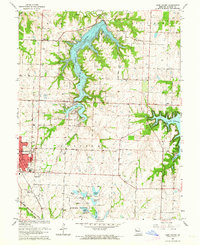 1963 Lake Jacomo1964 Print · USGSIn the early sixties, the eastern suburbs of Jackson County were taking shape around new reservoirs and established rail lines. Researchers can trace family sites and early infrastructure at Woods Chapel Cem, Prairie Lee Ch, and along the Missouri Pacific railroad.3 unique versions available
 - 1964 Map of Independence, 1965 Print
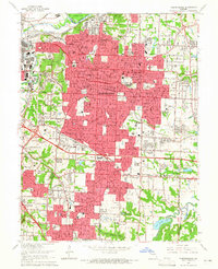 1964 Independence1965 Print · USGSMid-century Jackson County is captured here as the suburbs of Independence and Raytown expanded along the rail lines. Genealogists and historians can locate dozens of local schools and landmarks like Mt Washington Cemetery and the Drumm Institute.4 unique versions available
 - 1964 Map of Lees Summit, 1965 Print
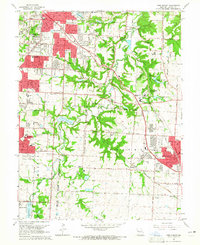 1964 Lees Summit1965 Print · USGSJackson County is shown at a moment of transition in the 1960s as suburban growth reaches toward the rural Little Blue River valley. Genealogists and local historians can trace family plots in Floral Hills Cemetery or locate old community hubs like Knobtown and South Lee.4 unique versions available
 - 1965 Map of Blue Springs, 1966 Print
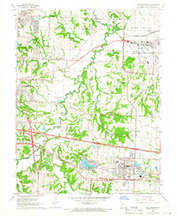 1965 Blue Springs1966 Print · USGSJackson County at the height of the mid-century shows the expanding footprint of East Independence and Blue Springs. Researchers can trace the massive Lake City Army Ammunition Plant and family-named landmarks like Lobb Cem and Stanley Cem.3 unique versions available
End of results
Showing maps 1-6 of 6
Top cities near Lee's Summit
- Kansas City historical maps
- Kansas City historical maps
- Independence historical maps
- Blue Springs historical maps
- Raytown historical maps
- Grandview historical maps
See more
Top neighborhoods of Lee's Summit
Frequently asked questions
- What are the different types of historical maps available for Lee's Summit?
- What is the oldest map of Lee's Summit?
- Where can I purchase historical maps of Lee's Summit for my home or office?
- Where can I download high-res historical maps of Lee's Summit?
- Are there historical topographic maps available for Lee's Summit?
- Is there historical aerial imagery available for Lee's Summit?
- Where are historical maps of Lee's Summit sourced from?