1960s Maps of Jefferson County, Missouri
Explore 10 historic maps of Jefferson County from the 1960s. These maps offer a rare glimpse into what life looked like during the 1960s — showing old roads, neighborhoods, homes, and landmarks that have changed or disappeared over time.
Whether you're researching your family's past, planning a metal detecting trip, or studying how Jefferson County's landscape evolved across the 1960s, these high-resolution maps are a powerful tool for exploring the history of this region.
- Focus on a specific era: All maps on this page are from the 1960s, giving you a focused view of this time period.
- See what’s changed: Compare century-old streets, trails, and buildings to today's modern landscape using overlays and satellite layers.
- Research with precision: Use these maps for genealogy, historical research, land use analysis, or educational projects.
- View, download, or print: Maps are fully viewable online in high resolution, and can be downloaded or printed for your own records.
Start exploring Jefferson County's history through authentic maps from the 1960s. This is your window into the past.
Jefferson County, MO maps
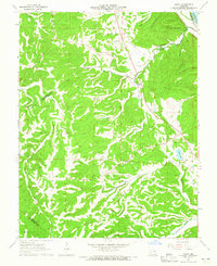
(10)- 1960 Map of De Soto, 1961 Print
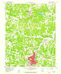 1960 De Soto1961 Print · USGSJefferson County was a landscape of winding creek valleys and rail-fed towns in the early sixties. Genealogists can trace family roots through several sites including Good Shepherd Cem, Victoria, and the campus of Mt St Clements College.2 unique versions available
 - 1960 Map of Vineland, 1961 Print
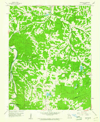 1960 Vineland1961 Print · USGSJefferson and St. Francois counties are shown here in the early sixties, as rural life centered around the Big River and the Missouri Pacific line. Researchers can trace family history through sites like Moontown Cem, the Sunrise Sch, and Valles Mines.2 unique versions available
 - 1962 Map of St. Louis
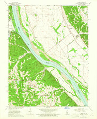
 1962 St. Louis1962 Print · USGSThe mid-century gateway to the west shows the metropolitan expansion of St Louis alongside its critical river confluences. Genealogists and historians can trace the rail corridors of the Missouri Pacific RR and settlements from Fulton to De Soto.
 - 1963 Map of St. Louis, 1970 Print
 1963 St. Louis1970 Print · USGSSt. Louis and its surrounding river valleys are captured here during the peak of mid-century suburban expansion and industrial activity. Trace the historic rail routes of the Norfolk and Western Ry or locate the St Louis Ordnance Plant and early stretches of US Highway 66.4 unique versions available
 - 1964 Map of Halifax, 1965 Print
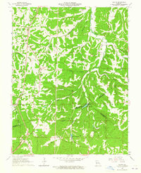 1964 Halifax1965 Print · USGSJefferson and St. Francois counties are captured in the mid-1960s as the local landscape transitions between historic mining and quiet rural life. Genealogists can trace family connections at the German Ch Cem, Byrd Cem, and the settlement at Valles Mines.2 unique versions available
 - 1964 Map of Festus, 1965 Print
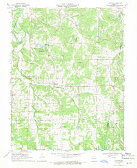
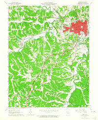 1964 Festus1965 Print · USGSJefferson County industrial and rail hubs are caught in detail during the mid-1960s. Researchers can trace family roots through sites like Rose Lawn Cem, Old Plattin Ch, and the streets of Festus and Crystal City.2 unique versions available
 - 1964 Map of Danby, 1965 Print
 1964 Danby1965 Print · USGSSte. Genevieve County in the mid-sixties remained a landscape of remote family cemeteries and wooded hollows. Genealogists can trace family names at Bockenkamp Cem and Moehler Cem, or follow the rail corridor of the St Louis San Francisco.2 unique versions available
 - 1964 Map of Selma, 1965 Print
 1964 Selma1965 Print · USGSThe Mississippi River divides Missouri and Illinois in the mid-1960s, cutting between bluff-side settlements and island bottomlands. Genealogists can trace family names at Cook Cem and Donnell Cem or locate the old Selma Sch.3 unique versions available
 - 1966 Map of St. Louis
 1966 St. Louis1966 Print · USGSThe St. Louis metropolitan area and its surrounding river valleys are captured here during the mid-sixties era of suburban growth and industrial strength. Genealogists and historians can trace the foundations of local communities through sites like Old Pioneer Cem, Parks College, and the Jefferson Barracks Military Reservation.
 - 1969 Map of Lonedell, 1971 Print
 1969 Lonedell1971 Print · USGSFranklin County in the late sixties reveals a landscape of quiet river valleys and rural community life before modern expansion. Genealogists can trace family footprints across Finney Cem, visit School R-14, or locate the historic Lonedell Lookout Tower.2 unique versions available
End of results
Showing maps 1-10 of 10
Frequently asked questions
- What are the different types of historical maps available for Jefferson County?
- What is the oldest map of Jefferson County?
- Where can I purchase historical maps of Jefferson County for my home or office?
- Where can I download high-res historical maps of Jefferson County?
- Are there historical topographic maps available for Jefferson County?
- Is there historical aerial imagery available for Jefferson County?
- Where are historical maps of Jefferson County sourced from?