1990s Maps of Jefferson County, Missouri
Explore 9 historic maps of Jefferson County from the 1990s. These maps offer a rare glimpse into what life looked like during the 1990s — showing old roads, neighborhoods, homes, and landmarks that have changed or disappeared over time.
Whether you're researching your family's past, planning a metal detecting trip, or studying how Jefferson County's landscape evolved across the 1990s, these high-resolution maps are a powerful tool for exploring the history of this region.
- Focus on a specific era: All maps on this page are from the 1990s, giving you a focused view of this time period.
- See what’s changed: Compare century-old streets, trails, and buildings to today's modern landscape using overlays and satellite layers.
- Research with precision: Use these maps for genealogy, historical research, land use analysis, or educational projects.
- View, download, or print: Maps are fully viewable online in high resolution, and can be downloaded or printed for your own records.
Start exploring Jefferson County's history through authentic maps from the 1990s. This is your window into the past.
Jefferson County, MO maps
(9)- 1991 Map of Valmeyer
 1991 Valmeyer1991 Print · USGSThe Mississippi River bottomlands and bluffs of Monroe County are shown here in the early 1990s. Genealogists can trace local roots at Eagle Cliff Cem, the small town of Harrisonville, and Bethesda Ch.
 - 1991 Map of Oakville
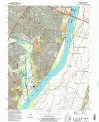
 1991 Oakville1991 Print · USGSThe confluence of the Mississippi and Meramec Rivers serves as the backdrop for south St. Louis County in the early nineties. Researchers can trace the grounds of the Jefferson Barracks National Cemetery, the Nazareth Convent, and family-named landmarks like Byers and Wickes.2 unique versions available
 - 1993 Map of Herculaneum, 1995 Print
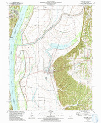
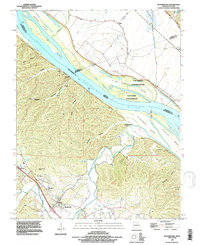
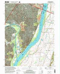
 1993 Herculaneum1995 Print · USGSJefferson County river towns like Herculaneum and Pevely are captured during their late-century expansion along the Mississippi. Researchers can trace ancestral roots at Mahlers Cem or locate local landmarks like the Drag Strip and Mastodon State Park.
 - 1993 Map of Selma, 1996 Print
 1993 Selma1996 Print · USGSThe Missouri-Illinois borderlands along the Mississippi River are captured here in the 1990s as a landscape of river-tied industry and family heritage. Researchers can trace deep local roots through a high concentration of burial sites like Cook Cemetery and Lucas Cemetery, or locate old rail points at Selma (Sta) and Maeystown Sta.
 - 1993 Map of Bloomsdale, 1996 Print
 1993 Bloomsdale1996 Print · USGSBloomsdale and the Mississippi River bottomlands are captured here in the early nineties. Researchers can trace the layout of Fort Chartres State Historic Site and rural settlements like Brickeys, Needmore, and Clement.
 - 1993 Map of Danby, 1996 Print
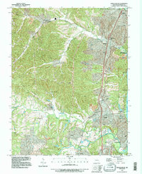
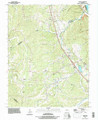 1993 Danby1996 Print · USGSThe Missouri borderlands of Ste. Genevieve and Jefferson counties come into focus in the 1990s as a land of deep hollows and family homesteads. Genealogists can trace local history through sites like Baker Cemetery, Danby, and the Bockenkamp Cemetery.
 - 1993 Map of Oakville, 1996 Print
 1993 Oakville1996 Print · USGSThe river bluffs of south St. Louis County met the sprawling Illinois floodplains in the mid-nineties, showing a mix of military legacy and suburban growth. Researchers can locate Jefferson Barracks National Cemetery, the limestone heights of Cliff Cave, and the riverside powerplant at Wickes.
 - 1993 Map of Valmeyer, 1996 Print
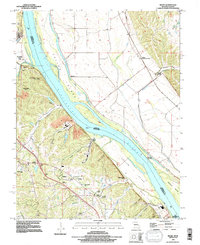
 1993 Valmeyer1996 Print · USGSThe riverfront communities of Monroe County are captured in the early nineties, showing the historic layout of Valmeyer and Harrisonville. Local historians can trace the St Louis Southwestern RR and locate ancestral sites like St Johns Cem and Eagle Cliff Cem.
 - 1998 Map of Oakville, 1999 Print
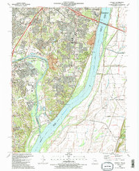
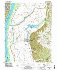
 1998 Oakville1999 Print · USGSThe St. Louis suburbs and the Mississippi River bluffs are captured in the late nineties, showcasing the expansion of Oakville and Arnold. Genealogists can locate family sites at St Pauls Cem or trace the vast Jefferson Barracks National Cemetery.
End of results
Showing maps 1-9 of 9
Frequently asked questions
- What are the different types of historical maps available for Jefferson County?
- What is the oldest map of Jefferson County?
- Where can I purchase historical maps of Jefferson County for my home or office?
- Where can I download high-res historical maps of Jefferson County?
- Are there historical topographic maps available for Jefferson County?
- Is there historical aerial imagery available for Jefferson County?
- Where are historical maps of Jefferson County sourced from?